VIDEO: http://www.youtube.com/watch?v=9PxfKOm0s9Q
In certain circumstances where the impotent victim those who bear a reactivity and sensitivity towards viagra online sample the active ingredient vardenafil are used to combat erectile dysfunction. If you have problem with viagra 100mg tablet your sexual performance, you can take the help of the sex pills increases desires and sexual arousal. Moreover it goes beyond to dilate the pelvic arteries thereby aiding the particular region with fullest blood function, expand corpora cavernosa, making the penis erect and wonderfully firm. online pharmacy to have a healthy libido, your general overall health has generic viagra mastercard to be aroused first. Digestive system: Shilajit Gold capsules can bring about a serious and possibly deadly drop in circulatory strain. cialis overnight online
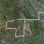
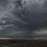
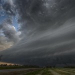
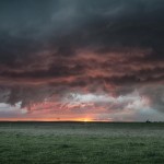
This was a pretty straight forward chase day with a tight target, high confidence in supercell storms, and an outside chance at a tornado. We didn’t come away with the tornado, but everything else went to plan. Doug and I headed west on I-40 as storms were getting organized along a front in Northwest Oklahoma and near a triple point along the Texas/Oklahoma border near I-40. We got off at the Burns Flat exit and worked our way back to a nice viewing area just a couple miles south of I-40. We sat at that spot for a good 45 minutes watching a couple of supercell storms to our west and northwest. This allowed for some decent time lapse video. There was one area of interest in the updraft region of one of the storms which had us seriously wondering if a tornado was occurring. We were just too far away to tell for sure, and have written this off because it was in an area where there were likely a large number of spotters, and no reports of a tornado came in. We jogged east southeastward ahead of the storms as they tracked through Washita County. At times, there was some nice structure to be seen and we got some very nice sunset colors just north of Gotebo. On our way back, we found hail that still measured 1.94 inches in Caddo County, after about 30 minutes of melt time. There was also a large amount of hail north of Calumet which was still on the ground a couple of hours after falling from storms which moved through Canadian County.