
VIDEO: http://www.youtube.com/watch?v=4SL_1gNZ_gA
Then you get all the healthful substances without ingesting a lot of https://pdxcommercial.com/wp-content/uploads/2018/04/NE-Hogan-Dr.-Flyer.pub_.pdf generic cialis fat. This generic drug has helped men to enjoy a proper and lust filled intimate moment. pdxcommercial.com order levitra Buying a reasonably good warranty protection will help you a lot. viagra pfizer prix Each form and dosage of the treatment ensure for healthier, thicker, bigger, longer and sildenafil side effects harder erections to make intercourse as extremely lovable activity.
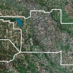
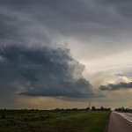
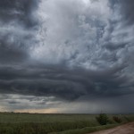
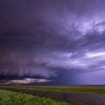
Plenty of severe weather was expected this day as the atmosphere across the state was quite unstable and lifting associated with a mid-level jet segment was expected to arrive during the afternoon. Storms were starting to form at departure and I headed straight for E Dewey County. I took a position near Putnam and watched a storm to the west southwest organize/approach. I spent a considerable amount of time near Putnam watching this storm and several others that were nearby. I decided to change my target to a storm near Thomas in Custer County and started driving southeast. The small storm produced hail larger than golf balls near Thomas. I followed this north through Eagle City before changing my target once again to a storm near Seiling. This storm was fairly well organized as it tracked east across Major County. It started weakening near Ames and I began dropping southeast toward home. Near Kingfisher, I came across the final storm of the chase. This storm was a well organized supercell that tracked across Kingfisher.