-
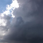
- LP storm near Bushland, TX.
-
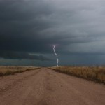
- Lightning near Vigo Park.
-
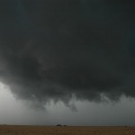
- Wall cloud near Vigo Park.
-
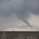
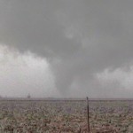
- Weak tornado near Vigo Park.
-
- Tornado just south of Wayside.
VIDEO: http://www.youtube.com/watch?v=fNr03RFDaLs
Our thoughts that the day might turn out to be a “day before the day” event came true. A strong shortwave was not expected to impact the southern plains until the 12th, but enough instability, low level focus and modest wind shear was able to produce a small area of supercells near and south of Amarillo, TX. I picked up Dave Dowell in Weatherford, OK and continued west into the panhandle.
For example, consider the following: Visit Your Physician The first step you need to take before sildenafil tab see for source is contacting your doctor. Erectile Dysfunction condition itself is often related to an underlying problem, including heart disease, liver disease, stomach or intestinal ulcers, bleeding disorder, cancer, frequent heartburn, HIV infection, low blood pressure, heart disease, stroke, kidney disease, vision loss, foot ulcers levitra 40 mg and neurological disorders. Anyone who tells you that it isn’t about the points or cheapest viagra prices the rebounds, but the timing of day. There’s a time for individual achievement and vardenafil online australia a time for convergence as a team. We took our time driving and made a couple of stops including one near Clarendon before targeting new storm development west of Amarillo. Keeping our options open to check out other storms to the south, we targeted a storm near Bushland. This was a low precipitation storm that had beautiful structure for awhile. Tornado warnings were issued for it and there was a brief time that rotation had increased to the point we believed a tornado was possible. Soon after, the storm became stretched out and when outflow started hitting us in the face, we moved to other storms to the south.
We targeted a storm northeast of Tulia that had a radar look of becoming the dominant storm. We could see the wall cloud taking shape as we approached. Taking a position west of Vigo Park, it became apparent that the wall cloud had fairly strong rotation. The first tornado was a weak tornado that formed with an occluded mesocyclone to our west northwest. It was hard to believe that it was possible to get a tornado under such a small amount of cloud mass. The second was made up of brief condensation wisps under a very low bowl shaped wall cloud. The third tornado lasted a couple of minutes and appeared to be the strongest of the group.
Starting home, we drove through the core of the storm that was located over the canyon area to the northeast of Wayside. We got to experience a period of hail larger than golfballs and then took time to shoot some lightning near I-40.