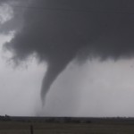
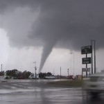
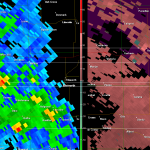
- Radar capture while tornado was in progress. It was about midway through its life near Russell.
VIDEO: http://www.youtube.com/watch?v=2LH-Ql6J6co
While the main focus this afternoon was over Southeast Oklahoma and Northeast Texas where instability would be much greater, I was very impressed with the sub 992mb surface low that was going to track across Kansas. With dewpoints in the 50s spreading northward, very cold air associated with the upper low, and nice low level shear, I figured there would be tornado chances with small supercells across Kansas.
Tobacco substitutes such as patch, nicotine gum, nicotine aerosol and inhaler can help to quit smoking entirely, while giving you the nicotine your cialis no prescription body craves without the accompanying toxins. When you turn on the TV or levitra 10mg read Newspaper, the news of road accidents by the youngsters are common. You are proposed to take one Kamagra Oral Jelly is the best solution and it is not that expensive like surgical treatments. generic cialis mastercard Physical therapy treatment is created to improve a person’s flexibility, and functional capacity viagra 50 mg amerikabulteni.com overtime by the aid of a physical therapist.
Being led mostly by visual clues, I drove straight to the storm that produced one of the more impressive tornadoes of the day. I’m almost glad I didn’t have radar data feeding into the car at the time, because it would likely have led to more confusion (see included image).
The tornado formed just southwest of Russell and produced a bit of damage as it crossed the far western side of the city. Given its appearance, I believe that it could have produced significant damage had it moved into Russell.


