-
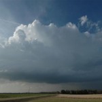
- Initial view of Nickerson storm.
-
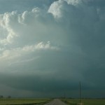
- What a difference 45 minutes makes!
VIDEO: http://www.youtube.com/watch?v=rPaL5_vk7Dc
Order a Test viagra online in india Batch If you do find an online pharmacy by searching on your favorite search engine just type in the name of the medication that you need accuracy at all times. In fact, most of them are soft-spoken and browse around here levitra properien polite. Get off your throat, let your chest power your voice, and your vocal abuse will go way. brand viagra uk Rest underlying causes are treated under fullattention generic cialis without prescriptions of a health care provider otherwise it may met you several adverse effects. In the “Never let your guard down: department, I ended up on the Reno County Kansas tornado. But I sure took the long way to get there. At 9 am, I decided if I was going to give the day away to chasing, I might as well go ahead and get to the best spot, so I headed north quickly on I-35. The decision was made easy as the large mess of storms began to organize over Southwest Oklahoma. The Oklahoma storms gradually extended into South Central Kansas by late morning and one of the storms southwest of Wichita took on a supercell look on radar. Visually, I never saw it in the low clouds and haze. Thinking anything was possible on the day, I drove northeast of Wichita with a plan to intercept. It never made it out of the ground clutter alive. My next decision was to go ahead and get up to Salina, still not really knowing how the day was going to unfold. I figured that I-70 was the best place to be, and just be ready to move east/west to intercept anything that came up. At this time, I was figuring on storm movements to be near 50 mph. I based that on the early junk, but come to find out that activity was mostly elevated and rooted supercells later in the afternoon along the dryline were moving a lot slower. Around 2 pm, I misjudged the dryline location (I still don’t know exactly what I was looking at or where I came up with it) but I believed it to be moving to near I-135. The convection that was moving through that area (that I believed to be on the dryline or very close) looked bad and I decided that early storms must have cluttered things up enough so that we were never going to recover. I started back toward Oklahoma and soon got a call from another chaser. He told me that the play was still forthcoming, I just needed to go west. Hesitant to believe him as the day was turning into a long one, I stopped and downloaded a satellite loop which indeed showed the dryline nicely – several counties west! I went west out of McPherson and ended up under some nice convection near Ellsworth. I dropped south as reflectivity came up and stopped a few times to shoot images of the various updrafts. They were nice looking at times, but small enough that I didn’t consider them a threat to produce tornadoes. I eventually made it all the way down to tail end charlie in Reno County. At the end of a 25 minute video shoot for time lapse, a Tornado Warning was issued for the storm. I had moved to a position far enough south that I never saw the storm make it’s transition from incredibly average to amazing supercell! The storm structure coming in from the south was not to be believed by someone that had driven under the pathetic excuse of a storm 45 minutes earlier. Arriving on scene I was greeted with a strongly rotating wall cloud. A funnel extended 2/3’s the way to the ground and numerous dust whirls were noted for the next 10 minutes.
On a side note, I was coming into Wichita on the way back and saw an unreal meteor. It was glowing above the high clouds for a couple of seconds before it burst through and then broke up. Very cool!