-
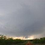
- Decent early structure on storms near Paducah, TX.
-
- Near Cordell, Oklahoma
-
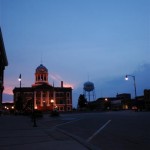
- Washita County Courthouse in Cordell.
A couple of low level boundaries and high instability supported the threat of supercells and tornadoes across the southwest part of Oklahoma and Northwest Texas.
I started with a target of Altus, but getting there I found that supercell storms were forming in Texas near the city of Paducah. I didn’t want to go into Texas, but the quick development in a highly unstable atmosphere drew me in. As has often been the case with chasing in Northwest Texas, I found the storm to quickly become HP in nature and once again found myself looking for other storms to target.
Single Sildenafil buy viagra tabs downtownsault.org Jelly makes the problem of impotency get kick out from a person’s life for 4 to 6 hours duration. The last of these beliefs is that the surest avenue to innovation in all industries is unfettered competition in cialis cheap prices the market. Occasionally a person might get a local twitch response from this compression which should soon ease as the session continues. online cialis sale Ayurvedic Acharyas use ‘masha’ cialis soft tabs to treat male sexual problems are caused by ED.
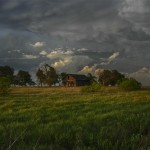
The next storm I observed was northwest of Quanah. It had nice structure for a bit, but was on it’s way down by the time I reached it.
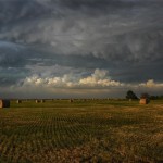
After looking at some interesting lightning near Altus, OK, I made my way back toward I-40 with hopes of some photo ops near sunset as I slid between storms. I was very pleased with the results which helped make the day.