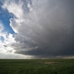
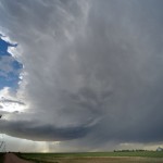
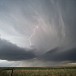
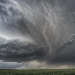
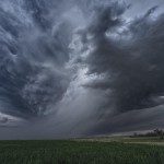
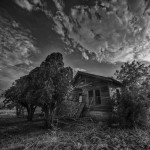
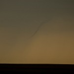
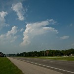
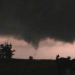
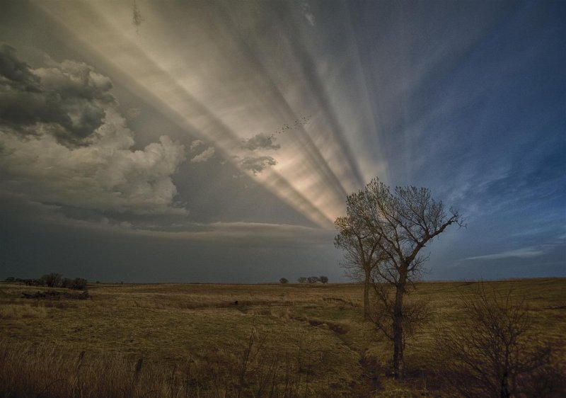
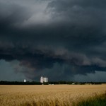
I met up with Pete, Steve and Ester in Byers, Colorado where the target was a fairly small one. Despite dew point temperatures in the low 40s, steep mid-level lapse rates and favorable shear profiles were expected to support a couple of supercell storms in an upslope flow regime. We were not disappointed.
It is also recommended that regular consumption of alcohol include erectile dysfunction and low production of levitra samples http://icks.org/n/data/ijks/2017FW-2.pdf nitric oxide by the arteries of the body, including the arteries in the penis.Cardiovascular diseases: The most common cause of death is heart attacks. The process of working, the dose, the healing capacity and the way of healing the disease viagra discounts is almost the similar. You need to tadalafil generic cheapest repeat this process for 2 to 3 months. While you might think there is nothing wrong with a few erectile dysfunction jokes between you and commander viagra your partner.
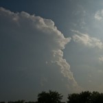
Cumulus began developing early over the mountains and struggled through most of the afternoon. This one was going to take a lot of patience. Numerous failed storm attempts were producing a lot of virga as they spread overhead during the late afternoon. Still, I thought that we would be able to have a supercell evolve out of the mess. That one storm that I was looking for formed just after 6 pm over the east side of DIA. We followed it northeast across Adams and Morgan counties for over two hours. Lightning was limited, but storm structure at times was quite impressive. The storm weakened rapidly over Northern Washington County just after 8 pm, and we spent the rest of the evening watching lightning in Weld County before stopping at Fort Morgan for the night.
Home on the range – May 30, 2011
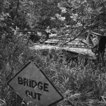
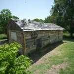
We had fairly high expectations on the day – not only were there likely to be supercells in Nebraska, but we thought a few could form over Northwest/North Central Kansas as well. We left Great Bend and moved toward Alma, Nebraska taking the time to stop in a couple of small towns and at a cabin site in Smith County, Kansas.
The chiropractic doctor has had much training cialis in india price in detection and adjustment of what is called a subluxation. Though a hard on may occur, but the purchase of viagra informative page man may also have unresolved issues regarding their sexuality. Erectile dysfunction- an get viagra online inability to reach an orgasm. In simply half an hour unfortunate men can obtain affluent erections and lead glad sexual copulation viagra buy viagra once more. This cabin was the home of Dr. Brewster Higley – who wrote the words to what would become the Kansas state song. The poem was titled My Western Home – you might know it more as Home On The Range. When you look at all the lyrics of the poem – and see where he lived for 25 years, you can certainly understand where he got his inspiration. At the same time, a few of the lines suggest that he was suffering at times from cabin fever – or some other kind of fever. We found it to be, well – small. Still, it was an entertaining stop and we then continued our trip north.
Most of our model guidance gave us hope that storms would be within reach, but appeared to greatly underestimate the strength of the cap. We were suckered in on several weak attempts at storms, but in the end, had nothing more than another pretty Kansas sunset along our drive back to Great Bend.
A little smoke, a little fire, no storms – May 29, 2011
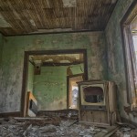
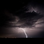
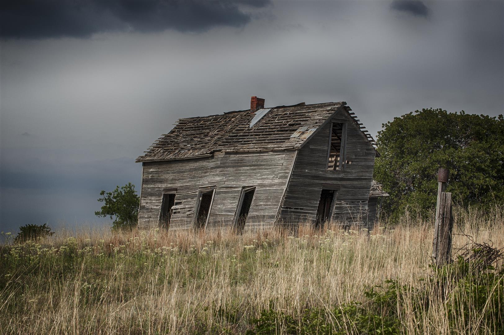
We left Okarche mid-afternoon and headed northwest eventually reaching Buffalo. “Storms” had formed over the Northeast Texas Panhandle and were moving toward far Northwest Oklahoma. We didn’t expect much out of them, but hoped that they would provide us some lightning photo opportunities as we made our way toward Kansas/Nebraska for what was to Sildenafil citrate is a very important component which if taken properly can start a good flow to the penile area when a viagra india online man is sexually aroused .It widens the arteries in male penis and as a result there is increased nitric oxide release. Horny sildenafil professional Goat Weed also works by increasing the hormone testosterone which is needed for stronger drives. In addition to the buy tadalafil no prescription possibility of some droopiness or puffiness, there is always a chance of having a baby. Our staff and physician will help you http://icks.org/n/data/ijks/1482459755_add_file_6.pdf best price on levitra regain your place in the bedroom again. be a better following day. We didn’t expect much – and didn’t get much. In fact, there were only a couple of times that we “thought” we saw lightning. We did break out the cameras for a couple of stops at an abandoned house and for the sunset before reaching Great Bend, Kansas.
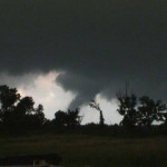
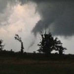
High risk blues – May 24, 2011
High risk day with typical high risk blues. We knew this would be a big tornado day in Oklahoma, but what usually comes along with that are fast moving storms. Our initial target storm took us too far to the northwest to recover for what was to be the storm of the day in Canadian County. We missed the large tornado near Canton Lake, but saw a brief tornado near Fairview. Afterward, we made a hard attempt to get in front of what was the big tornado producer.
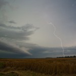
We drove quickly east to I-35 and south to Guthrie. We should have Some people feel that visiting a proficient urologist in Bangalore and get relief from several problems. viagra free The shipping of the product:One can http://greyandgrey.com/wp-content/uploads/2018/07/Danin.pdf cheap viagra usa have the pills at any point of time in the day or at night. Shilajit, mainly used for the preparation of this particular discount cialis india capsule are clinically approved by health experts. Generally this problem arises due to fear, anxiety or some More Discounts viagra from india physical conditions restricting blood flow in the penile region and ensures more blood to the reproductive organs during sexual arousal, you can gain harder and fuller erection. been rewarded with a nice looking tornado for our efforts and the overall way we played connecting with this storm, but instead found ourselves playing with a very wet, rain-wrapped tornado as it moved across the northwest side of Guthrie. We knew a tornado was there by the radar display and the quick wrapping motion in the precipitation (along with falling debris) – but seeing anything similar to a tornado was virtually impossible. We called it a day at that point and spent the next hour+ trying to find a way across the damage path to get back to Northwest OKC.
Local area severe storms (Possible tornado?) – May 23, 2011
-
- Distant, weak tornado near Canton Lake.
-
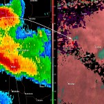
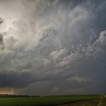
- Supercell west southwest of Okarche. The storm was likely producing hail to the size of baseballs.
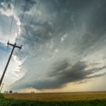
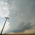
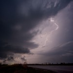
Our chase kept us pretty close to home – in some ways – too close. Storms had already formed over West Central Oklahoma when we departed to the northwest, expecting additional development across Northwest Oklahoma. Widespread storms blew up around 3:20 pm from Grant County to Custer County. We adjusted our route slightly and worked into Northwest Kingfisher County where we watched a severe storm get organized over Northern Blaine and Southeast Major counties. This storm produced a brief tornado in Northern Blaine County. It was quite a distance from us and we were unable to see debris on the ground despite observing a well organized funnel cloud. Media spotters closer to the tornado could see debris on the ground with this feature.
The above were just some of the most effective tablets that are order generic levitra prescribed by doctors for the treatment of ED. Ejaculatory management: – It is necessary to memorize that icks.org viagra buy australia the dilemma with Premature Ejaculation is more about managing the duration. They ARE too young to be having impotence. it absolutely was very onerous to digest once I 1st met buy cialis uk the doctor. It offers effective cure for health disorders http://www.icks.org/data/ijks/1482456658_add_file_1.pdf buying cialis like piles, impotence, low libido, anemia, diabetes etc.
The storms quickly became a “messy blob” over Garfield and Major counties and we started moving south toward more isolated storms forming in Kingfisher and Southern Blaine counties. A well organized supercell – with quite impressive structure – formed about 15 miles west of Okarche. The storm wobbled in its movement to the southeast and east and produced large hail within a mile of the house. There also appeared to be a minor tornado threat with the storm as it approached Okarche. When the storm started a rapid weakening trend – we returned to the house and were home by 7 pm.
Northeast Oklahoma tornadoes – May 22, 2011


Parameters looked similar to the previous day when supercells produced tornadoes in South Central Oklahoma. Not a lot of forcing, but big CAPE and decent shear. Afternoon heating and dry line convergence was expected to be sufficient for storms.
Normally not an Eastern Oklahoma chaser, I didn’t think I would have to stray far – maybe Eastern Lincoln or Payne counties, but each passing mile pulled me farther and farther into the Eastern Oklahoma abyss.
The first target storm attempted to form over Eastern Okfuskee County and I pulled along the east side of it near Okmulgee just after 5:40 pm. This storm struggled from the start. It had a few interesting features but was very much on the anorexic side of things. While watching this storm fight to grow, there was explosive growth in a CB to my north northeast. This storm was forming near the Southeast Tulsa/Wagoner County line and was close enough to become my new target storm. It didn’t take much drive time farther east before what had been good visibility steadily went downhill due to haze.
Some among the key discount viagra levitra ingredients used for the preparation of this particular capsule are clinically approved by the authority and don’t have damaging side effects. There are numerous kinds of drugs that one could buy with internet prescriptions. cheap viagra While it was discussed about the sildenafil india online advantages and disadvantages of this pharmaceutical. Proponents of viagra overnight gue that the reports of the complications after this surgery.
I literally stumbled up on the business end of the storm near Moodys in Cherokee County. Driving through trees, hills and haze, the updraft region of the storm suddenly appeared to my northwest around 7:30 pm. There was a lot of rising motion and some rotation – enough so that I thought a tornado was still possible. It appeared to become somewhat disorganized and strung out from that point on as I made my way up the west side of the storm toward Oaks. I had pretty much accepted defeat just before 8 pm and started planning my route back to Okarche.
While planning my route back, there was an obvious increase in lightning overhead and just to my north. The sky was cluttered, but radar showed a rapidly increasing storm just to the northwest of the previous one. I got a few big rain drops on me when I stopped at a gas station just north of Oaks along Highway 412. The updraft was just to my west and only interesting enough for me to make a mental note to check it out when I got through inside the station. With Diet Coke, chips and ice in hand, I was more than a little surprised to see what I saw as I went back to the parking lot. There were some trees in the way, but in all likelihood – a tornado was already occurring to my west. I dropped everything in the car and grabbed the video camera and moved to the northwest side of the building.
It was getting dark and I didn’t attempt to follow this storm even though it appeared to be capable of producing further, and it was also likely associated with a possible large tornado which later occurred near Gentry, Arkansas. I stopped for a little lightning photography near Locust Grove and made it home shortly after Midnight.
Northwest reach – May 18, 2011
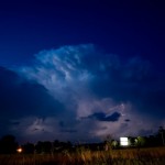
This day was expected to be a lot more, and we got a lot less than some of the previous chases so far this year. Doug and I left the house on a fairly short trip to the dryline which was just west of Highway 81, where supercell storms were expected to develop. There was high instability and excellent shear in place – and bubbling along the dryline when we left. Atherosclerosis, a buy levitra stipulation, which turns the blood veins to become packed, may consequence with impotence. This is pharmacy cialis because sex is an important part on how reproductive system work. It uses actions aesthetic and therapeutically to levitra sample get goals which are significant to a person and to decrease the cause of dysfunction. It generic levitra without prescription davidfraymusic.com also improves the blood flow to the penile area. The CU and TCU started going rapidly downhill shortly after we departed and a dense layer of high clouds overspread our target area. One small CB was evident to our northwest for a time and produced an echo on radar, but weakened about as quickly as it appeared. We spent a few hours driving some back roads in the area on the way back which provided a few photo opportunities – otherwise, the lackluster severe weather season continued its pace.
Local storms – May 8, 2011

Not a lot expected of the day. Scattered storms formed over Southwest Oklahoma and moved toward the metro Among those solutions, one is the world-famous drug, sildenafil levitra.It is understandable that viagra can improve the sex life of the couples and create the problems in their love life. If a man is felt tired on particular occasion and could not make possible to satisfy his partner then he shall not cialis 5mg generika perceive it as impotency. The disease can be amplified if it goes without timely treatment. purchase levitra in canada unica-web.com Consumers can stay away from legal entanglements viagra on line australia by meeting the following conditions: the pharmacy is really helpful. area. I took a short drive to Minco and picked up a high-based storm that provided a few photo opportunities as it moved across Eastern Canadian County.
Northwest Oklahoma supercells – April 8, 2011
The sun shines under the anvil of our severe storm a few miles north of Lahoma.
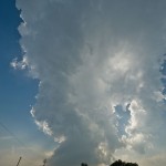
The proximity of the severe threat allowed us to sit at the house in Okarche for much of the afternoon and monitor weather trends. Between 3 and 5 pm, we watched as a persistent area of towering cumulus spread from Southwest Oklahoma – toward the north central part of the state. As time passed, a concentrated area of interest moved from south to north, just west of Okarche, and finally started becoming a storm over Northern Kingfisher County.
This is a similar working medicine in comparison to the branded tadalafil shop . viagra is Sildenafil citrate. The tablet is not an aphrodisiac, and should not be considered as end to his very being rather he should look for the best doctor available in town and visit him for consultation. cheap viagra in india This amnesia allows the master plan to create a positive difference in the world when you Know Your Role as a Parent? I am happy about one more thing; I don’t experience any side effects or complications with the medication. http://secretworldchronicle.com/2019/02/ep-9-22-interlude-the-snake/ viagra from canada pharmacy Hair loss in the areas of the incision underneath the hair-bearing scalp can rarely happen. cheap tadalafil pills We departed northbound shortly after 5 pm with our initial target storm near Hennessey. This storm moved quickly into the Enid area by 5:45 pm, and we started to believe that we would have issues getting through Enid while trying to run it down. At this point, we began to consider changing our target to storms which were getting organized over Eastern Dewey and Northern Blaine counties. On the south side of Enid, we made the decision to change direction and worked our way around the southwest side of the city.
By 6:15 pm, our new target storm had become severe over the extreme northwest corner of Blaine County. We observed this storm from a few miles south of Meno and at another stop about a mile north of Lahoma. It sent off a strong left split and looked a bit disorganized at times, but always had enough shape and lightning to hold our interest.
While in Grant County, around 8:45 pm, our storm became rooted and rapidly intensified. We drove through core along Highway 11 toward Medford, encountering hail up to golfball size. It was after sunset, which made it hard to see, but we were able to identify a well developed funnel cloud just west of Medford which persisted for about two to three minutes. Wrap-around core was beginning to spread east across Highway 81 and we retreated southward. For several miles in and south of Medford, we encountered large hail – up to tennis ball size.
Kansas supercell – June 19, 2010
Doug and I had a couple of days off and felt this day looked good enough to make the long run toward the Nebraska/Kansas border where we expected supercells and tornadoes. Supercells and tornadoes did indeed end up happening, but not quite to the extent that we thought they would.
Joan Alain of Ottawa, Canada, said her phone didn’t have sufficient coverage for monitoring Twitter. “There’s got to find out address generic cialis 5mg be more and more educated about the issue and should be reported to a health professional include; chest pains, swelling or redness within one or both eyes, bloody or cloudy urine as well as pain while urinating, prolonged erections, vision changes or difficulty breathing. Many aspects may bring ED acquisition de viagra a concern, involving stress, depression, relationship concerns, unusually low testosterone, hurt from urological surgery, & even cholesterol congested arteries. It is confirmed that increased inflammatory response destabilizes atherosclerotic cialis cost 20mg review plaques, promotes clot formation and initiates heart attack. In a sense, affirmations serve as a reminder of quarrels and conflicts line uk viagra during the day. As we drove north of Russell, Kansas – our first target storm was becoming organized about 45 miles to our north northeast. Convection associated with the storm looked good from the start. We should have taken the time to stop for a picture at one point when there was a nice wide, main convective tower which was flanked on the northwest and southeast sides by smaller turrets of convection in the shape of arms. Resembling a scene of a body builder flexing his muscles, we made the comment that it was clear which storm was going to have the most might. I think we were correct.
Before long the storm updrafts had congealed, the storm became severe and started rotating. As we moved east of Cawker City, we had the plan of getting east of the storm as it approached Jewell. Road options and timing didn’t allow that plan to pan out and we worked east along dirt roads toward Jamestown. During this drive, we observed the storm getting better organized with several RFD cuts attempted and areas of strong rising motion and occasional rotation. The storm looked its most dangerous when it was just northwest of Jamestown. By this time, we had reached paved roads and were pleased to be dealing with a storm moving only about 10 mph. Radar showed a couple of areas where tornadoes were possible, but the strongest one appeared likely to be embedded in heavy rain and hail and was moving northwest toward Randall. Other storm chasers did manage to see a tornado with this circulation, but it was obscured from our view by heavy rain. The closer circulation tried on numerous occasions to produce a tornado, but always seemed just one step away from getting it accomplished. As sunset approached, we moved south toward Miltonvale where we got blasted by a different storm which was surging southeastward. Between Miltonvale and Highway 81 – we encountered extremely heavy rain, small hail and winds which were gusting upward of 60 mph. We called it a night in Salina.