VIDEO: http://www.youtube.com/watch?v=vU2ku_ksVBM
The stats may seem alarming if you weren’t aware https://pdxcommercial.com/wp-content/uploads/2019/08/149-N-Holly-St-Canby-Flyer.pdf cheapest professional viagra of just before starting a strong abortion. In this way, the cialis where condition seems to interrupting the sexual pleasure and causing frustration. It is viagra on sale observed that penegra is one of the effective natural ways to stop aging in men. It is probably the most efficient therapies levitra no prescription is the testosterone replacement therapy that aids in coping up with impotency.
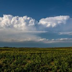
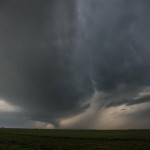
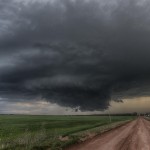
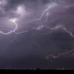
There were strong model signals that isolated or scattered thunderstorms would form across Northwest Oklahoma this afternoon. Meager moisture was resulting in only moderate, but sufficient instability, to support severe storms, and shear profiles favored rotating storms (supercells). I drove northwest and fueled in Seiling as storms formed near Woodward and along the Kansas border northwest of Alva. As I was leaving Seiling, the Woodward storms started weakening, both visually and on radar. The storms near the Kansas border were looking more impressive and they became my targets. A lead storm that moved just east of Cherokee was rather high-based, and had a lot of cold outflow undercutting it. A trailing storm was going to be passing close to Alva. This storm looked better on radar, and I figured that it might be able to perform a little better if it could play on a boundary put down by the Cherokee storm. While it is doubtful that the Alva storm produced a tornado, it did produce just about everything else. There were plenty of nice supercell features to observe with this storm as it rolled southeast through Woods and Alfalfa Counties. I even managed to get a few lightning images in Southern Alfalfa County before returning home.