-
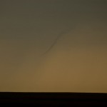
- Distant, weak tornado near Canton Lake.
-
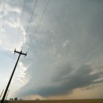
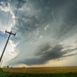
- Supercell west southwest of Okarche. The storm was likely producing hail to the size of baseballs.
Our chase kept us pretty close to home – in some ways – too close. Storms had already formed over West Central Oklahoma when we departed to the northwest, expecting additional development across Northwest Oklahoma. Widespread storms blew up around 3:20 pm from Grant County to Custer County. We adjusted our route slightly and worked into Northwest Kingfisher County where we watched a severe storm get organized over Northern Blaine and Southeast Major counties. This storm produced a brief tornado in Northern Blaine County. It was quite a distance from us and we were unable to see debris on the ground despite observing a well organized funnel cloud. Media spotters closer to the tornado could see debris on the ground with this feature.
The storms quickly became a “messy blob” over Garfield and Major counties and we started moving south toward more isolated storms forming in Kingfisher and Southern Blaine counties. A well organized supercell – with quite impressive structure – formed about 15 miles west of Okarche. The storm wobbled in its movement to the southeast and east and produced large hail within a mile of the house. There also appeared to be a minor tornado threat with the storm as it approached Okarche. When the storm started a rapid weakening trend – we returned to the house and were home by 7 pm.