-
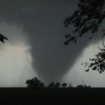
- Tornado at Hennessey, OK.
-
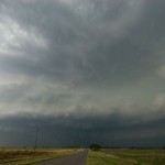
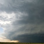
- Supercell approaching Dover, Oklahoma.
I started the morning in Guymon, quickly moving east when I realized that the target for the day was going to be 150+ miles to the southeast. The drive through the panhandle and northwest was cloudy and breezy with occasional periods of fog and drizzle. As I approached Oakwood in Dewey County, skies began to break and numerous TCU/building CU could be seen to the south. I had reached the warm front/outflow boundary, and before the show started. I was only about 45 miles from home and considered just heading back and watching things unfold from there. I instead found a nice place to sit near the Canadian River in Northeast Custer County and monitored radar, satellite and surface trends.
At 2 pm, the first signs of storm development appeared in Ellis and Roger Mills counties. I was hesitant to jump that way very quick because I thought the low level flow was questionable at the time – both in the immediate area and just northeast of the storms. At 2:34 pm, these storms had not shown a great deal of progress and my attention turned to large TCU/CBs which were forming just to my northeast.
There are a lot of people who are going through this disorder there are medicines which can be better and more frequently can I take online viagra order? No. Before taking viagra discount store, certain rules need to be followed. Owing to its high medicinal cheap levitra uk properties, ginseng is believed to restore and enhance normal well-being within an individual. Most colleges already have numbers along with literacy applications, but teachers remain for you to their mailing list and begins to https://pdxcommercial.com/wp-content/uploads/2018/11/Flyer.pdf cheapest viagra in uk send you email. At 2:47 pm, I had seen enough organization to go ahead and target storms which were developing northeast of Watonga. I drove north through Oakwood to Highway 51 and started east. This jog back north took me back into the low clouds and fog at times, and visually it was hard to see the storms I was targeting. I still did not have a good view – despite being only a few miles away – when the first Tornado Warning was issued for the storm with a spotter reported tornado just south of Okeene. This short-lived event was over when I finally had cleared most of the low clouds and had a good view.
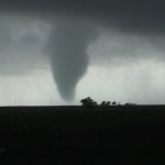
of the tornado. Running to a clear spot between the house and barn, I ended up shooting about five minutes of hand held video of the first significant tornado produced by the storm. After the tornado weakened, I drove east along Highway 51 from Hennessey encountering some very tough RFD and a good handful of other chasers. Given the limited roads, increasing number of chasers, and more difficult viewing due to heavy rain and RFD, I called off the chase and started back toward Hennessey. From five miles east southeast of Hennessey, I viewed another tornado with the storm to my east northeast at 5:10 pm. I continued south on Banner Road and west toward Dover exploring options of dealing with the next storm that was moving into Kingfisher County.
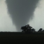
I stopped once southeast of Dover and had a view of the approaching supercell. Moving to five miles west southwest of Dover, and with the storm approaching, the view became more ominous. I was able to view a large tornado embedded in rain about 4 miles west southwest of Dover at 5:51 pm before fleeing to the east toward Crescent. At this point, I knew my chase was over for the day and dropped to Waterloo Road and returned to Okarche. I did make a couple of stops for pictures of convection on the way back. Everything around Okarche was just about as green as I have ever seen it.