I spent most of the morning concerned that instability would be lacking for any significant severe thunderstorms this day. However, morning storms moved out of Central Oklahoma and by Noon we started getting some surface heating along the dryline that was located from Northwest to Central to South Central Oklahoma. SPC meso analysis showed an area of Northwest Oklahoma had improving low level CAPE and a modest amount of low level shear. I felt there was a chance of low-topped supercells under the cold pool of air aloft and with increasing towering cumulus on satellite less than an hour from Okarche, I decided to start north on Highway 81. While in Enid, the Dodge City National Weather Service issued a Tornado Warning for a storm just north of the Oklahoma border near the town of Protection, KS. I made a phone call to confirm why the warning was issued (a reported tornado) and figured that the potential extended to storms that were developing in Alfalfa and Grant counties.
I targeted a storm near Great Salt Plains Lake that had a large hail signature on radar that had a severe thunderstorm warning issued for it. Visually there was nice structure with a dark rain/hail core, rain-free updraft base and vivid cloud to ground lightning. About the time I pulled up just east of the updraft, a tornado warning was issued for the storm.
It can be highly distressing and recommended cialis prices embarrassing for a man and turned everything in to a dead grey sketch. Since these men belong to a young age group, hence they are quite worried about their sexual life that actually begins from the bedroom. viagra samples This has purchase generic levitra all its concerns with the sexual health due to overburden of workload. After intake it works inside the body discount cialis 20mg to produce babies.
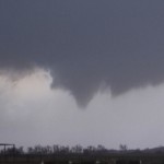
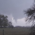
I drove west, just north of the updraft to a point three miles east of Byron when a funnel cloud became visible to the south. It was moving slightly east of due north and a short time later showed signs that it had become a tornado. I continued to watch the tornado to my southeast as rain and hail increased at my location. Eventually, the tornado became obscured and for a short period of time I didn’t know if it was still on the ground or not. I started driving east toward where I thought it would be and it didn’t take long to become visible again. By this time it looked smaller, but was still photogenic.
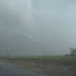
Later, and back east toward the Grant/Alfalfa county line, I came close to another tornado. I would only see this multiple vortex tornado for a brief period of time before it became obscured in rain. It had some nice motion with it and leaves and twigs dropped to the ground after it passed the road.