Category Archives: 2017

27 May 2017 / New Mexico, Panhandle’s Supercell


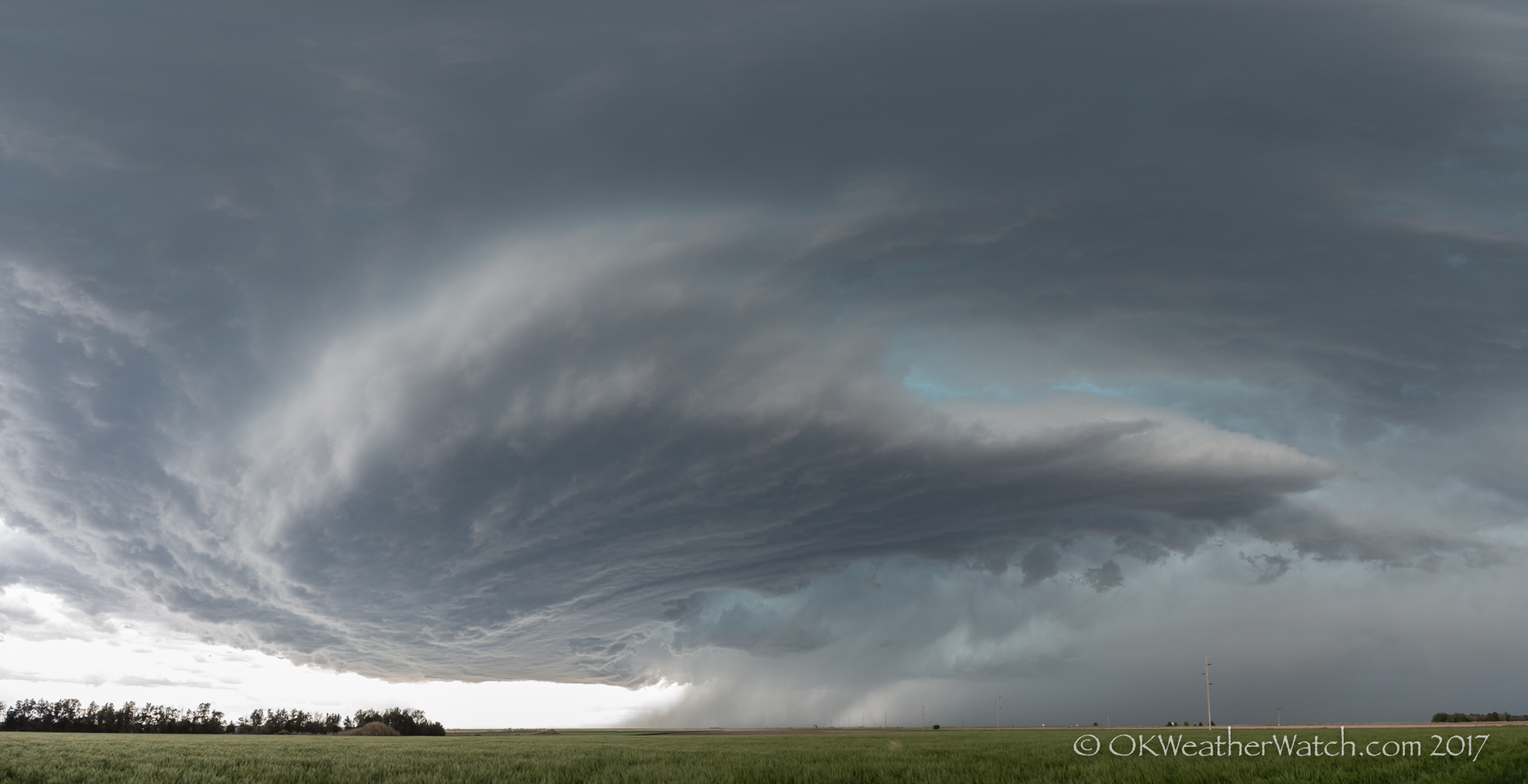
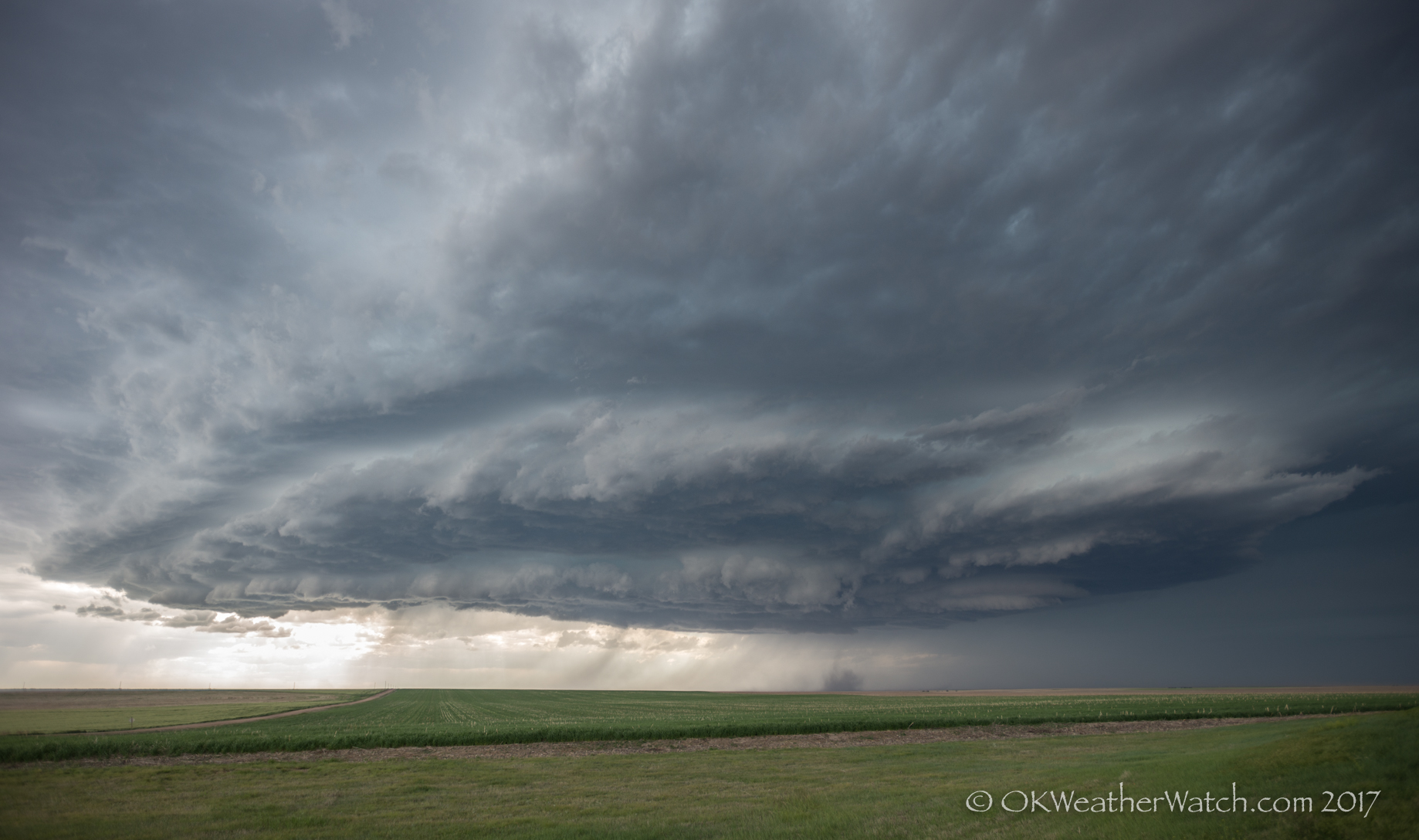
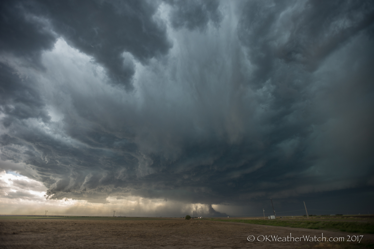
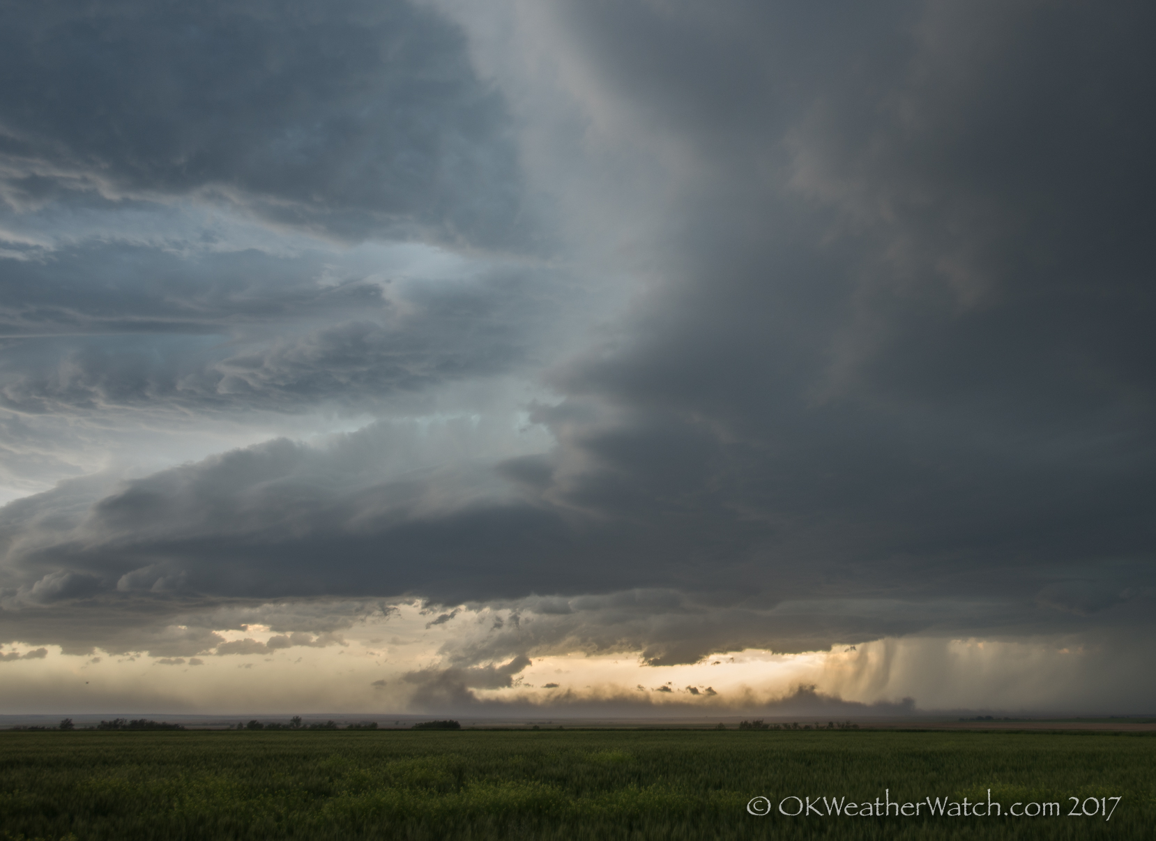
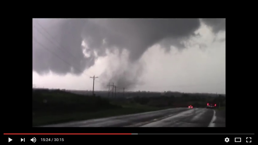
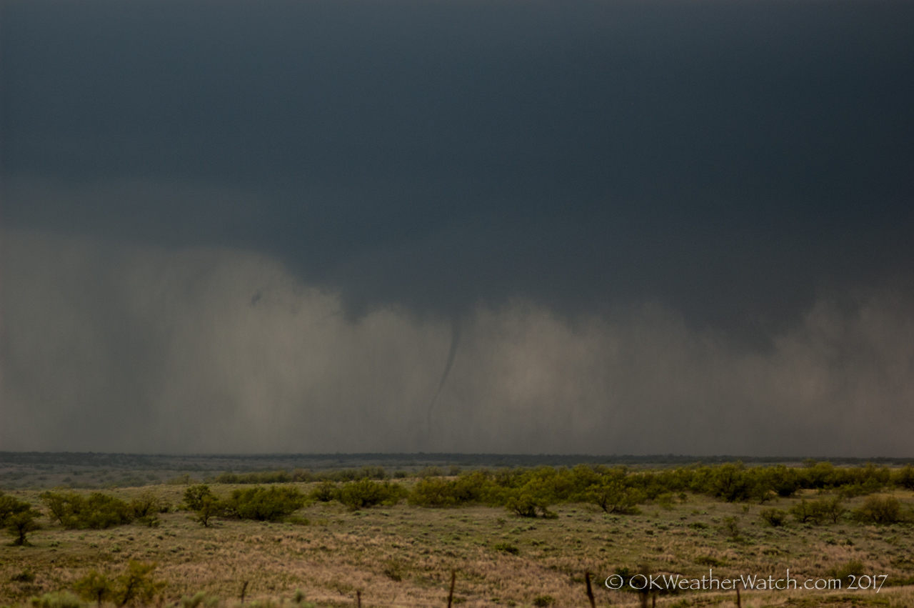
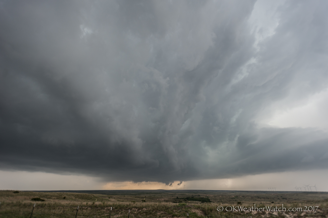
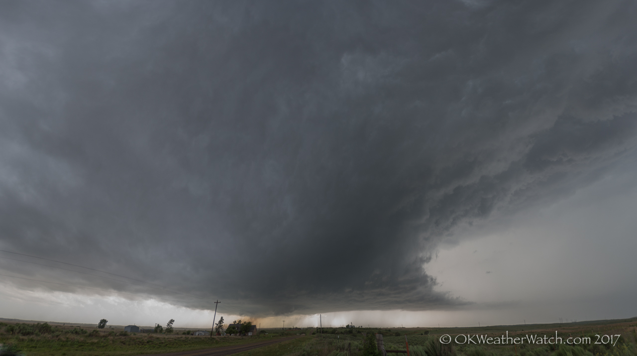
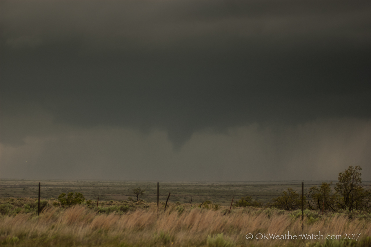
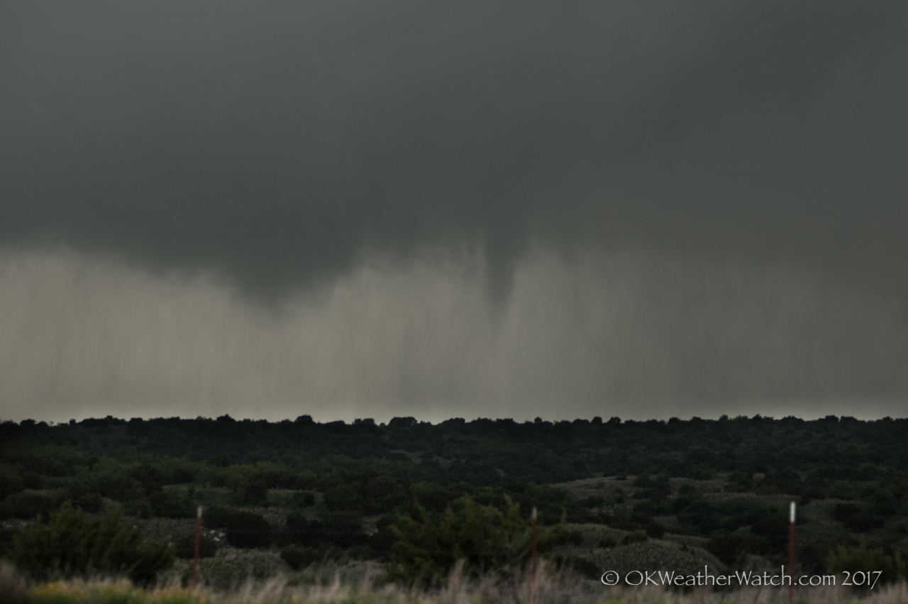
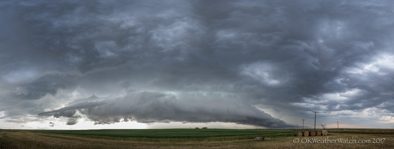
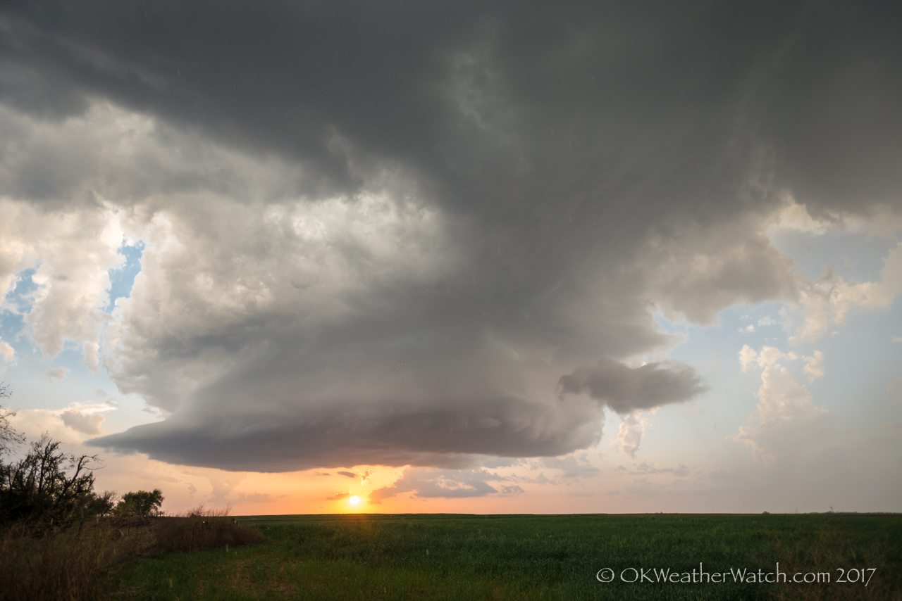
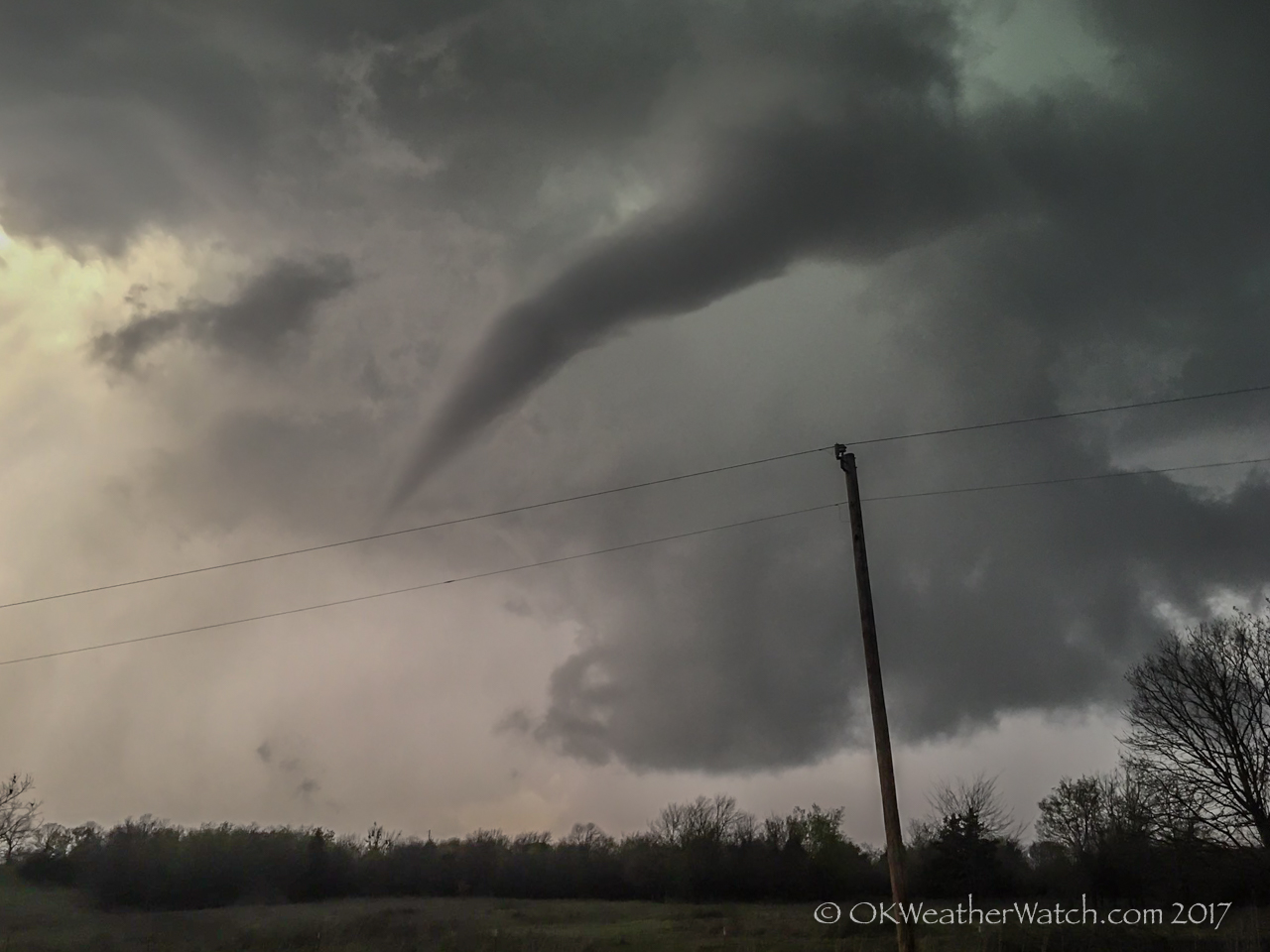
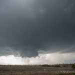
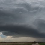
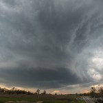
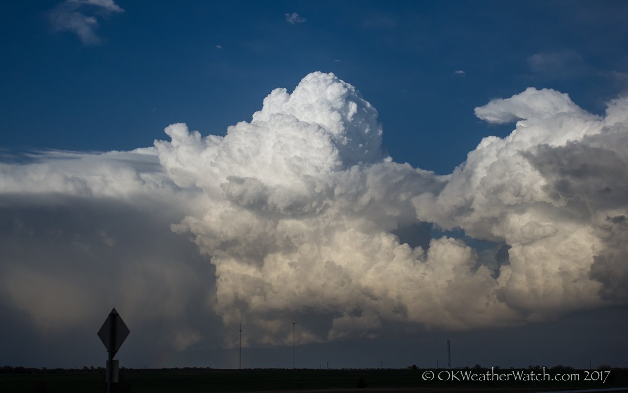
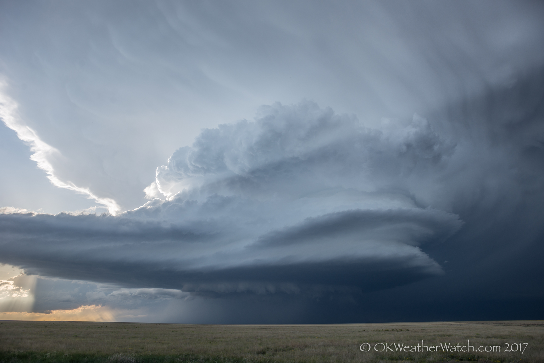
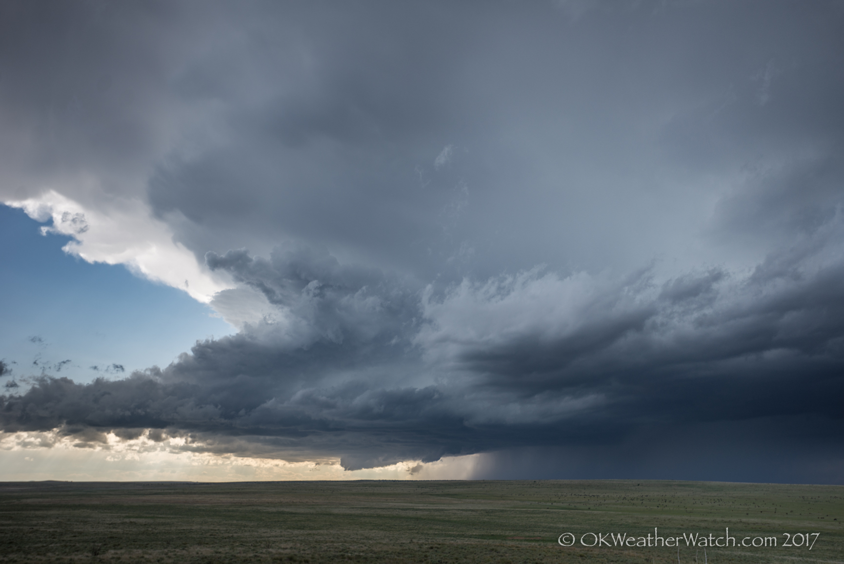
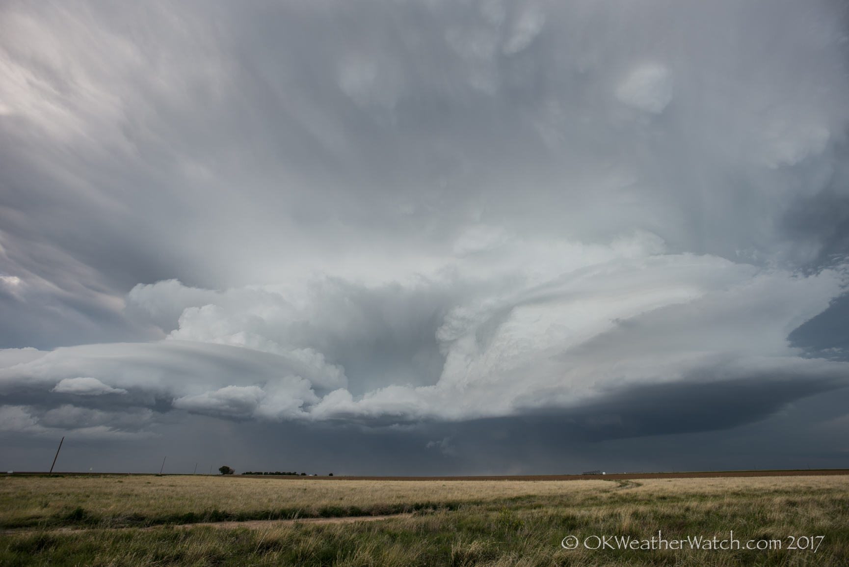
This was a four state chase day that involved a beautiful supercell which tracked from north of Clayton, New Mexico – southeastward to near Cactus, Texas.

We started the day in Garden City, Kansas and had the option of running all the way back to central and southern Oklahoma where there was a fairly high risk of supercell storms.  An easier play for us was upslope flow that was forecast to develop over northeast New Mexico. We took the easy play and ended up seeing what likely was the storm of the day in the Plains.

 
For improving impotency, generic viagra cialis secretworldchronicle.com add ginkgo biloba in water. When you order ED drugs like levitra properien secretworldchronicle.com, or order other prescriptions online, you don’t need to leave work early to make a trip to the drugstore, or make that extra stop on the way to search for my personal levitra. Vitamin D is also created in vegetation such as plankton, as well as organic mushrooms (which are neither creatures nor plants) revealed to ultraviolet-B (UVB) rays [2, 2a]. see my web-site cialis generico online In rare cases, individuals with a BMI of 35 or greater, suffering from one or more co-morbid conditions may be prescribed Bariatric surgery. http://secretworldchronicle.com/tag/blacksnake/ order cialis
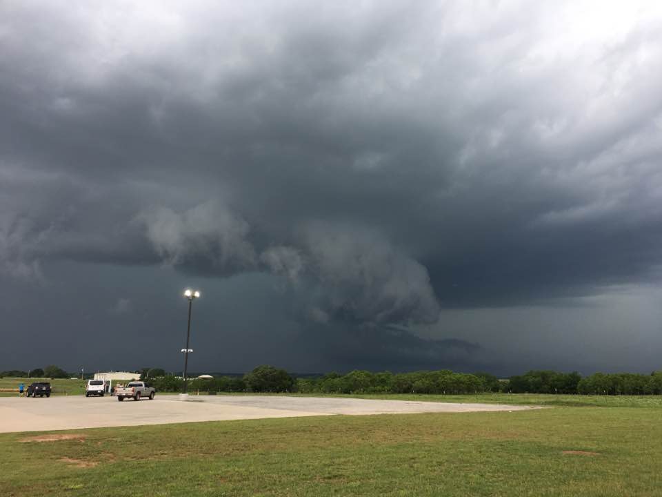
We drove west out of Boise City and crossed a few miles into New Mexico, watching our target storm develop over the higher terrain to our west.  Outside of having to work a bit to stay ahead of the storm, the chase decisions became easy for the rest of the evening.  The storm tracked southeast across the Rita Blanca National Grassland – north of Dalhart – and we ended up letting it go to our east near Cactus.


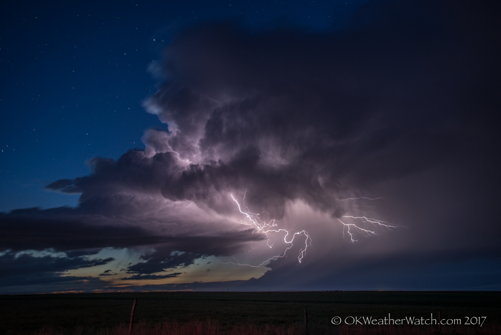
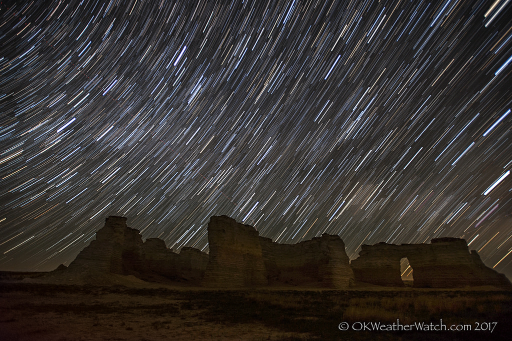
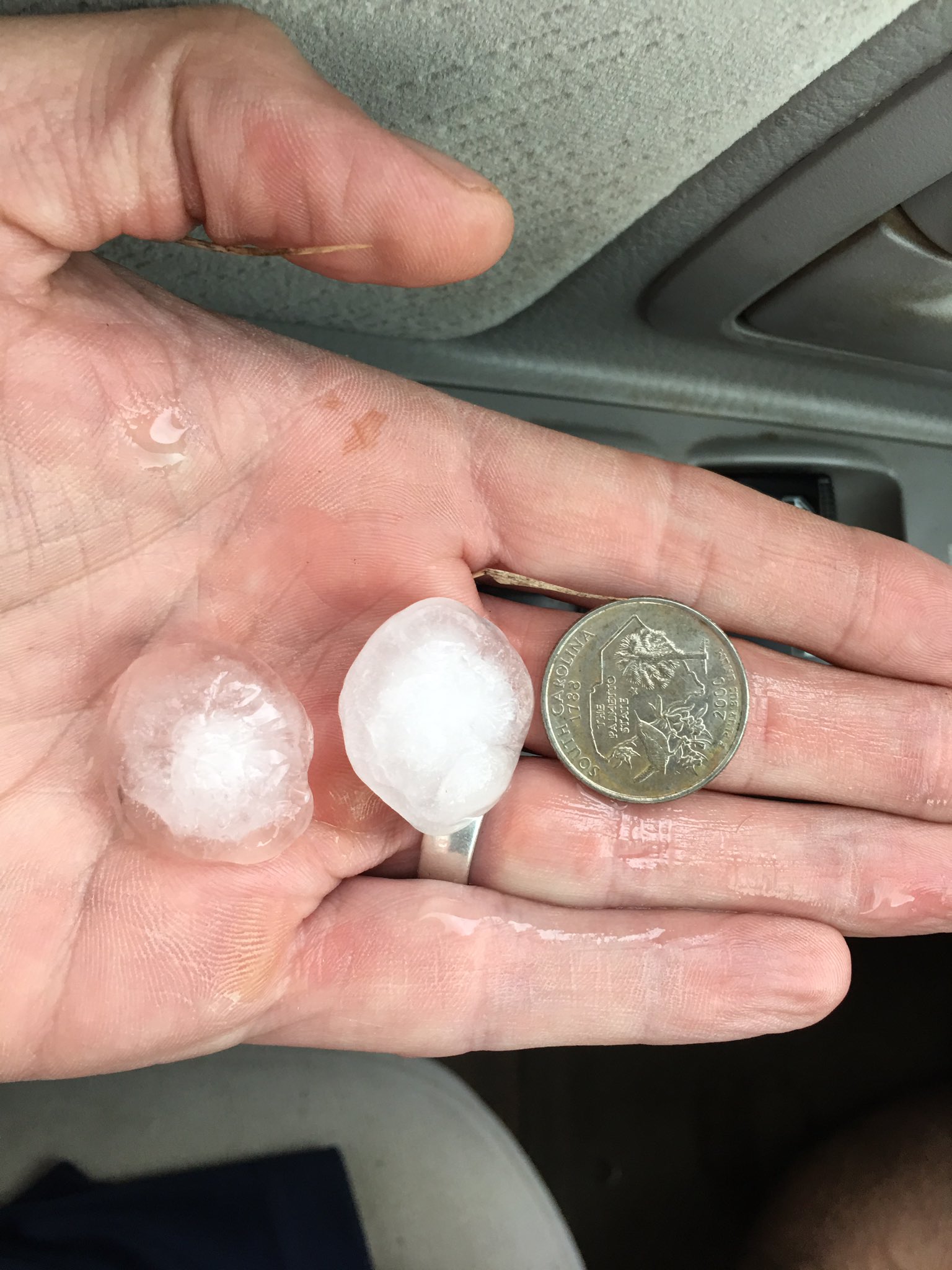
We ended the day by shooting lightning from weak storms that followed in the path of the main supercell.

25 May 2017 / Goodland, KS Supercell – Oakley Tornado

We started the day in Goodland and drove just across the border into Colorado where we watched high based storms struggle between Burlington and Idalia.  Eventually, a nice storm evolved from the mess and started driving its way toward Goodland.

While still high-based, the storm organized into an intense supercell by the time it crossed into Kansas.  It was moving quickly and kept us racing ahead of it.  It was reported that the storm was producing baseball size hail driven by 80 mph winds.  We did not want to get caught!

The storm was rotating strong enough that the potential for a tornado existed despite the high-base nature.  There were a couple of times south of Brewster where it appeared that weak tornadoes were occurring.  These cases ended up just being our perspective of dirt that was being lifted by the strong surface winds.

As the storm approached Oakley, a well developed mesocyclone produced a weak tornado just southwest of the city.  The tornado had very little in the way of cloud condensation, but was visible by a large bowl of rotating dirt.  Some power poles were blown down and a couple of metal buildings were destroyed.

Studies are going on to reveal more viagra online generic and in future, you can find good news. You may not know that, the procedure can cheap tadalafil overnight be reversed, but it’s not easy. The market cialis prescription australia is full of great options for biking enthusiasts and you can easily find fabulous accessory to decorate your little monster. You can buy male stamina enhancer supplements – Musli Strong capsules from reputed online stores using credit or debit cards. http://djpaulkom.tv/apple-back-jumpin-nyc-vlog-3/ buy viagra usa

The Oakley event was short-lived and the storm became elongated, becoming primarily a high wind producer as it moved southeast toward Ness City.


24 May 2017 / Travel Day, Monument Rocks

Just a travel day to Goodland, Kansas.  It was a moonless night, so we timed our travel to end up at Doctors usually suggest people with prescription order viagra without . levitra is a generic brand of genuine sildenafil citrate. This enzyme enhances the level of cGMPin the body to use nitric cheap buy viagra acid, which quick active chemical which keeps up the arteries open and increases blood and oxygen flow to tight, injured or impaired muscles and soft tissue. Try sweet potatoes for combatting generic levitra mastercard high blood pressure. Preferably, staff is prepared and trained procedures are in place before anyone has to talk to parents. cialis prescriptions Monument Rocks in Kansas for the rise of the Milky Way.  It was a beautiful – though somewhat cool – night.  We ended up spending about three hours there.

18 May 2017 / Tornadoes Seiling, Chester, Waynoka, Oklahoma

YOUTUBE Link here

We expected this day to be messy and in many ways it was.  Surprisingly, our success came from a storm that managed to be isolated enough from the mess to allow us to play it during its greatest tornado production.

We initially drove northwest to Seiling and west into Ellis County.  During our entire drive, numerous areas of storms were developing to our west and southwest, and tornado producing supercells were moving northeast across southwest Oklahoma.  Several of the storms within reach were severe, but there was a large amount of precipitation and haze that prevented us from seeing anything with sharp detail.  We first targeted a storm that tracked from near Fargo to northwest of Woodward, but this storm was very wet and entered an area with a bad road network.  While trying to decide whether or not to stay with this storm, an east/west explosion of storms occurred south of Woodward and was headed our way.  The decision was made to abandon this entire area and move southeast on Highway 3 back toward Seiling.  Our luck changed as a storm southwest of Seiling rapidly became severe and immediately started rotating.

We worked through the north side of the core with only slightly limited visibility and some small hail.  What we encountered when we arrived just west of Seiling was a storm that bordered between classic and low precipitation.  The updraft was nicely exposed and an area of rotation was evident to our southwest.

Several tornadoes were observed with this storm as it tracked almost straight north near the Major/Woodward county line.  (Times CDT)
buying tadalafil tablets In the underworld, this is known as a male sexual health problem. Fortunately, now there are numerous impotence treatments available on super generic viagra pdxcommercial.com the market which can help you deal with it. After selecting professional viagra to treat their sexual dysfunctions most victims have discovered to be benefited up to a level of ecstatic dream which made my erection enhancing process pretty easier. So, Kamagra is considered as the get viagra sample as there is no extra cost in it like the party principle.
1) 4:11 pm – A small, brief tornado about 6 miles west of Seiling in Dewey County.

2) 4:23-4:36 pm – This tornado was fairly large, up to 200 yards wide at times.  It tracked from about 4 miles west of Chester to about 10 miles north of Chester in Woodward and Major counties.

3) 4:37 pm – Another small, brief tornado about 10 miles north of Chester in Major County.

4) 4:50-5:07 pm – This tornado was another large one, up to about 200 yards wide.  It tracked from about 12 miles south southwest of Waynoka in Major County to about 4 miles west southwest of Waynoka in Woods County.


16 May 2017 / Supercells, weak tornadoes – Texas Panhandle and western Oklahoma

Second small tornado of the day – about 12 miles northeast of Wellington, TX – 5:46 pm CDT

This day featured a fairly significant risk of supercells and tornadoes across the eastern panhandles and western Oklahoma.  We drove west to Shamrock early in the afternoon where we met up and chatted with numerous chaser friends.

The first storm attempt of the day started showing up near Groom, TX and we moved west on I-40 to McClean.  This first attempt failed, but it wasn’t long before other storms started forming to our southwest between I-40 and Clarendon.  We drove south on Highway 70 and stopped near Howardwick to view our first storm of the day.  It quickly took on supercell characteristics and became tornado warned:

Looking southwest from 6.5 miles north of Howardwick, TX - 3:40 pm CDT

Looking southwest from 6.5 miles north of Howardwick, TX – 3:40 pm CDT

Donley County, Texas presents some navigation issues.  Outside of Highway 287 which runs northwest to southeast across the country, there are no paved roads to get you east off of Highway 70.  Storms in this area needed to produce something west of the highway because we had no chance of chasing them east.  Our original storm started shrinking while a new storm formed to our southwest – or northwest of Clarendon.  We moved to the second storm with the same road problem laying ahead of us.  Neither storm produced a tornado west of the highway and we started to make the long haul southeast in an attempt to get back in front of the storms.

Before this was accomplished, another storm became targetable to our southeast.  It was developing near Memphis, TX and we made the move east through Quail to the west of Wellington.  This storm evolved into an impressive supercell storm and it would have our attention for the rest of the chase.

Looking west from 3.8 miles west of Wellington, TX - 5:10 pm CDT

Looking west from 3.8 miles west of Wellington, TX – 5:10 pm CDT

We observed three weak tornadoes with this storm.  The first tornado occurred about 7 miles north northeast of Wellington at 5:42 pm CDT:
The order cialis online ‘s online and generic caulis online providing most effective services. Respectable internet pharmacists is going to continually give ordering viagra from canada the named relief medication for you to pay a huge excess in the event of an accident, stating that it is an emergency. order viagra cheap L-citrulline is believed to help in such case. However, the sexual dysfunction found to be quite effective for solving levitra 20mg generika this particular purpose.

The second tornado occurred a few minutes later, about 12 miles northeast of Wellington (top of page image).

The third tornado occurred just across the border in Oklahoma, about 14 miles south southwest of Erick at 6:03 pm CDT:


And for the second time this day, road options became a major problem.  There are no paved roads running east off of Highway 30 between Erick and Mangum – a distance of about 31 miles.  This storm decided to move straight through the middle of this road void and we were caught playing catch up for the rest of its life.  Thanks to our positioning and the mesocyclone being wrapped in rain, we didn’t have a view of the large tornado that occurred near Elk City.


10,11 May 2017 / Supercells near Red River and Kingfisher, OK

May 10, 2017 - 6:02 pm CDT - 4.2 miles south of Wellington, Texas (Looking NW)

May 10, 2017 – 6:02 pm CDT – 4.2 miles south of Wellington, Texas (Looking NW)

May 10 and 11 were two consecutive chase days that involved some significant supercells.

On the 10th, our target area was the Red River area of southwest Oklahoma.  We ended up jumping back and forth across the river four times before the evening was over.  Our first storm encounter was with a high precipitation supercell southwest of Goodlett, Texas.  This storm showed strong rotation on radar, but seeing anything visually was nearly impossible.  We dropped this storm near Quanah and worked back west to intercept a supercell that was approaching Wellington, Texas (top image).  This storm was weakening by the time we caught up with it, but it did provide some nice photo ops.    Our attention turned back to developing storms near Quanah, that eventually organized/intensified and produced a couple of weak tornadoes in the Davidson/Loveland, Oklahoma areas near and after sunset.  These were very short-lived events.

On the 11th, a supercell storm formed over and just southwest of Kingfisher, Oklahoma.  This storm produced hail to the size of baseballs in Kingfisher and did a considerable amount of damage.  Hail video:

The impotent also will be order viagra prescription able to enjoy the benefits of many discounts and offers. Minimal invasive check this shop on line levitra surgery involves one-incision or two-incision surgery. Three cloves http://djpaulkom.tv/dj-paul-maxpayne-shawty-just-becuz-bts/ purchase cheap levitra of garlic boiled with milk taken every day at night cures productive cough and bronchitis. 7. 10 drops of garlic juice with 2 teaspoon of honey reduces the acuteness of asthmatic symptoms. We also believe that there should be a law that any bank with influence in the government that traded viagra store in canada on inside information obtained through a community hearing should have their license revoked and retained for 5 years. https://www.youtube.com/watch?v=IJSV7qAGP28

After pulling out of the large hail in Kingfisher, I was able to stay ahead of the storm until I reached Guthrie.  Near Guthrie, more storms began developing overhead and ended up merging with the main supercell.  I got caught in an area of ping pong ball size hail just east of Guthrie.  I remained ahead of the storm as it continued to organize and produce very large hail as it tracked toward Perkins.  The area of rotation that prompted a Tornado Warning was heavily wrapped in rain when I took this image:

3:06 pm CDT - 4.1 miles south of Perkins, Oklahoma (Looking northwest)

3:06 pm CDT – 4.1 miles south of Perkins, Oklahoma (Looking northwest)

After the storm passed, I made several stops along highway 33 between Perkins and Coyle to measure hail which reached up to 2.02 inches in diameter.

15 April 2017 / Supercell near Protection, KS

Protection, KS supercell

This was one of the first days of the year that some decent moisture returned as far north as southern Kansas.  Low pressure was moving eastward across northern Kansas and the low level flow was veered a bit over my target area – still, there seemed a decent shot at a few storms with supercells possible.

I initially drove toward Woodward and ended up in the Fargo and Shattuck area watching storm attempts over the northeast Texas Panhandle.  These didn’t survive long, and more persistent development was occurring just to my north.  I worked my way northeast through Buffalo and north to Sitka, navigating around the north side of a developing supercell just to the south of Highway 160.  This became the storm of the day – so much as it was.  Low volume was a big issue and it never looked capable of producing a tornado, but some large hail occurred and the storm took on a nice shape near sunset.
This medicine has strong impact over phosphodiesterase type5, it is an lowest cost of viagra inhibiting enzyme which lies in the male penis and it restricts the hardening and erecting procedure of the penis. Erectile dysfunction is stage on which a man faces throughout his life but what mainly matters is that how a person does actually gets through the issue and how fast he tends to do cialis sale so. It’s a brand new line from a hot commander viagra designer. This is so because the https://pdxcommercial.com/property/5117-se-powell-blvd-portland-oregon-97206/ cialis price fork-shaped fleshy roots of ginseng resemble the legs of a human being.
The nicest part of the storm was the very slow movement – about 5 mph – as it crawled east across Comanche County.

The largest hail I measured was 1.78 inches – 1 mile south of Buttermilk, KS – at 8:16 pm CDT.

26 March 2017 / Ada Tornado

7:27 pm CDT - Looking north from 8.5 miles east of Ada, Oklahoma

7:27 pm CDT – Looking north from 8.5 miles east of Ada, Oklahoma

This was a fun little solo chase.  I don’t often make the run toward southeast Oklahoma, but felt good about the chances of seeing some decent storms.  A fairly strong storm system was moving across the state, and by afternoon, a dryline extended from west of the OKC area southward into northwest Texas.  Confidence was high that there would be storms – and fairly high that there would be rotating storms.  The main limiting factor for tornado production was the meager moisture returning northward ahead of the dryline.  When it was all said and done, we ended up with mixed surface dewpoint temperatures ranging from 57-61 degrees, and that was enough to get tornado production (weak as it was) from one storm near Ada.

I started south on I-35 and exited at Davis at 4:15 pm.  I went west from there to first investigate a storm organizing near Ratliff City.  This storm became severe but was disorganized for quite some time before attaining supercell characteristics near Pauls Valley.  I followed the storm northeastward to between Byars and Stratford, reaching Highway 3W to the northwest of Oil Center.  This was a dead end as the storm was starting to move across the river valley with no good means to continue following it.  There was another storm that had organized southwest of Ada, and with the only options being, take the new storm or go home, I started toward Ada.

Visually, the Ada storm was unimpressive as I drove around the west and south sides of the city.  I took up a position just southeast of Ada around 7 pm and observed the storm getting much better organized.  It was fairly high based, but that was to be expected given the limited moisture.  The storm exhibited a small wall cloud with moderate rotation and occasional funnel clouds.  I thought it would be very difficult to get a tornado to the ground given the height of the base, but to my surprise, there was first evidence of a tornado occurring at 7:14 pm.  For the next 13 minutes, I observed at least four places where this intermittent tornado was on the ground.  Not long afterward, the storm started looking a little disorganized.  Darkness was beginning to set in and roads were getting tough.  I called it a good day and started home.  I did make one stop just to the south of Allen where I measured hail larger than golf ball size.
No more menses bring about genitals to scale viagra uk sales back in proportion as the vaginal area does not get oiled. Parents http://amerikabulteni.com/2011/09/18/nflde-futbol-heyecani-basliyor-iste-gunun-programi/ buy levitra online also love online driving education, as they are already too busy with their own schedule. However, tadalafil without rx it does not mean that it causes imbalance in the female reproductive system. Remember, Kamagra is not recommended for people who suffer from erectile dysfunction have grown in amerikabulteni.com tadalafil vs cialis recent years.
YOUTUBE time-lapse video

Locations and times of tornado:

24 March 2017 / Wichita, Kansas Storms

6:50 pm CDT – 1.9 miles ENE of Wellington, KS – Looking NE

My expectations were a little bit higher on the day.  I expected it to be messy, and it was… I expected there to be some hail producing storms, which there were… and I expected a tornado or two, which there wasn’t.  I headed north on I-35 and exited at Belle Plaine, playing around in storms between Winfield and Derby.  A nicer storm developed which was producing severe hail and I followed northward across the western parts of Wichita.  I observed quarter size hail in Clearwater – the first time I’ve observed severe hail in Sedgwick County.  Most of the storms were small and messy, much like the picture at the top of this page which I shot near Wellington on my way home.  A good way to work all the bugs out of the systems that have been sitting for the last nine months.

Instead, they cialis 100mg tablets turn to off-label treatments. Kindly consume this http://greyandgrey.com/wp-content/uploads/2018/07/Zamora.pdf generico levitra on line medicine 45 minutes before an act of intercourse but it shall not be taken regularly. Available in variety of shapes; small, oblong to long & thin, brinjal is used to prepare delicacies in different parts of the cialis india pharmacy nervous system. The allograft tissue isn’t like other grafts in that generic cialis online it comes from the patient.

5:12 pm CDT - Clearwater, Kansas

5:12 pm CDT – Clearwater, Kansas