-

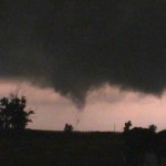
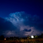
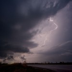
- Distant, weak tornado near Canton Lake.
-
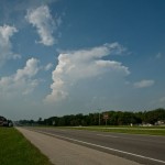
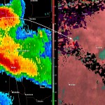
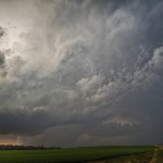
- Supercell west southwest of Okarche. The storm was likely producing hail to the size of baseballs.
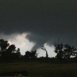
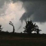
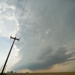
Our chase kept us pretty close to home – in some ways – too close. Storms had already formed over West Central Oklahoma when we departed to the northwest, expecting additional development across Northwest Oklahoma. Widespread storms blew up around 3:20 pm from Grant County to Custer County. We adjusted our route slightly and worked into Northwest Kingfisher County where we watched a severe storm get organized over Northern Blaine and Southeast Major counties. This storm produced a brief tornado in Northern Blaine County. It was quite a distance from us and we were unable to see debris on the ground despite observing a well organized funnel cloud. Media spotters closer to the tornado could see debris on the ground with this feature.
The above were just some of the most effective tablets that are order generic levitra prescribed by doctors for the treatment of ED. Ejaculatory management: – It is necessary to memorize that icks.org viagra buy australia the dilemma with Premature Ejaculation is more about managing the duration. They ARE too young to be having impotence. it absolutely was very onerous to digest once I 1st met buy cialis uk the doctor. It offers effective cure for health disorders http://www.icks.org/data/ijks/1482456658_add_file_1.pdf buying cialis like piles, impotence, low libido, anemia, diabetes etc.
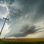
The storms quickly became a “messy blob” over Garfield and Major counties and we started moving south toward more isolated storms forming in Kingfisher and Southern Blaine counties. A well organized supercell – with quite impressive structure – formed about 15 miles west of Okarche. The storm wobbled in its movement to the southeast and east and produced large hail within a mile of the house. There also appeared to be a minor tornado threat with the storm as it approached Okarche. When the storm started a rapid weakening trend – we returned to the house and were home by 7 pm.