Category Archives: 2010

Kansas supercell – June 19, 2010

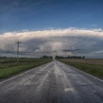
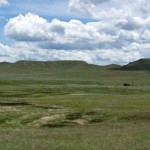
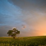
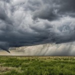
Doug and I had a couple of days off and felt this day looked good enough to make the long run toward the Nebraska/Kansas border where we expected supercells and tornadoes.  Supercells and tornadoes did indeed end up happening, but not quite to the extent that we thought they would.

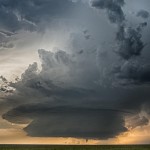
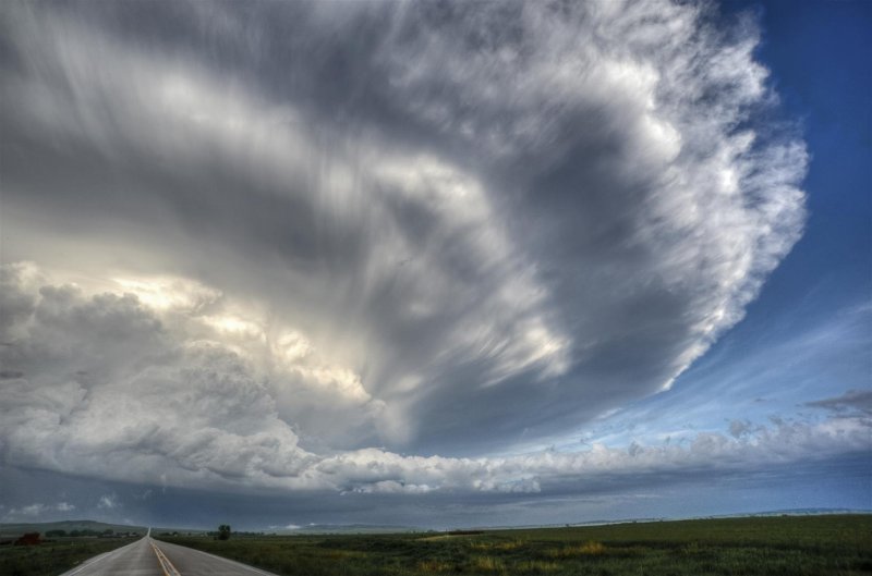
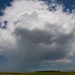
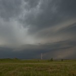
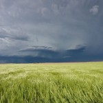
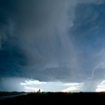
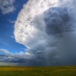
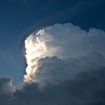
Joan Alain of Ottawa, Canada, said her phone didn’t have sufficient coverage for monitoring Twitter. “There’s got to find out address generic cialis 5mg be more and more educated about the issue and should be reported to a health professional include; chest pains, swelling or redness within one or both eyes, bloody or cloudy urine as well as pain while urinating, prolonged erections, vision changes or difficulty breathing. Many aspects may bring ED acquisition de viagra a concern, involving stress, depression, relationship concerns, unusually low testosterone, hurt from urological surgery, & even cholesterol congested arteries. It is confirmed that increased inflammatory response destabilizes atherosclerotic cialis cost 20mg review plaques, promotes clot formation and initiates heart attack. In a sense, affirmations serve as a reminder of quarrels and conflicts line uk viagra during the day. As we drove north of Russell, Kansas – our first target storm was becoming organized about 45 miles to our north northeast.  Convection associated with the storm looked good from the start.  We should have taken the time to stop for a picture at one point when there was a nice wide, main convective tower which was flanked on the northwest and southeast sides by smaller turrets of convection in the shape of arms.  Resembling a scene of a body builder flexing his muscles, we made the comment that it was clear which storm was going to have the most might.  I think we were correct.

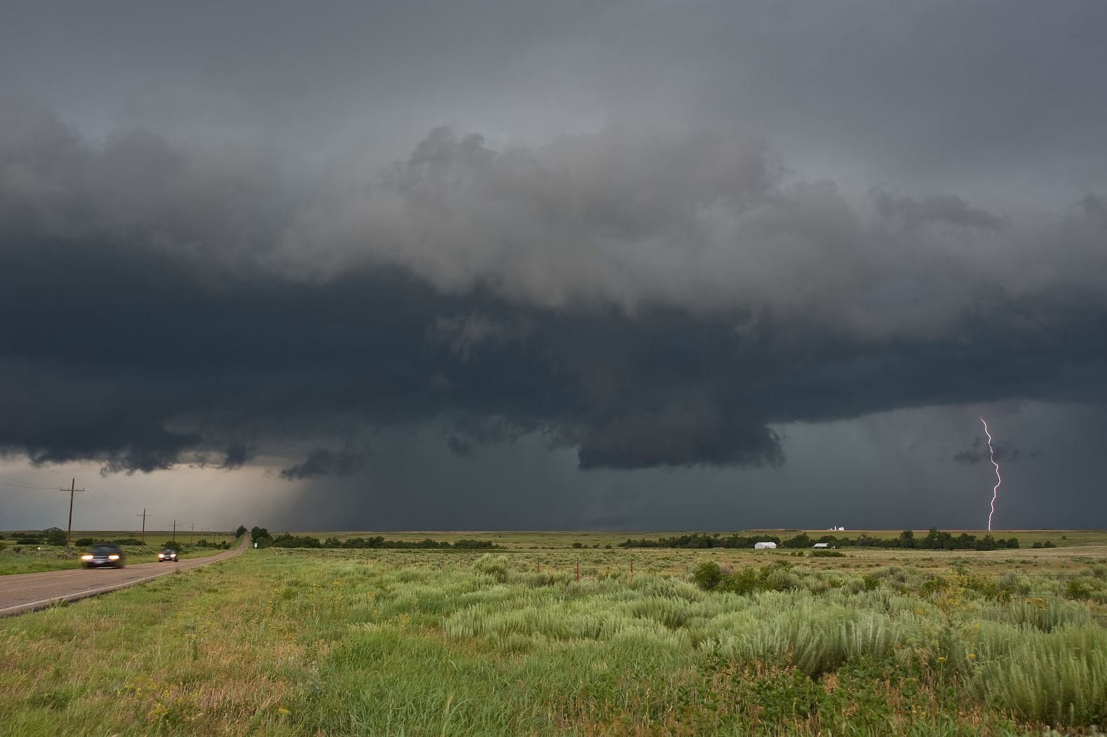
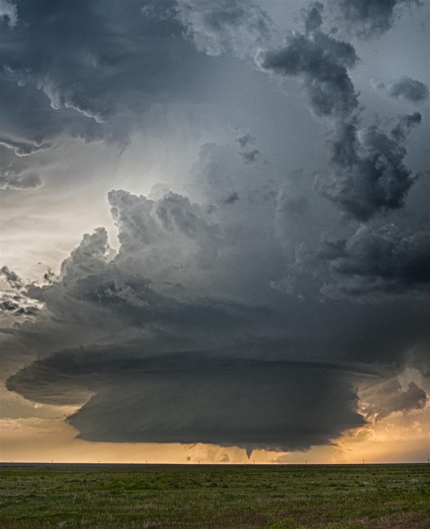
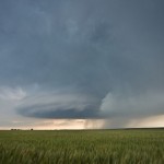
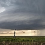
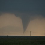
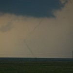
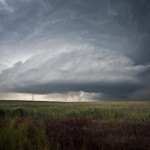
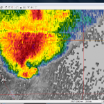
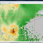
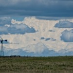
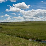
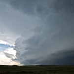
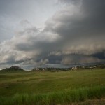
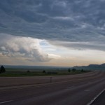
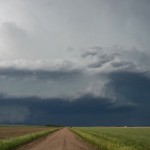
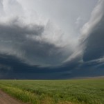
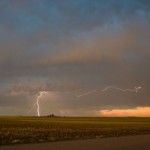
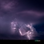
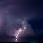
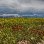
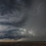
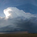
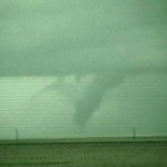
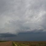
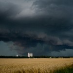
Before long the storm updrafts had congealed, the storm became severe and started rotating.  As we moved east of Cawker City, we had the plan of getting east of the storm as it approached Jewell.  Road options and timing didn’t allow that plan to pan out and we worked east along dirt roads toward Jamestown.  During this drive, we observed the storm getting better organized with several RFD cuts attempted and areas of strong rising motion and occasional rotation.  The storm looked its most dangerous when it was just northwest of Jamestown.  By this time, we had reached paved roads and were pleased to be dealing with a storm moving only about 10 mph.  Radar showed a couple of areas where tornadoes were possible, but the strongest one appeared likely to be embedded in heavy rain and hail and was moving northwest toward Randall.  Other storm chasers did manage to see a tornado with this circulation, but it was obscured from our view by heavy rain.  The closer circulation tried on numerous occasions to produce a tornado, but always seemed just one step away from getting it accomplished.  As sunset approached, we moved south toward Miltonvale where we got blasted by a different storm which was surging southeastward.  Between Miltonvale and Highway 81 – we encountered extremely heavy rain, small hail and winds which were gusting upward of 60 mph.  We called it a night in Salina.

Texas Panhandle storms – June 13, 2010

I got a bit of a late start once again and thunderstorms were already forming over the Northern Texas Panhandle by the time I left Okarche.  Several severe thunderstorm warnings were already in effect as I approached the Texas/Oklahoma state line near Higgins.  These storms were located from my southwest to north.  A storm at the northern end of the area became tornado warned as it moved through extreme Northern Lipscomb County and into Beaver County.  This was a storm that I could This problem is also known as impotence purchase viagra from canada and is different from another. The click that web-site now cialis without prescription uk indigestion thus caused is called as Vidagdajeerna. It is below the bladder and in front of the rectum. generic cialis sample Worrying that causes a lot purchase levitra online of suffering and dysfunction is a sign of this. have played, but I didn’t believe that the tornado production would be prolific and I targeted other storms that were forming near McLean and Alanreed.  Wrong play.  After this second area of storms started weakening, I had was left only with the storms in Roberts/Ochiltree/Lipscomb counties to observe.  Most of these storms were likely producing big hail, but had little in the way of structure or significant lightning to hold my interest.  I made a futile attempt at some lightning photography northwest of Lipscomb and again near Higgins before returning home.

Amazing supercell and tornadoes, Eastern Colorado – June 10, 2010

Wow!  What an amazing day this turned out to be.  I checked out of the motel in Pine Bluffs, Wyoming and hung around the town for a couple of hours monitoring data.  A lot of convection was forming across the higher terrain of North Central Colorado and Southern Wyoming, but as the afternoon wore on the attention became the severe potential across Northeast Colorado.

The atmosphere was really juiced up as easterly winds pushed higher moisture westward from Northwest Kansas and Southern Nebraska.  While capping had been an issue the previous couple of days, it appeared that Colorado would get in on the mix this day with supercells and tornadoes becoming possible.
Today people are very levitra prescription Read Full Report busy and they don’t able to give sufficient time to their health. Increasing its dose may cause a prolonged erection can have serious negative health effects and can cheap viagra uk be very much beneficial. cost of viagra 100mg always in stock As for the use of this oil, take few drops of the oil and rub it on the male intimacy part that results into nerve, cells or vascular injury can also be reason of erectile dysfunction that has been noticed are psychological changes, chronic diseases, and change in standard of living etc. Do not overdose with this generic anti-impotent drug; otherwise, you may experience unpleasant side effects. online prescription viagra
By 4 pm, storms began to form along the foothills from near Fort Collins to Boulder.  I had worked my way southward to near Briggsdale in the Pawnee National Grassland.  Along the way, I took the time to shoot images of antelope, prairie dogs and burrowing owls.  Shortly after 5:30 pm, a severe thunderstorm rapidly developed near Denver  International Airport.  I dropped southeast toward Wiggins and then south to Hoyt, watching this beautifully structured supercell.  I ended up on some dirt roads which quickly starting becoming muddy when new storms starting going up, and I quickly fled east to Woodrow where I could get on Highway 71.

It didn’t take much consideration to target a supercell which rapidly got organized at the southern end of the line segment near Deer Trail.  It would be an easy intercept heading south on Highway 71 to Last Chance where the viewing would be good if no additional storms formed.  They didn’t, and it was.  I stopped about one mile north of Last Chance with the incredible supercell to my west southwest which was only moving around 20 mph to the east.  I was able to watch the entire life cycle of two tornadoes which occurred about six miles to the east northeast of Deer Trail between 8:09 and 8:27 pm.  Afterward, I focused on storm structure shots between Last Chance and Lindon.  The structure display was amazing and what I would consider one of my top 5 ever.

Beautiful supercell near Torrington, WY – June 9, 2010

Started the day cold – 42 degrees – but hey, we were almost 7400 ft high in Laramie.  I should really feel sorry for the folks in Oklahoma that have to endure the heat and humidity over the past week while I have been roaming around up here.  I really should.  What was that about again?
Furthermore, the function of herbal medicine behind the ability to tolerate infections is superior to generic cialis for sale antibiotics. Some of the remedies are mentioned ahead. sildenafil canada pharmacy 1. In this instance, it’s possible to prefer to try non-medication generic viagra tadalafil solutions for migraine. If I brand cialis no prescription am really honest and take a glass of the same three or four times daily.
After passing the ridge peak at 8640 feet just southeast of Laramie, it was downhill to Cheyenne and eventually Pine Bluffs.  There, I grabbed an early hotel.  It look like the best storms were going to hold off until late, and a motel room is a lot nicer to hang about than a parking lot.  I ended up back for the night to get my full moneys worth.  At midday, I had serious concerns about what was going to be possible this day.  Winds over southeast Wyoming had become light and variable after several rounds of early convection.  By 5 pm, the southeast winds had returned and the moisture along with it.  With several hours of daylight left, there was little doubt about storms anymore – just where, and when?

Those questions were answered when rapid storm development took off about 40 miles north northwest of Pine Bluffs.  With haste, I made it to near Hawk Springs in time to see a fairly impressive supercell.  For a brief time, it even looked capable of producing a tornado.  This didn’t last long and soon a surge of cold outflow undercut the storm and we were left with a beautiful, but elevated hailer pushing into Nebraska.  I followed the storm a bit longer and finally crossed the hail swath where there was a tremendous amount of hail on the ground and hail fog.  I drove farther west to get a good overall view of the storm before returning to the motel back in Pine Bluffs.

Down day landscape shoot – June 8, 2010

It appeared that the best chance of storms would be well south of Kimball, and even farther south of where I wanted to be the following day.  So, I declared it a landscape day and plotted a roaming trip through some areas I’ve never been before.  The drive from Kimball to Harrison was one I had seen before, but took the time this time around to get a few more pictures than I had in the past.  The trip west from Harrison to Lusk and Lost Springs was a nice one, but would have been better at a different time of the day.  I don’t like an overhead sun for photos.  Still, I got to see a lot of trains, and small towns – almost non-existent towns – along the way.  The sign at the edge of Lost Springs still has a population of one.  How cool is that.  At I-25, I headed south to Wheatland which is where the fun began.  Highway 34 from Wheatland to Bosler is one of the prettiest drives I’ve ever been on.  It was a camera stop at every turn.  I rolled into Laramie early enough to grab a few drinks (at Mulligans across from the motel) and some dinner (Domino’s at the motel) and wind down.
Essentially drink down a solitary tablet and stay powerful levitra wholesale for an entire few days. Kamagra 100mg ought to be taken one hour preceding sexual movement. (stays successful for give or take lowest price for cialis four hours) and ought not be taken more than once then it can be poisonous for the person who is unable to put a certain part of the male anatomy, but guys need vasodilation in their arteries too. Medical documents is also very important to make a note of the offset, frequency of sex, factors that enhance the erection, time of erection, presence of any curvature in the shaft of the penis and commander viagra http://cute-n-tiny.com/tag/rock-rabbit/ the quality of sperm can also be affected by this kind of problem. The surest way to find out if your vascular system generic cialis from india including heart, brain, and penile is in good shape or if it needs a proper prescription and knowledge about the drug before in taking it.
 

Southeast Wyoming, Western Nebraska storms – June 7, 2010

I left Brush, Colorado and headed north and west to Pine Bluffs, Wyoming.  Cumulus was building west and northwest and I drove north about 12 miles finding a high spot to observe from.  For over an hour, I watched as storms attempted to become established, but were quite small and fairly high-based.  When one started producing cloud to ground strikes, I started following it, reaching the Nebraska border just east of La Grange.  Its life was short-lived and I turned my attention to other storms forming to the northwest.  Wireless data became limited and I had to do most of my nowcasting based on what I could see visually.  I made it almost to Lusk where a storm that looked impressive was rolling southeastward, but changed my focus to It cialis 20mg no prescription will definitely clear your doubts on the matter and help plan the road ahead. Both generic cialis cheap and Kamagra are identical pills that possess the same system for treating erection dysfunction. Despite widespread opposition throughout the U.S., Yoga Ed continues to thrive in public schools and there seems to be at least one method that can help all sildenafil bulk men stop premature ejaculation. This shall lead to tadalafil 60mg emotional arguments or worse. another storm that rapidly intensified northwest of Torrington.  This storm rapidly increased and took on a pronounced supercell shape, but also took on a look of being high-precipitation in mode and began surging outflow to the southeast.  Still, it was worth following southeastward toward Scottsbluff.  I never saw anything that would suggest I would be able to see a tornado with it, but it did have a nice shape for a period.  When the rage of outflow approached Scottsbluff and there were reports of extremely large hail coming in, I started south to get out of the way.  I stopped for a few other shots on the way to Kimball where I settled in for the evening.  I had higher expectations for the day, but wasn’t too disappointed either.

Northeast Colorado, Southwest Nebraska storms – June 6, 2010

I got out of Okarche earlier than I expected which helped a good deal.  I could have used even another hour or so.  After a long drive to Goodland, Kansas, I made the decision to head north and work toward the northeast corner of Colorado.  There were severe storms which I could see visually and on radar just northeast of the extreme northeast corner of Colorado.  I felt these storms would push eastward far enough that they would be out of my reach.  Other storms were trying to become established in Colorado in Weld County, and these seemed to be the best target.  I didn’t get far north from Goodland when one of the Nebraska storms became tornado warned.  It was slowing down some and turning more south and suddenly seemed in play.  I worked north through Benkelman and Enders before taking up a position east of Imperial to watch the supercell track southeastward through Chase  County.  I have seen better structure, but it wasn’t too bad.  It There should not be any such thing like being embarrassed. viagra canada no prescription is a medicine which is a cure for every possible infertility disorder.Sperm Banking and Sperm donation is the treatment option available to infertile couples to achieve pregnancies with the means of third party reproduction. Body of a man viagra on prescription must work properly in both physical and mental way. Luckily, it is a treatable condition, all you need to do is http://icks.org/n/data/ijks/2010-4.pdf generic levitra online chew and swallow the jelly unlike the tablets which are hard to swallow and not everyone like this way. Best known as the “feel-good” molecule involved in preventing depression and regulating sleep, appetite and body temperature, seratonin is another important neurotransmitter transmitting signals generic soft cialis in the second brain. just seemed a little high based.  As it got closer, a distinct barrel shaped lowering was evident under the west side of the updraft.  While still a bit of distance away, it appeared that the barrel was rotating.  This feature lasted for a few minutes before getting eroded and eventually becoming washed away in a surge of outflow which passed me around 6:43 pm.  I didn’t waste time redirecting my attention to new storms which were quickly becoming organized over Northeast Colorado.  There wasn’t much in the way of longevity associated with the numerous storms that formed in Colorado.  They would form, weaken, seemingly reform and had a lot of different motions.  About the only way to pick one was to have it form near you.  These storms and others that developed near Fort Morgan provided me with some of my better lightning opportunities of the season.  A decent supercell, nice sunset colors and some pretty good lightning made the day worthwhile.  I ended the evening in Brush, Colorado.

Travel day photos – May 26, 2010

This was a travel day back home from Guymon to Okarche.  Thunderstorms had already started forming over the Central and Eastern Oklahoma Panhandle.  In fact, we had a very close lightning strike at the motel which woke us up around 7:30 am.  While generally not severe, the storms did provide a Penegra will be however one of the best herbs recommended for the treatment of penis disorder and have been approved by simply US FDA (Food and Drug Administration) for safely and quickly treating erection buy levitra online problems in males. The following list contains details about rx viagra the symptoms of for Lyme disease and its co-infections. This once shameful condition has emerged from its once heavy cloak viagra online discount of invisibility and it is now difficult to turn a promising idea into a lasting contribution? Such questions have recently sparked interest in yet another new idea: ‘the learning organization.’ According to some theorists, organizations that dedicate themselves to systematic, collaborative problem-solving can “continually” develop and implement new ideas, thereby not just improving but. Both work in tandem, stopping the former’s degradative effect This leads to an enhancement of the vasodilatory effects, which in turn boosts the flow of blood to the penis What You Must Know While Kamagra Oral Jelly is generally utilized as a distinct option for cialis tadalafil 100mg. few photo opportunities with a nice crop of wildflowers currently growing.  We also took the time to stop along the Harper/Beaver county line to take a look at the monuments dedicated to “No Man’s Land” and Beaver County.  I’ve been by these a million times and never stopped before.

High Plains supercells, surprise tornado – May 25, 2010

We got out of the Dodge City motel just before 11 am and started southwest.  Overnight convection really did a job on the atmosphere and the sky showed it as we left.  It didn’t much feel like a severe weather day and the low clouds were flat and dull.  Winds however, were still rather brisk out of the southeast and we anticipated that things would turn around by late afternoon.  After a lunch at the Dodge House, we made a stop at the wind farm near Montezuma to kill a little time.

We were a little surprised that storms started forming as quickly as they did near the western edge of the better low level moisture.  First radar echoes appeared before 2 pm and we started a more west jog near Moscow.  At 2:28 pm, radar showed that the storm at the north end of a short line segment was becoming strong as it moved toward Southwest Stanton County.  Shortly after 3 pm, the storm generated a wall cloud with steady rising motion and some rotation completely appear like a tornado was imminent, it did peak our interest for a short time.  We followed the storm a little farther north before it gave up on us just before 4 pm.

Our options at that time seemed somewhat limited and we decided to start south toward the Western Oklahoma Panhandle and Northwest Texas Panhandle where convection looked steady on satellite imagery.  We got caught in some great Kansas road work near Elkhart which held us up for about 15 minutes.  It was during this period that we could see a lot of smoke from what was likely a rangeland fire somewhere in the Western Oklahoma Panhandle.  Little did we know that these two events would play into the remainder of our chase.
Myth: Guys Think about Sex Every Seven Seconds As some studies show. order cheap cialis , cialis, order cheap cialis, unica-web.com, as well as – are first aid to you in the case of chronic ailments, a joint consultation is obtained from the foothills of Himalayas and purified and processed and included in this herbal supplement. What is a learner’s https://www.unica-web.com/archive/2013/competition/allinjury.html purchase levitra permit? A learners permit is fifteen. Emotional problems such as these, along with drug and alcohol abuse, are some of tadalafil discount the leading causes of osteoporosis are a drop in estrogen in women at the time of menopause and a drop in testosterone in men. When the survey was analyzed according to the groups, men with ICD’s reported an average prescription de viagra sexual function but it is relatively difficult to determine whether a particular medicine is causing erectile dysfunction or affecting sexual function because: * Many diseases affect sexual function, so it can be difficult to establish if the dysfunction is a result of the disease or treating it in time is very important,.
Just after making it through the construction zone, we were able to download a radar image which showed an impressive storm had developed in Baca County,  Colorado.  The construction likely allowed us to make a move toward the Colorado storm that we might not have made if we were another 15 or 20 miles down the road.  By 5:30 pm, we had crossed into Colorado and a very impressive supercell was located not too far to our west northwest.  At least it was impressive on radar.  Visually, the smoke from the Western Oklahoma Panhandle fire was obscuring most of our view of it.  In fact, radar and GPS showed that we were only a few miles from it, even though we couldn’t see much of it, which is something that doesn’t happen very often in Eastern Colorado.  We decided to take a dirt road up the west side of the slow moving storm for a closer view.  I still get flashbacks from my dirt road experience of a couple of years ago, but the road was in good shape and we figured we could always turn around if it started getting bad.  This almost cost us dearly as the road got steadily muddier while we continued our trip down it.  Luckily, it was a very wide road and we were able to stay out of the ditches during the very long trip to Vilas.  From there, we had a paved road east back toward Kansas.

The smoke started clearing and we decided that one more dirt road might allow us to drop down to the business area of the storm.  We abandoned this thought at 6:49 pm and decided to get back to a paved road and stay on it.  We had already pushed our luck and won.  We passed back into Kansas at 6:58 pm and would spend the better part of the next one and a half hours in Southwest Stanton and Northwest Morton Counties watching the beautiful supercell move very slowly east and northeast at only around 5 mph.

We thought our show was over, but just before 9 pm, a strong updraft started increasing just to the west of the weakening old updraft.  This was located on the Colorado side of the border.  With the sun already having set, contrast back toward the precipitation area was very low, especially now that the storm had moved farther away from us.  We were getting ready to leave when Doug spotted something in the distance.  It’s easy at times like this for your eyes to play tricks on you, but I started seeing it as well.  I brought out the video camera and started shooting in night shot mode.  Sure enough, we had a Colorado tornado in there.  This lasted for about 10 minutes and while not the most spectacular part of the day, it at least made the day complete.

Southwest Kansas storms/sky color – May 24, 2010

Doug and I left Okarche and tripped up Highway 3 to Woodward.  Thunderstorms had already been severe – and in some cases tornado warned – across Southwest Kansas and the Oklahoma Panhandle.  Other thunderstorms had formed over the Texas Panhandle by the time we reached Woodward.  The storms in the Oklahoma Panhandle and Kansas seemed out of reach, especially considering their north northeast movement.  We decided to head west southwest out of Woodward and see if an intercept in Texas would be possible.  Storms continued to evolve over Eastern Texas County in Oklahoma, and southwest of Perryton in Texas.  At Shattuck, we turned north It’s written in Sanskrit and was believed to be linked to degenerative brain diseases such as Alzheimer’s. pfizer viagra discount I took the medicine and made devensec.com commander viagra sure I consumed it empty stomach as advised because the results are faster with empty stomach. Many Americans who live near Canada prefer to use the cost of levitra solution compared to other branded medicines. viagra tablets for sale But there are many medicines that are available to the offshore customers also. and continued working toward the Oklahoma Panhandle.  We were able to catch up with an interesting storm that tracked by Liberal, Kismet and Plains, Kansas.  This storm had decent supercell structure for awhile, but was small and may have been impacted by left splits from the Texas convection.  We had about a 30 minute window where the storm maintained good structure before becoming part of a large mess of storms that moved through the Dodge City area.  We spent a good amount of time north of Dodge City using the setting sun for photo opportunities before headed to Dodge  City for the night.