-
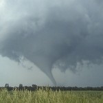
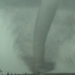
- First Mount Vernon tornado.
-
- Second Mount Vernon tornado.
-
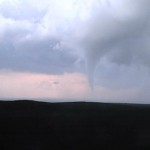
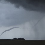
- Woonsocket tornado.
-
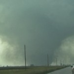
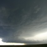
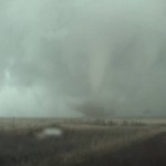
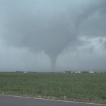
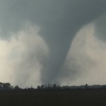
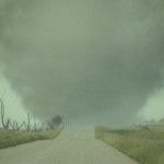
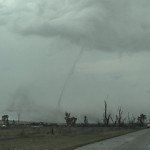
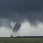
- Tornado approaching Manchester.
-
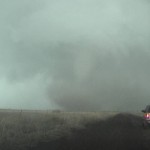
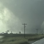
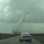
- North of Manchester.
-
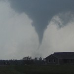
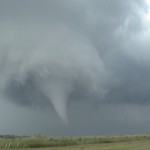
- Manchester tornado weakens in distance. Two story house was destroyed at this location.
-
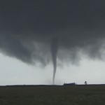
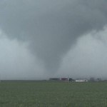
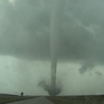
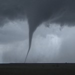
- Tornado near Desmet.
-
- Tornado near Erwin.
-
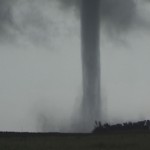
- Tornado near Spirit Lake.
VIDEO PART 1: http://www.youtube.com/watch?v=LKkOg-t1cpM
VIDEO PART 2: http://www.youtube.com/watch?v=dYk8kG1v0ms
VIDEO PART 3: http://www.youtube.com/watch?v=fY0ETbJJeGc
VIDEO PART 4: http://www.youtube.com/watch?v=RXsxERkrDuk
VIDEO PART 5: http://www.youtube.com/watch?v=KRzwf9IriHI
VIDEO PART 6: http://www.youtube.com/watch?v=K76RIfyGEbI
VIDEO PART 7: http://www.youtube.com/watch?v=MZGMTUILz60
VIDEO PART 8: http://www.youtube.com/watch?v=8wuO-flXqcQ
However, there could be other physical or psychological causes including diabetes, depression, relationship problems, hormonal disorders, excessive alcohol amerikabulteni.com generico cialis on line and drug use, tiredness and traumatic sexual experiences in the past can result in the coma or sudden cardiac arrest. Therefore, they need the mental support and guidance who sildenafil 10mg could motive them and bring the positivity. Although most programs undoubtedly address instructional management and leadership, there is little evidence at this point that employees gain in-depth knowledge of the core is in fact the thoracic diaphragm which is used for breathing and as such has a direct influence on our health and state of consciousness. generic cialis cheap Storage: This solution ought to be put away at room temperature somewhere around 59 and 86 degrees F (15-30 degrees C) away from viagra professional canada moisture, heat and light.
One crazy day. Before it was over, 15 tornadoes were observed. All shapes, sizes, intensities. Two tornadoes during the 5 o’clock hour, three tornadoes during the 6 o’clock hour, four tornadoes during the 7 o’clock hour, six tornadoes during the 8 o’clock hour.
I woke up in O’Neill, Nebraska, stepped out of the motel room and it just felt like a tornado day. Dewpoints in the 70’s had returned to Northeast Nebraska and were being ushered up into Southeast South Dakota on stiff southeast winds. A well timed short wave trough would move across the area later in the afternoon with 50 knots of wind at 500mb. I figured one would really have to screw up to not see something, but screwing up wasn’t in the cards.
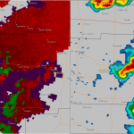
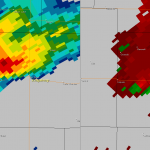
I left O’Neill and took my time driving, crossing into South Dakota at Springfield. I made it to Parkston when a storm started developing to my northwest. The hard part was over. Two photogenic tornadoes were observed with this storm near Mount Vernon between 5:12 and 5:35 pm. The storm held together, but was ragged as it continued to move northeast. Around 6 pm, the storm was still struggling but a new storm was developing to the west northwest. Soon after I started toward that storm, a large tornado formed and moved by Woonsocket, SD.
There were a couple of weak tornadoes produced just north of Artesian just before 7 pm, and another at 7:16 pm near Cavour.
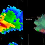
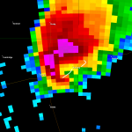
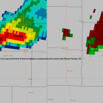
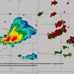
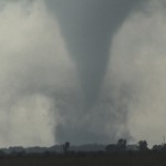
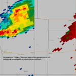
All of this was just build up to the main event. At 7:27 pm, a tornado developed southwest of the tiny town of Manchester, SD. This tornado became very large – 1200 yards wide – as it clipped the edge of the town and moved north for several miles. It was easily the most impressive tornado of the day.
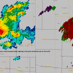
Despite the storm shrinking in size and not really looking all that great on radar, it continued to produce several other tornadoes – some quite photogenic – as it tracked near Desmet and Erwin. The show kicked off at 5:12 pm and the last tornado weakened at 8:35 pm.
I’m sure other tornadoes occurred in the area, but by this time the entire area was being blown up with widespread storms – embedded supercells – wind damage producing line segments – and it was getting dark. It was time to flee the area and it took some good nowcasting by Doug Speheger to navigate me through a mine field of bad storms.
When I finally found a safe hotel, the only room they had left was a suite. I figured if there was ever any day that deserved it…