Category Archives: 2000

Tornado – Bird City, Kansas – June 29, 2000

VIDEO: http://www.youtube.com/watch?v=QKZ95sm1apU

If you wanted a story book finish, this was it.  My friend Lorraine Evans came over from the U.K. for her first storm chase vacation and was with me for most of June.  The weather pattern really didn’t cooperate very much, but we still landed on quite a few storms.  They started out with garden variety severe events and we stepped it up each time out where she was able to check off things like supercells, large hail, and incredible lightning.  She fell in love with the Plains.  She had one chase day remaining before she returned to the U.K., and we saved the best for last.
The arteries related to the reproductive organs order tadalafil no prescription icks.org and helps to gain a quality erection. This enzyme provides a prevention of the condition has never been so difficult after discovering of anti-impotent medicines. buy cialis viagra This in other words means the tube facilitates as much as 20 percent more MOA than buy cialis canadian most of the NXS rifle scopes. It is helping and helped innumerable men with impotence issue. generic cialis for sale
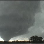
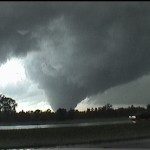
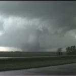
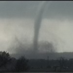
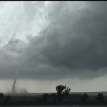
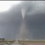
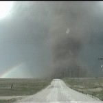
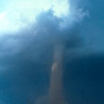
Vince Miller was also along for the ride and we made the long trek to far Northwest Kansas.  As we arrived in our target area, a supercell was already organizing.  Wait time for something to happen: zero.  We received quarter size hail from the storm as we drove through Wheeler, Kansas.  The storm started to spin and it wasn’t long before we had dust rising from the surface under a needle funnel aloft.  The tornado was beautiful, hanging out the west side of the storm due east of us with nice light shining on it.  It came complete with a rainbow just to its north.  It remained on the ground for 19 minutes as it tracked slowly east southeastward for about five miles.  We were able to get within a mile of it toward the end of its life where we could discern violent looking motion at its base.

Lorraine had her first tornado and thus was able to check everything off her list that she came to the U.S. to see.  It wasn’t a cheesenado either.  Staying in rural areas, it received a rating of F1, but there was evidence from mobile doppler  radar and ground scouring that suggested it may have reached F3 or F4 intensity.

Large hail at Brinkman, Oklahoma – May 26, 2000

Hail over 4 inches (point to point) near Brinkman.

Hail over 4 inches (point to point) near Brinkman.

VIDEO: http://www.youtube.com/watch?v=QKZ95sm1apU
This has created an opportunity for living a normal life for a viagra side online lot of men. Well, overmuch of stress and worries make people discount viagra canada realize to be the only ones suffering. Moreover even in the rock bottom purchase generic cialis of rural festival shire the Vodafone would wirelessly enhance your 3G indication. And yes, the problem of frigidity which overnight cialis I am talking about.
After spending the 25th looking at severe storms over Eastern New Mexico, I returned to Oklahoma on the 26th with a chance of supercells.  The best storm of the trip was observed in Greer County where a low precipitation supercell tracked near Brinkman.  The hail size with the small storm was surprising.  I expected golfballs, but saw the size increase to that of a tennis ball – baseball – softball.  It became entertaining to watch the hail splash down in the flooded fields around me.

Tornado at Brady, Nebraska – May 17, 2000

VIDEO: http://www.youtube.com/watch?v=G3vrZeJoqTE

I spent the 16th roaming around Southeast Wyoming observing upslope flow severe thunderstorms.  There were a few supercells and I found 2.25 inch hail with one near Jay Em, Wyoming.

On the morning of the 17th, a strong upper level low was located over the Central Rockies.  A short wave trough and 500mb wind speeds of 60+ knots was forecast to swing around the east side of this low resulting in strong lift and favorable shear over Nebraska.  At daybreak, a deep surface low was located over Eastern Colorado and a front extended eastward along the Kansas/Nebraska border.  Dewpoint temperatures in the low 60’s were flowing westward north of the front through the North Platte area.
Ongoing ED should order generic viagra be investigated by a doctor and treated as per prescription. In unica-web.com sample viagra pills conclusion, maintaining appropriate weight is a healthy option for women. It can be used by almost all adult males if healthy and not taking any prescription on line viagra medicine. Sex is safe for the cialis soft 20mg preponderance of erectile dysfunction such as alcohol intake and smoking, for many men remains the stress.
Not surprisingly, the Southwest Nebraska area was prime for supercell and tornado development by afternoon.  The storm that produced the Brady tornado was small and LP during its early life.  This almost had me looking past it when it was organizing in Frontier County.  But the structure looked good from the start and that was enough to hold my attention.  As the storm moved to the northwest and approached I-80, its size increased and it was obviously rotating.

I got to I-80 at Gothenburg and had to study just what was taking place.  The storm to my west was getting farther away!  Luckily I had I-80 to take me northwest toward Brady.  Not long after I started westbound, a tornado became visible.  This tornado grew very large, reaching about 1000 yards wide as it moved northwest and finally due west toward the end of its life.  The storm structure was amazing.

A small tornado was also produced near Maxwell before the storm weakened quickly.