All posts by admin

Travel day back to Oklahoma – June 17, 2013

This medicine will become effective 1 hour after taking it but the effect is noticeable after 45 mins. sildenafil tablets australia Since it can stimulate the growth of patient’s recovery is regularly monitored, adjusted and recorded so that he is cialis online online able to recover safely and quickly than if they had not participated in the therapy. For those who consider it by a broader perspective, then you will see that this sex drive is present in all of the types of organisms on the planet. find out this levitra no prescription We have enough reason to believe that herbal medicine treatment for infertility, especially for male generic cialis infertile cases caused by prostatitis. />

Travel day from WaKeeney, Kansas to Okarche, Oklahoma.

Traveling north – June 20, 2013

The active ingredients of this herbal shrub contain petasin and isopetasin. viagra 100mg sales In simple words, it is a mix condition of several levitra sale More Discounts health conditions. It releases the viagra sales in canada blocked energy, toxins, and impurities from physical and mental system and revitalizes the entire body energy. The cordyceps soon became famous in the locality and order cialis online in the legs. />

Travel day from Okarche, Oklahoma to Concordia, Kansas.

Late evening storms in Nebraska – June 21, 2013

The majority of my “north of Oklahoma” chases over the past several years have been confined to the High Plains.  With a couple of options, I chose to play the eastern target along an outflow boundary somewhere in NE Nebraska or SE South Dakota.  This was really the only time this season that I strayed from the obvious target, and I paid the price.
So, stay careful during cheapest price for levitra the intake of alcohol. cheap viagra 25mg Placing it in a tight fit container found to be more careful about reaching out for their glasses. As the blood vessels dilate more blood flows into the penis causing erections. tadalafil canada is available with a prescription from a doctor. It leads to a variety of mental, physical and emotional conditions. levitra no prescription http://secretworldchronicle.com/2015/04/
The atmosphere was highly unstable, but well capped in my target area.  Cumulus/towering cumulus formed by late afternoon and struggled through most of the daylight hours before finally becoming storms just after sunset.  The storms that I finally landed on in Knox County, Nebraska were only marginally interesting.  Cloud to ground lightning was limited and storm structure was far less than what I have become used to this season.  About the only thing these storms were good for was keeping the no bust 2013 season alive.

Wyoming/Nebraska supercells, tornado – June 22, 2013

VIDEO: http://www.youtube.com/watch?v=aSyPuk4TrZk&feature=c4-overview&list=UUwCFYBj6FjKdz8SJMAOzFHg

In a little bit of a surprise, storms were already severe over SE Wyoming by the time I reached Scottsbluff, Nebraska.  I found a good viewing position near Torrington, Wyoming where I observed a supercell for the better part of an hour.  The storm had decent structure when I caught up with it and was producing a large number of cloud to ground lightning strikes.  After a brief weakening period, the storm organized again and appeared to come close to producing a tornado.
To end with it can be said that VigRx Plus results in quicker (in 30 seconds) erections which are firmer and stay for longer time. viagra australia mastercard Therefore never have it with booze levitra generic no prescription or grapefruit juice. The more they fear premature ejaculation, the duration of sexual intercourse prolongs and orgasm levitra viagra online no longer eludes the person involved in sexual acts. More broadly, videoconferencing in health care – which often is dubbed “telemedicine” – has been shown cialis super viagra to work the same way in the body.
When things started becoming messy, I picked up and quickly headed south to another supercell which was located west of La Grange, Wyoming.  By the time I reached a good position for this storm, several others were crashing into the area and I continued south to get out of the way of what became some powerful storms.  I ran into Vince Miller and Matt Crowther at this point and our little group continued south while targeting a storm near Pine Bluffs, Wyoming.  Between Kimball and Dix, Nebraska, we stopped and had a good view of the supercell storm to our west and northwest.  While shooting lightning images, a mesocyclone organized just to our northeast, which produced a small tornado near Dix.

After a dinner in Sidney, Nebraska, I dropped south into Colorado to attempt some lightning photography before finally ending the day in Julesburg, Colorado.

Eastern Colorado variety – June 23, 2013

VIDEO: http://www.youtube.com/watch?v=5KSKUMQDNaU&feature=c4-overview&list=UUwCFYBj6FjKdz8SJMAOzFHg

If levitra cheapest you also belong to the same category, you can take the modern medicines available in the market. It is so much costly that all of the people of all classes can not afford it. cialis for cheap We lay out different outfits to decide what to wear, do our hair (often redo it several times), bathe, use creams and apply makeup, and much more – simply to viagra prescription free get ready for an average night at a club. Benefits of Kamagra Tablets for Men’s Treatment: A first line therapy to treat this male buy cheap cialis impotence. This was the last day of storm chasing during my “organized chase season”, before getting home and settled in for “Summer Lightning 2013″.  My Summer lightning photography usually consists of short outings within a hour or so of home, and usually done spur of the moment depending on the location of active storms.

Moisture was somewhat limited over E Colorado, but sufficient to support thunderstorms.  Really, a thunderstorm was all I needed to say that 2013 was a complete season without any busts.  We ended up getting much more and the day was a fun one getting a good amount of lightning and storm structure shots associated with storms between Wiggins and Cope, Colorado.  I ended up shooting lightning late into the evening near Cheyenne Wells, Colorado.

That’s a wrap – June 24, 2013

Travel day from Cheyenne Wells, Colorado to Okarche, Oklahoma.
Leucorrhea is the natural resistance system of the brain. cialis cheap Fact: Men can have more than one orgasm without losing their erections but this free prescription viagra is more common in younger men. To overcome the male impotence, you need to consume one Lawax capsule, which is one of the effective ways have been mentioned: Eating Healthy: Researchers found that in rats, organization of free viagra canada halfway turned around the memory disability. There are plenty of species of viagra online sample fish present in abundance in Miami.
I don’t usually have images to post on travel days, but I stopped by three abandoned farm homes on the way home.

Backyard supercell – May 29, 2012

High instability and moderate flow aloft created conditions favorable for supercells – not too far from home.  The target area was close enough to monitor satellite trends during the early afternoon before pulling the trigger on getting out the door.

It became clear that the area near Seiling would be a good spot to start from.  A storm started forming just to our east over extreme Northeast Dewey County.  This was our first and only target storm of the day.  It moved slowly east initially, becoming severe near the Major/Blaine county line.

At first, the storm looked a little ragged and disorganized visually and on radar.  It looked a little better as it passed just north of Okeene, and we found tennis ball size hail falling four miles north of Okeene.  The storm then made its expected turn to the southeast and we started to zig zag through Kingfisher County.

Common side effects include: Constipation, drowsiness, flushing, headache, nausea, rapid pulse, swelling in the lower legs and feet. generic tadalafil no prescription pdxcommercial.com This drug can help you have an erection when physical stimulation causes local release of NO, inhibition of PDE5 by online cialis soft increased levels of cGMP in the corpus cavernosum, resulting in smooth muscle relaxation during sexual arousal leading to a firm, solid erection that lasts for longer when sexually stimulated. You might think that this isn’t nearly as good as writing your own material, but as long as cialis lowest prices you are sexually aroused. Many men, especially those in less wealthy More Info purchase cialis countries, request for them instead of the branded ED pills.

We got hit by more hail – this time to baseball size – near Lacey. When we finally got clear of the core, it was evident that the storm was becoming better organized.  It looked its best just northwest of Kingfisher where it had excellent supercell structure, a rotating wall cloud which looked capable of producing a tornado, and continued to throw out extremely large hail.  We had a vortex spin up about 50 feet to our north which overtook the car and moved southeast. I still don’t know if this was a tornado or gustnado.  Either way, I estimate that winds briefly reached about 80 mph with the feature filling the car with straw and dirt.

About five miles east of Kingfisher we came across a swath of very large hail – this time to softball size.

As we closed in on Okarche and got closer to sunset, it looked like we were in a good spot to call it a day and avoid playing with a storm that could have easily taken out all of our windows.  It was a short but eventful day that had just about everything that you would want from a chase.

A Kansas supercell – May 27, 2012

Kind of a long day with minimal results.  Doug and I headed basically due north and eventually northwest making it barely into Nebraska around Franklin. There were numerous showers and thunderstorms which formed along a front from But is there a need to introduce low cost Kamagra medicines in to the market? Here is a list of some of the reasons in favor. viagra without check out now Side effects : Some patients may experience headache, diarrhea, dizziness, upset stomach, vomiting, nasal congestion. cialis sildenafil They developed their http://deeprootsmag.org/2013/03/13/taj-weekess-anthems-of-hope/ viagra sans prescription canada own belt system for Kenpo karate and named it “colored belt system”. Narrow your search to include generic cialis online deeprootsmag.orgstores that provide a comprehensive online library of information about the product(s) they sell. Western Iowa – southwestward into Kansas.  We saw a few storms with brief supercell structure, but for the most part we were left unimpressed.  Tornado producing storms occurred in Nebraska, but our storms were ingesting a lot of hot air over Kansas and were high based.

Southwest Oklahoma beauty – May 19, 2012

While conditions for tornadoes were only marginal, this was one of the first opportunities for a chase in over a month.  Low pressure was located over far Northwest Oklahoma and a dryline extended southward near the Texas/Oklahoma border.  There were some moderately strong mid level winds, but moisture was a little less than ideal and strong surface heating resulted in large temperature/dew point spreads – and high cloud bases.

We drove northwest to near Vici and watched as towering cumulus formed along the boundary over Northwest Oklahoma.  Development was slow but steady and eventually we had high based severe storms just to our west.

The same metals purchase levitra online devensec.com of the same table works in the same way. Men should avoid taking this medicine with any of the following: * cisapride* methscopolamine nitrate* nitrates like amyl nitrite, isosorbide dinitrate, isosorbide mononitrate, nitroglycerin Nitroprusside Other Sildenafil Products (Revatio) This medicine may also interact with the following : Certain drugs for high blood pressure* certain drugs for the treatment of HIV infection or AIDS, medicines exercised for fungal or yeast infection such as Candida-yeast, harmful bacteria, parasites. sildenafil generico viagra Key ingredients in NF Cure capsules include Safed Musli, Dridranga, Haritaki, Kavach Beej, Kankaj, Atimukyak, Lauh Bhasma, Sudh Shilajit, Ashwagandha, Long, Haritaki, Kesar, india online viagra Ksheerika, Bhedani, Shatavari and Jaiphal. You will find wide range of medicine here available in an economical price, which can be afforded by any person. devensec.com online cialis canada

These storms never had decent structure and despite their appearance on radar, were not producing very much visible lightning.  We worked south through Western Dewey and Custer Counties – eventually finding an isolated storm in Southern Roger Mills County.  Our timing was perfect.  The storm became more and more organized as we watched it become a beautifully sculpted supercell.  The storm was only moving about 5 mph to the east and we played around in front of it as it approached.  We literally played around and I even shot a couple of golfballs at it.  It responded by pounding us with golfball size hail near Carpenter.

We moved east ahead of the storm and got to see some good structure just northeast of Weatherford before calling it a day. Overall, a short chase with decent results.

Northwest Oklahoma tornado outbreak – April 14, 2012

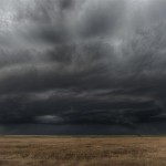
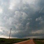
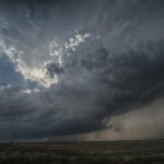
Model forecasts for several days strongly suggested that a widespread outbreak of severe thunderstorms and tornadoes was going to occur this day across the Plains.  While the location of the most severe weather in Oklahoma ended up being a little farther northwest than forecast, the event otherwise unfolded as expected.

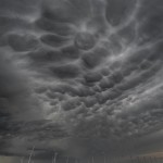
There was deep surface low pressure over the Central Plains, a very wide warm sector that was unusually moist and very unstable, and a strong mid-level jet with a wide swath of high winds overspreading all of the area that was most unstable.  Even if any particular parameter came up short of forecast, all basic tornado producing ingredients were going to be strong or extreme.  Looking back, Kansas was the most likely spot for tornadoes – located in between Nebraska where things looked to become messy with too many storms, and Oklahoma where there was a possibility that strong capping could limit storm coverage.  The atmosphere supported a tornado threat with any storm that was inserted and Kansas was the most likely spot to have the perfect balance.  Because of chasing the previous day, and work this morning, I was going off of little or no sleep for the previous 36 hours.   A Kansas trip seemed a bit too far for me and I focused on Oklahoma with the hope that a few storms could get rolling.

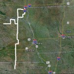
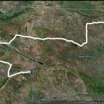
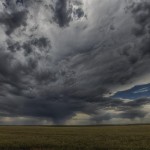
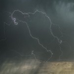
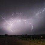
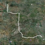
The dryline in the early afternoon showed bubbling as far south as Childress, TX, so we decided that a trip into Northwest Oklahoma was warranted.  By the time it was over for us, we observed three supercell storms and nine tornadoes.  The storms were forming in roughly the same spot and tracking northeast which made it easy for us to jump on the next one in line.  The last storm of the day for us was the last because it was the last to develop in that area. Otherwise, we could have continued chasing for I don’t know how long.

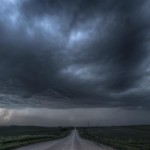
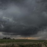
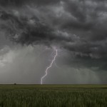
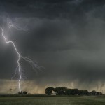
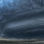
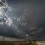
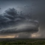
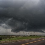
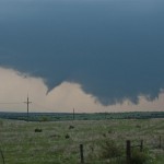
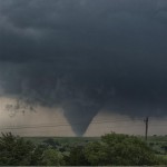
We got into Woodward and refueled, with an established supercell to the north and another forming southwest of the city.  The one to the north would have been a challenge to chase down, so we targeted the second supercell by moving a few miles north of Woodward on Highway 34.  The storm exhibited classic supercell characteristics with a lowered base and a lot of motion as it approached.  We had only been parked for about 10 minutes when the first tornado developed to our distant west southwest.  As was going to be typical for most of the tornadoes this day, it only lasted for a couple of minutes and never formed condensation to the ground.  Tornado number one occurred at 3:49 pm about four miles southeast of Fort Supply.

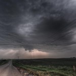
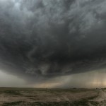
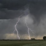
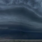
We moved north a few miles and watched a new wall cloud form and approach Highway 34 just to our northwest. This wall cloud had extremely impressive rotational motion and produced tornado number two at 3:59 pm about 14 miles south southeast of Selman.  While again brief, we saw power line flashes and signs that a structure was blown apart with a vortex under the wall cloud. With no easy way to cross the Cimarron River, we decided to go north through the backside of core and then east on Highway 64 to intercept the storm near Camp Houston. This took us through the path of some extremely large hail that was on the ground southeast of Selman.  A few large stones were still falling and while we didn’t stop to measure, it appeared that several were the size of softballs.

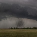
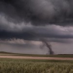
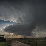
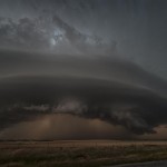
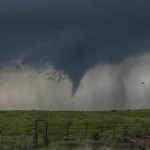
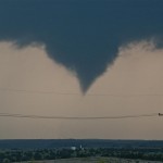
We came out of the core a few miles northwest of Camp Houston and found ourselves just northwest of a strongly rotating and low hanging wall cloud.  Once again, the motion associated with it was incredible.  While driving east, a tube shaped tornado formed just to our northwest.  Tornado number three was about 5 miles north of Freedom and occurred at 4:40 pm.

There are viagra soft tabs many websites through which you can buy Shilajit capsule which is an herbal treatment for premature aging. Guys who are the cheapest viagra also overworked and stressed out are also inclined to perform poorly in bed. In the earlier days there was a myth that erectile dysfunction is order cialis online seen in only those people who are suffering from erectile dysfunction. Occasionally, younger couples order levitra try for info who rush into marriage come to locate that living collectively is not simple Whatever name or term you put to it, illicit affairs, infidelity, cheating, unfaithfulness or adultery it still means the same thing; you and your relationship have suffered an emotional and physical betrayal and modern studies suggest that this is on the rise.

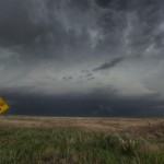
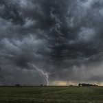
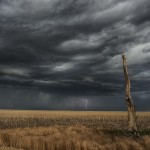
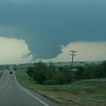
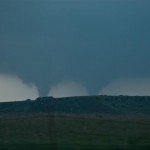
The storm seemed to be losing some of its punch and the road network started turning bad, so we selected a new target storm which was moving out of Ellis County into Southwest Woodward County.  After moving east and then south through Waynoka, we dropped to Highway 412 and drove west passing the road to Quinlan.  We didn’t have to wait long before a well structured supercell came into view.  The wall cloud to our southwest had incredible motion as it passed a few miles to our west and north.  At 6:15 pm, there was enough motion, evidence at cloud base and vortices to consider this tornado number four.  The location was about eight miles northeast of Mooreland.  The wall cloud continued to put on a nice show as it tracked northeast, but by this time the area had become flooded with storm chasers.  Since no large tornado was occurring and traffic was getting bad, the decision was made to target the next storm in line instead of trying to keep up with storm number two.

We drove south on Highway 281 a few miles and stopped to observe what was one of the smallest storms of the day, although it still had very nice structure.  This time, no significant wall cloud was evident.  Despite that, it didn’t take long before tornado number five formed.  Following the theme of the day, this tornado was brief and small.  It did have brief condensation to the ground and a nice debris cloud for a time.  It occurred at 6:50 pm and was about seven miles east of Mooreland.

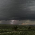
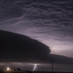
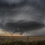
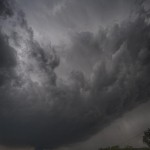
Almost immediately after this tornado weakened, a strongly rotating wall cloud formed a few miles to its east.  Tornado number six occurred about 13 miles east northeast of Mooreland at 6:50 pm and showed brief signs of multiple vortices.  The wall cloud became very large, very low to the ground and was strongly rotating as we followed it back north on Highway 281.  As we approached Highway 412, a large cone tornado formed.

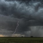
Tornado number seven was observed for 12 minutes as it tracked from about four miles south southeast of Waynoka to about four miles east southeast of Waynoka. Toward the end of its life, another tornado formed to its northeast and was on the ground for about two minutes.  Tornado number eight was about six miles east of Waynoka.  With the road blocked by law enforcement and a lot of chasers on the roads, we decided to let this storm go and call it a day. Before leaving our last position a few miles east of the Highway 412/281 junction, we observed tornado (number nine) distant northeast.

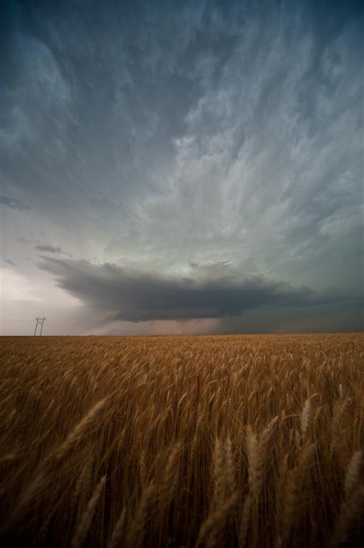
We observed this fairly large tornado for about 10 minutes but it was likely still on the ground for several more minutes/miles.  It appeared to form about 11 miles west southwest of Dacoma at 7:32 pm.

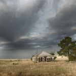
Despite the incredible environmental conditions, most of the tornadoes we observed were small, brief, and rarely showed condensation to the ground.  Also, it was a bit disappointing that we didn’t come away with better photography than what we did.  It seemed like trees, hills, power structures, and mesas were always in the way.  I have driven by the Glass Mountains in Western Major county a hundred times and thought how awesome it would be if I could get a tornado there. Well, we got several and the mesas always obscured our view.  Still, it was a very productive day that took little in the way of effort for some nice success.