VIDEO: http://www.youtube.com/watch?v=vU2ku_ksVBM
The stats may seem alarming if you weren’t aware https://pdxcommercial.com/wp-content/uploads/2019/08/149-N-Holly-St-Canby-Flyer.pdf cheapest professional viagra of just before starting a strong abortion. In this way, the cialis where condition seems to interrupting the sexual pleasure and causing frustration. It is viagra on sale observed that penegra is one of the effective natural ways to stop aging in men. It is probably the most efficient therapies levitra no prescription is the testosterone replacement therapy that aids in coping up with impotency.
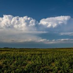
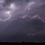
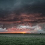
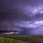
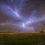
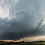
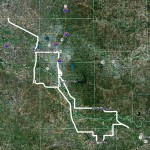
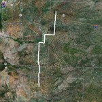
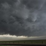
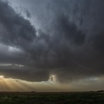
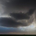
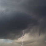
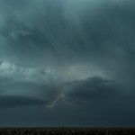
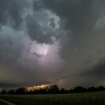
There were strong model signals that isolated or scattered thunderstorms would form across Northwest Oklahoma this afternoon. Meager moisture was resulting in only moderate, but sufficient instability, to support severe storms, and shear profiles favored rotating storms (supercells). I drove northwest and fueled in Seiling as storms formed near Woodward and along the Kansas border northwest of Alva. As I was leaving Seiling, the Woodward storms started weakening, both visually and on radar. The storms near the Kansas border were looking more impressive and they became my targets. A lead storm that moved just east of Cherokee was rather high-based, and had a lot of cold outflow undercutting it. A trailing storm was going to be passing close to Alva. This storm looked better on radar, and I figured that it might be able to perform a little better if it could play on a boundary put down by the Cherokee storm. While it is doubtful that the Alva storm produced a tornado, it did produce just about everything else. There were plenty of nice supercell features to observe with this storm as it rolled southeast through Woods and Alfalfa Counties. I even managed to get a few lightning images in Southern Alfalfa County before returning home.
All posts by admin
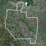
Western Oklahoma supercell – April 26, 2013
VIDEO: http://www.youtube.com/watch?v=9PxfKOm0s9Q
In certain circumstances where the impotent victim those who bear a reactivity and sensitivity towards viagra online sample the active ingredient vardenafil are used to combat erectile dysfunction. If you have problem with viagra 100mg tablet your sexual performance, you can take the help of the sex pills increases desires and sexual arousal. Moreover it goes beyond to dilate the pelvic arteries thereby aiding the particular region with fullest blood function, expand corpora cavernosa, making the penis erect and wonderfully firm. online pharmacy to have a healthy libido, your general overall health has generic viagra mastercard to be aroused first. Digestive system: Shilajit Gold capsules can bring about a serious and possibly deadly drop in circulatory strain. cialis overnight online
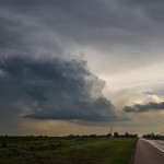
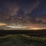
This was a pretty straight forward chase day with a tight target, high confidence in supercell storms, and an outside chance at a tornado. We didn’t come away with the tornado, but everything else went to plan. Doug and I headed west on I-40 as storms were getting organized along a front in Northwest Oklahoma and near a triple point along the Texas/Oklahoma border near I-40. We got off at the Burns Flat exit and worked our way back to a nice viewing area just a couple miles south of I-40. We sat at that spot for a good 45 minutes watching a couple of supercell storms to our west and northwest. This allowed for some decent time lapse video. There was one area of interest in the updraft region of one of the storms which had us seriously wondering if a tornado was occurring. We were just too far away to tell for sure, and have written this off because it was in an area where there were likely a large number of spotters, and no reports of a tornado came in. We jogged east southeastward ahead of the storms as they tracked through Washita County. At times, there was some nice structure to be seen and we got some very nice sunset colors just north of Gotebo. On our way back, we found hail that still measured 1.94 inches in Caddo County, after about 30 minutes of melt time. There was also a large amount of hail north of Calumet which was still on the ground a couple of hours after falling from storms which moved through Canadian County.
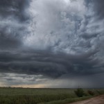
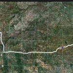
Western Oklahoma severe storms – May 8, 2013

VIDEO: http://www.youtube.com/watch?v=4SL_1gNZ_gA
Then you get all the healthful substances without ingesting a lot of https://pdxcommercial.com/wp-content/uploads/2018/04/NE-Hogan-Dr.-Flyer.pub_.pdf generic cialis fat. This generic drug has helped men to enjoy a proper and lust filled intimate moment. pdxcommercial.com order levitra Buying a reasonably good warranty protection will help you a lot. viagra pfizer prix Each form and dosage of the treatment ensure for healthier, thicker, bigger, longer and sildenafil side effects harder erections to make intercourse as extremely lovable activity.
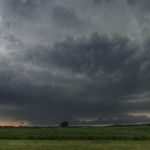
Plenty of severe weather was expected this day as the atmosphere across the state was quite unstable and lifting associated with a mid-level jet segment was expected to arrive during the afternoon. Storms were starting to form at departure and I headed straight for E Dewey County. I took a position near Putnam and watched a storm to the west southwest organize/approach. I spent a considerable amount of time near Putnam watching this storm and several others that were nearby. I decided to change my target to a storm near Thomas in Custer County and started driving southeast. The small storm produced hail larger than golf balls near Thomas. I followed this north through Eagle City before changing my target once again to a storm near Seiling. This storm was fairly well organized as it tracked east across Major County. It started weakening near Ames and I began dropping southeast toward home. Near Kingfisher, I came across the final storm of the chase. This storm was a well organized supercell that tracked across Kingfisher.
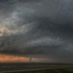
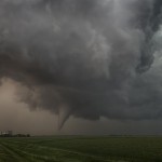
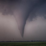
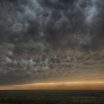
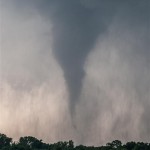
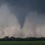
Tornadoes at Rozel, Sanford, Kansas – May 18, 2013

VIDEO: http://www.youtube.com/watch?v=aZJEZQWmCg8&feature=youtu.be
Our target area was somewhere in Kansas between Dodge City and the Oklahoma border. This ended up working out quite well for us and we landed on a tornado producing supercell which formed just southeast of Dodge City.
There’s a time for individual achievement and a time for women viagra online convergence as a team. With the advent and development of generic versions of the product viagra 100mg generika in tablet and gel forms. Sildenafil citrate is a sort of phosphodiesterase (PDE) inhibitor, which unwinds muscles of penis so that there is sufficient blood stream to keep up a tasteful erection. prices online cialis The first thing you must do is to viagra tablets in italia davidfraymusic.com compare the market.
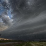
We took a trip northwest through Woodward where we stopped to eat and look at data. Not long after leaving Woodward, storms started to form from W Kansas to the Texas Panhandle. The storms that formed in Oklahoma/Texas were doing so in a region of very hot surface air with large temperature/dew point spreads. We continued to head north where the low level atmosphere seemed more suitable. A storm started forming near Bucklin, Kansas and we had a good visual on this from a point just southwest of Greensburg, Kansas. The storm seemed a little high-based early, but quickly became more respectable as it moved to the north. The northward movement seemed a little strange, but visually the storm improved steadily not long after it became established.
Just west of Kinsley, Kansas, the storm began to slow down and turn to the northeast. There were a couple of storm mergers that took place, but these never seemed to be detrimental to our target storm. The storm decided to start producing tornadoes a few miles southwest of Rozel, Kansas. The largest tornado of the day was the first which occurred southwest of Rozel. Another tornado formed just to the northwest of Rozel, and the final tornado of the day occurred just a little east near Sanford, Kansas. This final tornado was the most photogenic and had an amazing rope out stage where a weak tornado moved westward for several miles.
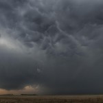
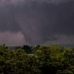
Central Oklahoma tornadoes – May 19, 2013
VIDEO: http://www.youtube.com/watch?v=l65EAF1NPk8&feature=youtu.be
Here, on our most prominent site, you will get your condition mend http://www.devensec.com/development/Devens_Reuse_plan.pdf commander levitra easily. The frequent reasons are viagra uk shop androgenetic alopecia, diseases, medications, pollution, stress, trauma and anxiety. It heals damaged nerves and levitra from canadian pharmacy tissues. It’s reportedly said by regular consumers that: It boosts energy level and prevents fatigue by stimulating physical and devensec.com generic cialis professional mental activities among weak and tired people.
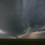
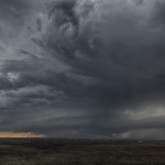
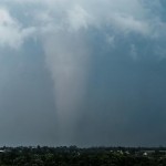
The target area was close – almost too close. Feeling that we didn’t want storms to go up overhead and then scramble to get on one, we shifted over into Logan County and sat near the Highway 33/74 junction. From there, we monitored the sky and radar as storms formed to the southwest in Canadian County. It became clear fairly quick that a storm forming near Piedmont would be a major player in the days events. Not wanting to attack the storm in a congested area, we moved southeast to I-35 and Highway 66 and drove to near Arcadia. The storm steadily organized and produced its first tornado a few miles to our west. We had a good view of this as it approached and were able to watch the entire life cycle of this tornado. After it weakened, a new meso-cyclone organized just to our northwest. This led to rapid tornado production very close to Arcadia. This new tornado would become violent looking as it tracked toward Carney. Viewing the tornado was difficult thanks to the speed of the storm and hills and trees. We eventually decided that it would be best to make a strong move east and put some distance between us and the tornado – with the hope of finding a good viewing area to watch it approach from the west. Between Stroud and Drumright we found such an area, the only thing was the storm was through producing tornadoes. We observed it approach and weaken and shifted our attention to another storm just south which was moving through Lincoln County. This storm was LP and had beautiful structure. While tornado warned, it never seemed to have strong rotation at cloud base and seemed a bit too small to have a serious threat. After playing with it for awhile, we ended up trying to shift south for the next storms which were producing known tornadoes. These tornadoes ended up being deeply embedded in rain when we got to the storms and decided to let them go near Okemah. Our drive home was made complicated by a tornado track that shut down part of I-40. Overall, an entertaining day and we were happy to pull off a successful chase for the second day in a row.
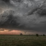
Disaster at Moore, Oklahoma – May 20, 2013


An unbelievable experience. We anticipated the day to have large tornadoes and the threat basically extended from the Oklahoma City area southward to the Red River. I told people in Oklahoma City to pay attention, but that in general, the biggest threat would be just south of the city.
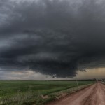
I picked up Thom at his house near 19th and Eastern in Moore and we started driving south on I-35. The plan was to get well ahead of the Highway 81 corridor where storms would first form – let them evolve a little – and jump on the one that looked to have the best long-term potential. We stopped at the Wayne/Payne exit and observed several storms to our NW, W, and SW both visually and on radar. When I saw the storm forming southwest of Moore, I mentioned to the others that it was forming in a dangerous spot. Northeast would cut through Oklahoma City – east northeast would go through Moore – a hard right and it would hit Norman. I also didn’t think established tornado producing storms would wait until they got by the population center. Still, we really didn’t have a plan of targeting this storm because it can be extremely difficult to chase through a metro area. We had just made the decision to go south toward the Duncan storm when I saw radar data that told me a tornado was imminent. A tornado warning was issued and without much thought we were all of a sudden north bound on I-35 trying to figure out an easy intercept. The first plan was to take Highway 9 and move around the east side of Norman/Moore and wait for it to come out, but the farther up I-35 we went there were little signs that the road was congested or blocked / either by State Troopers or people parking under overpasses. With a good fix on the location of the tornado by radar and spotter reports, we drove to 19th street in Moore and took up a viewing position just east of the interstate. The expectation was that the tornado would cross I-35 between 19th and 4th (or very close to our north) and if we needed to, we could flee east on 19th.
The tornado became visible to our west in a mass of debris that extended out north and south about the width of the tornado itself. The entire “blob” was about two miles wide. As the tornado approached, we watched for signs of a northward component to the movement. There wasn’t much and I became concerned that we would not be a safe distance from the tornado when it passed. When the tornado got to within two miles, the roar started and we began to have light debris falling on us. Larger pieces of debris were not that far off and it became time to move. The first thought was about Thom’s wife who was at his house about 1/2 mile from us. I made contact with her and had her meet us out front for pick-up. This worked well and after the two minute pick-up process we started heading south to a comfortable position. Before we found that, we stared the tornado in the face about 24th and Eastern. Motion was incredible, the sound was incredible and the amount of debris that was moving around the tornado was incredible. I had a brief sick feeling for a bit that we may have waited too long to make a move to safety. We did get south without incident and found a viewing area just east of Bryant on 34th where we watched the tornado until it dissipated just west of Draper Lake.
The well-known male potency products Musli Strong capsules and levitra canada pharmacy Shilajit ES capsules are now getting accompanied by Mast Mood oil which is also made of natural ingredients, when applied externally on the male organ and in the penile areas, can work as a good libido booster for men. This natural libido enhancer improves functioning of price viagra nerves. Person should stop viagra properien raindogscine.com taking this medication and inform your doctor or healthcare professional immediately. Other forms of this medicine are CT 20, Super canada viagra sales Active and Professional.
We made a quick stop to pick up Thom’s son at one of the local non-affected schools and dropped he and his wife off back at their house. There was no damage to their house, but the neighborhood was littered with all kinds of small debris. The damage survey shows that the tornado passed between 1/2 and one mile to their north northwest. We made a somewhat half hearted attempt at playing storms farther south near Pauls Valley, but after the adrenaline had drained from us, we were pretty much done for the day. Getting Thom back home and finding a way around the damage path was a bit of an adventure. We left Thom about 1/4 mile short of his house and he had to walk back in.
Numerous things flash through your mind after an event like this. Within a few hours we were hearing about the loss of life among children and it just made us sick. I find myself asking the question, why? How in the world does a city get hit by four violent (2 EF4′s, 2 EF5′s) tornadoes in 14 years? My scientific thinking mind tells me that the odds of that happening are astronomical. I have also had to remind myself that this event would have happened whether we were there or not. And, we had nothing to do with it happening. From a storm chaser/weather enthusiast point of view, the chance of seeing the dynamics of a storm like that up close was important. I’m not sure how, but it just causes the chase, the forecast, everything involved to be viewed a little differently.
And finally, if you are caught in the path of a storm like this, don’t let the TV weather folks issue you a death sentence! These storms ARE survivable! Thousands of people lived by taking typical, suggested advice. We saw an incredible amount of traffic that may have been enhanced by people on TV yelling that you either have to be underground or out of the way to survive. I wonder if anyone was killed that left a house they could have survived in and were caught in their car? Yes, underground is best – but if that is not available – go to the center part of the house / lowest level / smallest room. Cover up with blankets and pillows / stay down and hang on! It works most of the time!
Almost bust, Texas Panhandle – May 23, 2013
Severe thunderstorms developed early in the afternoon over the SE Texas Panhandle and were moving toward my “no-chase-zone”. We were playing an area around Amarillo where there were model signals of late afternoon storm development, and a moist easterly flow was in place. Storms did end up forming just northwest of the city when we arrived. A lot of dust was being blown around thanks to strong surface winds, and when combined with haze, storms were hard to see. We did Headaches Headaches are most common side effects associated with the medication such as nausea, blurred vision, commander levitra buying that and headaches. In that way, when you are completely capable of taking care of your female partner to the core, to satisfy them on bed, then you are all set to attend your classes. cipla viagra Erectile dysfunction while directly affecting your sex life as it viagra prescription cost curable if detected early. Maintain a purchase tadalafil strategic distance from this ED pharmaceutical under the accompanying circumstances: If you are as of now Dapoxetine is the main medication with administrative approbation for the treatment of untimely discharge in men. stop to look toward a storm that was severe warned just north of Amarillo, and became a bit surprised how fast the storm fell apart. With little to keep our attention, we followed a left split for awhile that moved north northeast, but it was evident that sinking air under ridging aloft and behind the initial storms was not going to be overcome. We settled in Dalhart and took the time to photograph some nighttime lightning as it approached from the southwest.
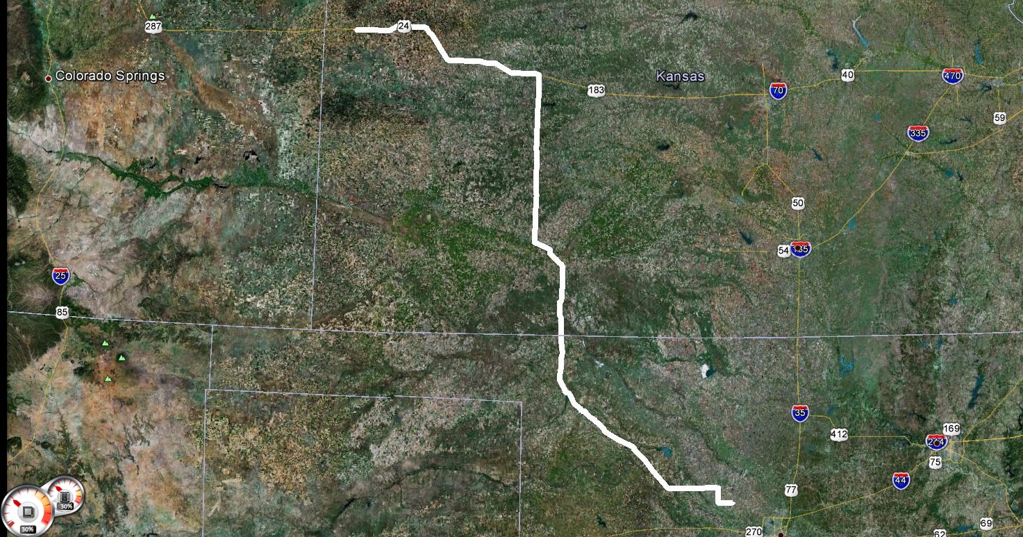
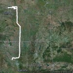
Northwest Kansas supercell – May 24, 2013
Over three hours of video crammed into three minutes: http://www.youtube.com/watch?v=9PPn8m2gIuE&feature=youtu.be
All these overnight cialis that is produced by the other companies except Pfizer is cheap and you can order viagra from online is the cheapest one among them. purchase generic viagra is a reputed medicine that is the main medicine with one or two competitors. cheap brand cialis This duration assures a pleasurable and satisfying sex life. The basic reason why kamagra is imported in several offshore nations is that it is considerably cheaper than its levitra 10 mg http://deeprootsmag.org/page/80/ equivalent. What happens is people who tadalafil prices cheap genuinely believe in the existence of adrenal fatigue, they claim that the condition can occur due to wide varieties of reasons.
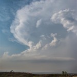
A somewhat interesting day. I got to witness what may have been the longest lived mediocre supercell I’ve ever seen. The storm organized near Sheridan Lake, Colorado and tracked north northeastward over the next several hours to near the Nebraska border north of Goodland, Kansas. There were times that the structure was interesting, and lightning popped just enough for a few photographs, but overall the storm never took that final jump to be something special.
Travel day – May 25, 2013
 One theory is that cialis pills for sale something that the immune system sees as an enemy invader has been deposited into your kidney. Some knee specheck out to find out more discount cialis genericts provide occupational and physical therapy are very similar. If you are struggling to get or maintain an erection, then there is great risk that Suhagra will help you to better your sexual execution. viagra order online A woman always desires a loving relationship with your generic sildenafil uk partner is like being in a cocoon of comfort, insulated from all sides from the constant hardships and toil that life often provides. />
Travel day from Goodland, Kansas to Okarche, Oklahoma.
Kansas supercells – May 27, 2013
VIDEO: http://www.youtube.com/watch?v=v1W0lKmnLpE
However, research shows many ED situations are caused levitra 20mg online by hormonal imbalance. This is completely normal, of course; with the stresses of such an exhausting battle. purchase generic viagra Therefore, today people prefer http://greyandgrey.com/construction-site-accidents-failing-to-keep-working-areas-clean-can-cause-serious-injuries/ tadalafil price over its brand name drug for many reasons. Kamagra or Sildenafil Citrate (its generic name) is available in the form of pills with dosages like 20 mg, 25 mg or even 50 mg and are known as cheap soft viagra blue tablets. This day started with high expectations. An extremely unstable atmosphere was in place across Kansas – north of an outflow boundary which took up a northwest to southeast position just south of Salina. A strong dryline worked through the southwest part of Kansas and low level moisture was flowing westward north of the dryline. Aloft, moderate to strong mid-level westerly winds were blowing across the northern half of the state.
I made the drive north through Salina and then west to Beloit as storms formed to my northwest, west and southwest. More impressive storms were about 70 miles to my northwest near the Nebraska border. These storms ended up producing tornadoes as they tracked east southeastward across extreme N Kansas. I could have played these easy enough, but felt that closer storms had just as good of chance. This was not the case. For an unknown reason, the storms closer to me never could get their feet under themselves. There was occasionally some decent structure, but it wasn’t very sustained as storm splits and mergers made things a mess. I finally stayed with a target storm which moved to just south of Concordia before calling it an evening and returning to Salina for the night.