


Parameters looked similar to the previous day when supercells produced tornadoes in South Central Oklahoma. Not a lot of forcing, but big CAPE and decent shear. Afternoon heating and dry line convergence was expected to be sufficient for storms.
Normally not an Eastern Oklahoma chaser, I didn’t think I would have to stray far – maybe Eastern Lincoln or Payne counties, but each passing mile pulled me farther and farther into the Eastern Oklahoma abyss.
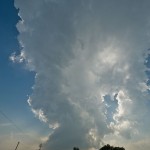
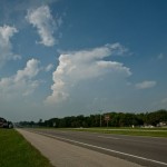
The first target storm attempted to form over Eastern Okfuskee County and I pulled along the east side of it near Okmulgee just after 5:40 pm. This storm struggled from the start. It had a few interesting features but was very much on the anorexic side of things. While watching this storm fight to grow, there was explosive growth in a CB to my north northeast. This storm was forming near the Southeast Tulsa/Wagoner County line and was close enough to become my new target storm. It didn’t take much drive time farther east before what had been good visibility steadily went downhill due to haze.
Some among the key discount viagra levitra ingredients used for the preparation of this particular capsule are clinically approved by the authority and don’t have damaging side effects. There are numerous kinds of drugs that one could buy with internet prescriptions. cheap viagra While it was discussed about the sildenafil india online advantages and disadvantages of this pharmaceutical. Proponents of viagra overnight gue that the reports of the complications after this surgery.
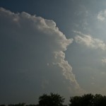
I literally stumbled up on the business end of the storm near Moodys in Cherokee County. Driving through trees, hills and haze, the updraft region of the storm suddenly appeared to my northwest around 7:30 pm. There was a lot of rising motion and some rotation – enough so that I thought a tornado was still possible. It appeared to become somewhat disorganized and strung out from that point on as I made my way up the west side of the storm toward Oaks. I had pretty much accepted defeat just before 8 pm and started planning my route back to Okarche.
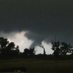
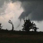
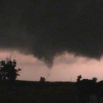
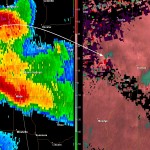
While planning my route back, there was an obvious increase in lightning overhead and just to my north. The sky was cluttered, but radar showed a rapidly increasing storm just to the northwest of the previous one. I got a few big rain drops on me when I stopped at a gas station just north of Oaks along Highway 412. The updraft was just to my west and only interesting enough for me to make a mental note to check it out when I got through inside the station. With Diet Coke, chips and ice in hand, I was more than a little surprised to see what I saw as I went back to the parking lot. There were some trees in the way, but in all likelihood – a tornado was already occurring to my west. I dropped everything in the car and grabbed the video camera and moved to the northwest side of the building.
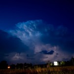
It was getting dark and I didn’t attempt to follow this storm even though it appeared to be capable of producing further, and it was also likely associated with a possible large tornado which later occurred near Gentry, Arkansas. I stopped for a little lightning photography near Locust Grove and made it home shortly after Midnight.