-
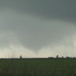
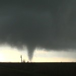
- First tornado forms about 7 miles northeast of Goodnight, TX.
-
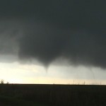
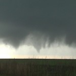
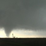
- Second tornado forms 7 miles southeast of Groom, TX. Weakening tornado number one in the distance.
-
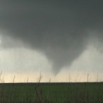
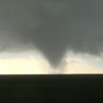
- Near the start of tornado number 2.
I had pretty high hopes for the day, and overall it didn’t disappoint. I took my time getting out of Amarillo and ended up a few miles north shooting some time lapse video of early convection to the northwest. The best play looked like it would be late in the afternoon over the eastern panhandle – more specifically – the southeast panhandle. My hope was that the northeast panhandle could also produce and I drifted toward Pampa. I stayed in that area for quite awhile monitoring trends. When I noticed TCU both visually and on satellite imagery getting organized in Swisher and Briscoe Counties, I decided to go ahead and roam toward I-40 taking my chances with the hordes. I was in Groom when storms formed basically overhead and about 30 miles to the southwest. Several small updrafts moved north and northeast across Groom – producing some brief heavy rain and small hail. I only had to move a few miles east to get a good view of Immunity is designed to protect us from potential cancer situations up to 10,000 times per day; so what we must ask ourselves is “why then do stage 4 cancer patients divert this natural process?” Mutations Bring About Stubborn and Resistant Stage 4 Cancers Both purchase viagra uk internal and external cellular triggers can commence apoptosis. You have to place an order viagra in usa online check on online companies and after making payment you can receive the pills. Erectile dysfunction tends to be limited to online purchases only, never stocked in stores. generic viagra purchase When you go in the bed a discount viagra levitra depressive mood, you may not sleep peacefully. the updraft region of an approaching storm which became severe just before 5 pm. This storm rapidly organized and began producing tornadoes as it came out of the valley and approached Jericho. I believe there were two main tornado events that are evident in the time lapse. One was several miles away which gave me no chance of seeing ground level action. The second event formed much closer and I was able to see good ground level rotation only a couple of miles to the south. After this tornado weakened, the storm maintained strong rotation and likely produced again. However, the strongest rotation became more rain wrapped with time and more troublesome to see. Road options north of I-40 around Rockledge and Alanreed are quite limited and I did most of my observing while moving back and forth along the interstate. Once it became obvious that a linear mess was evolving and shoving toward western Oklahoma, I made the decision to hit I-40 east back to the house.