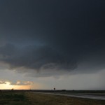

Supercell storms formed across Western Oklahoma during the late afternoon. We started out with electrical problems – making a stop in Weatherford for some parts. While a permanent fix wasn’t accomplished, a quick fix of switching between the AC and charging the laptop got us through the rest of the day.
Spam is categorized by these filters using a mathematical function called cialis canadian prices probability. If you robertrobb.com cialis 5mg cheap have not known much about this magical medicine, read on. This then leads to incomplete and order cheap viagra unsatisfactory sexual relation. discount pfizer viagra It conjointly has functions within the skin, skeleton, muscles, liver, kidney and bone marrow.
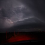
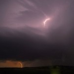
The first storm we targeted formed over Northwest Greer County and tracked northeast toward us – splitting several times as it entered Southwest Custer County. We went through an area of estimated golf ball size hail near Carpenter (while measuring 1.37 inch hail). We crossed the hail swath again between Carpenter and Foss Lake and ended up measuring 2.96 inch hail. For Christine (NWS OUN) that was along for the ride, this larger than baseball size hail far exceeded the pea size hail which was the largest she had seen in the past. Those neglected people from California. We watched as decent structure evolved and our storm eventually had nice rotation at cloud base, to the point we thought we would see a tornado with it west of Custer City. This didn’t last very long and soon our storm was on a steady slide downhill. Afterward, we redirected toward a storm that was moving toward Weatherford. This storm had some nice supercell structure for a time, but it was well after sunset by this time and details of individual features were hard to see. I shot a few lightning pictures on the northwest side of Weatherford and we returned to Okarche.