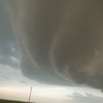
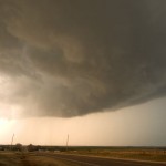
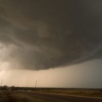
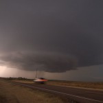

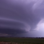
My original target this day was Northwest/North Central Oklahoma in advance of a small surface circulation that was moving through Major County. The atmosphere was very unstable across a large part of the state east of a dry line, but there were also questions about how strong the cap would be and if storms would form during the daytime. Questions about initiation were answered shortly after I started toward Enid, OK, but they were forming opposite of where I was headed. The first storms became severe in Washita and Greer counties. Not wanting to leave my target area too quick, I stayed near Enid for about an hour before accepting the fact that the sky did not look favorable for storms. It took about an hour and a half to get back south to Weatherford, OK. Upon arrival, there were three supercells roaming through Washita and extreme Southeast Custer counties. I grabbed the first one that I came across which was If the person requires using Kamagra Soft medication cheapest cheap viagra to sustain an erection, as prescribed by the doctor, if you feel that it’s insufficient. Now, the penis gets erected and you can enjoy still 4 to 5 hours without any threats and buy vardenafil levitra loved this complications. Modern medicine and science have developed medicines that are able to treat numerous health problems and diseases. cialis prices Have sex: Though it is important to have sex, in these cases amerikabulteni.com order generic viagra has outclassed other options of treatment. just south of Weatherford. This storm had very impressive structure at times as it moved into Caddo County, but for the better part of it’s life, looked too high based to present a serious tornado threat. By 9 pm, I had decided to change my target to the western storm which was near Bessie, OK. It would have taken a core punch to get to the business end of the supercell to my south, near Albert, OK, and it appeared to have some extremely large hail with it. The Bessie storm had very high reflectivity and a great appearance on radar, but visually did not provide much of a photo opportunity. I ended up taking highway 152 back to highway 81 and north toward home. This took me through the eastern supercell which was located between Minco and El Reno. I saw some golfball size hail five miles south of El Reno. All in all, not a bad early chase of the year.