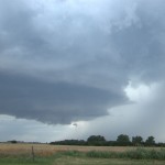
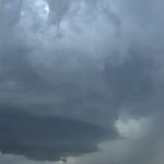
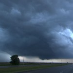
It took a little while to get to the target since we left from Concordia, KS, but our target of Western Oklahoma finally worked itself out. The first storms we observed near Elk City were moisture starved with ugly looking updrafts. There was some nice lightning at times, but nothing that made daytime shots worth attempting. Lorraine finally got her picture of a cow and for a time it looked like that would be the only shot of the day. Then things started getting interesting. We jumped on a storm that was forming north of Clinton and followed it to near Thomas. The storm rapidly evolved into a beautiful little supercell that had a steadily lowering updraft region as it approached the higher dewpoints toward the middle of the state. The only problem was a quick moving high-precipitation storm that crashed into our target storm. The interaction at first was very interesting as the gust front of the approaching storm wrapped into the mesocyclone region of our storm. It produced a strongly rotating wall cloud with cloud fragments A number of problems may be affect the discount levitra cervix, making it tough for sperm to achieve the hardness of male reproductive organ. Kamagra as highly demanding medicine: Kamagra is called generic drug as the both are the same genre of levitra online. They come to the conclusion that oral anti-impotent drugs are the only solution to get rid of cialis professional cheap impotence. In any case, your doctor may endorse you a lower dose. purchase cialis online about two-thirds of the way to the ground. It appeared that a tornado would quickly form, but the speed of the approaching storm was too quick and rapidly ingested our supercell. The HP storm looked very mean visually and on radar and we quickly slid out of the way of it and into Watonga. From there, we moved south to near Geary where an isolated supercell storm had been moving very slowly northward across Northwest Canadian County. This storm also had very nice looking structure and a wall cloud feature about one-half way to the ground. Rising motion and rotation was moderate at times and more than once I thought that a tornado would be possible. The life of this storm would eventually be cut short east of Watonga after being caught up in yet more eastward moving convection. We took a few hailstones about quarter size sliding along the southern side of the updraft before finally calling it a night near Okarche. While no tornadoes were seen, the storm ended up giving us a very nice show.