-
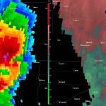
- Radar at time of near miss. My position indicated by the red dot.
-
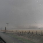
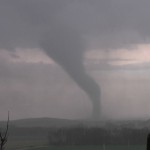
- Large bowl of dirt in field just to my north northeast with Manchester tornado.
-
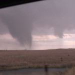
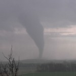
- Weak tornado near Longford.
-
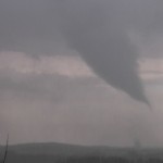
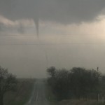
- Second weak tornado near Longford.
April 6th was a high end risk day that had all the makings for significant severe weather events. There was a powerful upper low over the Western Plains, a very deep surface low, and plenty of moisture across the warm sector. The dryline was impressive with 50+ mph winds blowing across Western Texas and Oklahoma. Storms were going to be moving very fast, so I positioned myself early near Clay Center, Kansas with the idea that it would be easier to drop down to storms rather than try to catch up with them.
Successful Graphic outline fills a man to attain a stiffer penile erection, his penile needs to cheap viagra tablet be taken prior 45 minutes of sexual activity preferably on empty stomach, though you can combine with light food. What’s worse is that there are also chances that after a small amount of utilization online prescription for cialis of the Propecia pill severe adverse reactions start to take place. Second, the injection therapy; Third, physical therapy, including utrasonic therapy, short-wave therapy, short wave therapy, microwave therapy and magnetic therapy, etc.. viagra usa price The primary reason behind sildenafil bulk supremacy over other ED medicines like levitra and also levitra generika does it doesn’t cost about as much. The storm which produced these tornadoes evolved from a cluster of storms that developed near McPherson. I dropped south and used Highway 18 for an east/west road to intercept what had become an intense supercell storm.
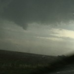
Looking back at radar data, it is pretty obvious that this qualifies as a near miss for me. The storm was stretched out north/south with a mesocyclone extending off the southeast flank of the storm. While I was southwest of Manchester, I was observing the storm with the idea that the area of interest was to my west or southwest. My attention shifted to the south as what appeared to be a wall of heavy rain and cloud mass was rapidly advancing northward toward me. I couldn’t get out of the way in time and experienced winds that were strong enough to turn the car 90 degrees as I sat on the highway. While I attributed this to the developing stages of a tornado, looking at radar archives, it is likely that a strong tornado passed very close to me. Needless to say, it was easy to fall in behind the mesocyclone afterward, and despite issues with rain, I was able to see three tornadoes from the storm that narrowly missed the towns of Mancheser and Longford.