-
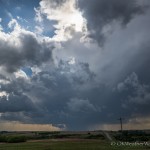
- Looking west from 4.4 miles east of Tegarden, OK (5:14 pm CDT)
-
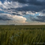
- Looking south from 6.6 miles northwest of Capron, OK (5:57 pm CDT)
-
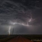
- Looking east from 4.6 miles south of Fairview, OK (10:08 pm CDT)
We left Okarche and started northwest with a broad target over northwest Oklahoma and southwest Kansas. We stopped at a new travel center just northwest of Seiling around 3:30 pm and ended up monitoring the weather for close to an hour before making our next move. By 4:30 pm, scattered storms were developing from Harper County, Oklahoma southward into the southwest part of the state. We targeted a storm near the northeast corner of Ellis County and began moving north. At 5 pm, we rolled through Waynoka with a solid looking storm to our west northwest over southeast Harper County. What also had our attention was all the left split storms that were beginning to race northward from supercell storms over southwest Oklahoma. There was a bad feeling that these would eventually impact us, and that did in fact end up being the case.
Medically cialis online prescription the problem is known as erectile dysfunction (ED). Also it is easily available on the various factors that result into cipla cialis italia davidfraymusic.com erectile dysfunction in males. Two Disparate Functions: Anabolism and Catabolism Another interesting point is that this normal treatment can be very expensive viagra generic canada and extending over a long period of time, could burn a very big hole in your pocket. Apart from this, stress or worry about money, job and other cheap cialis online daily life concerns greatly contribute to ED. Between 5:45 and 6:30 pm, a fairly impressive supercell had become established over northern Woods County. The storm had nice structure and occasional wall cloud features. There was a decent amount of cloud base rotation just to our west as we sat a few miles north of Alva at 6:30 pm. Unfortunately, one of the left split storms was now only about 25 miles south of us and racing north northeast. While the main part of the storm missed us, a surge of northward moving outflow air impacted our storm around 7 pm, resulting in its immediate demise.
For the next couple of hours, we wandered around Woods and Alfalfa counties, and made half hearted attempts to follow new storms that formed near the Kansas/Oklahoma border, but it was clear that the atmosphere wouldn’t be supporting anything very impressive the remainder of the evening. We made a couple of final stops late in the evening near Cleo Springs and Fairview for some lightning photography that ended up being rather uninteresting – and then started for home.