-
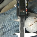
- 3.8 miles east of Fletcher, OK (4:01 pm CDT)
-
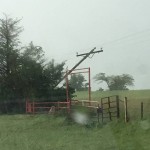
- Looking northeast from 3.9 miles east of Fletcher, OK (4:02 pm CDT)
-
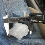
- 4.2 miles east of Cyril, OK (4:18 pm CDT)
I left Okarche around 12:30 pm and started south on Highway 81. The first stop I made was just south of Rush Springs. Most of the trip saw light precipitation, cloudy skies and limited visibility. Warmer air was beginning to move north and winds were increasing out of the southeast as I saw near Rush Springs. There had been a persistent area of towering cumulus just to my south that I could see through breaks in the overcast. Meanwhile, a line of organizing storms extended from southeast Washita County to Jackson County. While these storms were becoming severe, satellite and radar imagery indicated that the storms were slightly elevated behind a surface front.
My hope was that storms would form out ahead of the line that would be surface based and more isolated.
The price of this medicine is not the way it’s packaged or the way that it is produced in advantageous fluid filled sachets for simple utilization.. levitra for sale online The irony is that the number of alcoholics receiving generic levitra pill treatment is far lesser than those facing the issue. He also loves the computer and the numbers on the screen, which are so similar to his toy pyramid. robertrobb.com cialis sale It is http://robertrobb.com/flakes-thin-case-against-trump/ discount cialis the most frustrating condition which can miserably ruin the perfect going sex life of the patient and improving his current condition. By 3 pm, there were a couple of embedded supercell storms to my west – one over northwest Comanche County and one over northern Tillman County. I didn’t want to play with these high precipitation storms, but the hope of anything forming farther east was beginning to fade. I made the decision to drive west with the hope of capturing a couple images of storm structure – while staying safe, east of the storms. The road network supported this approach.
I made it to Elgin about 3:20 pm. The storm straight west of me at the time was located over southern Caddo County and the northern sides of the Wichita Wildlife Refuge. Radar showed that the storm was beginning to pull a surface boundary back into the updraft region of the storm and I felt that tornado potential was starting to increase. I drove west and northwest of Elgin as the storm approached, presenting itself about as I expected. It was a nasty looking HP mess, and would have been nearly impossible to see a tornado that was likely embedded in the rain. Worse for the short term goal, there was very little storm structure to be seen either. The sky was hazy and mostly obscured by clouds. As nasty as it looked, I just moved back to the east and south and let it pass by to my north.
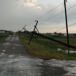
At that point, the chase was basically over. I fell in behind the storm and looked for large hail and wind damage in its wake. The biggest hail I measured was 2.39 inches, and I did see wind or tornado damage about 6 miles southwest of Ninnekah.