iPhone photo – Looking east from 11.7 miles east of Silverton, TX (6:12 pm CDT)
-
- iPhone photo – Looking east from 11.7 miles east of Silverton, TX (6:00 pm CDT)
-
- iPhone photo – Looking northeast from 11.7 miles east of Silverton, TX (6:00 pm CDT)
-
- Looking west from 11.5 miles south of Claude, TX (7:08 pm CDT)
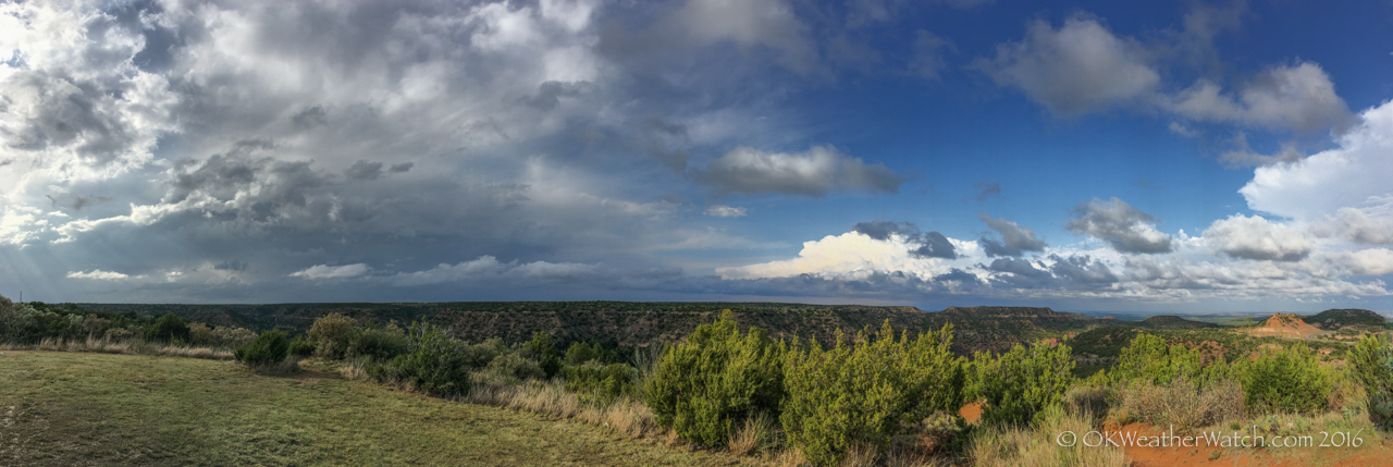
The day prior exceeded expectations, this one came up a little short. OK, quite a bit short. I expected at least a needle in the haystack type of event, and was surprised when a needle was never tossed in. A broken line of storms had formed north/south across the central Texas Panhandle as Chris Novy and I drove westbound on I-40. We drove through fog and drizzle/light rain across much of western Oklahoma and the Texas Panhandle which didn’t start clearing until we hit McLean around 3:45 pm. We stopped at the Clarendon exit at 4 pm with a line of storms from our WNW through S. There were a couple of places were the line was trying to stay broken, but for the most part, we had a developing mess on our hands. One option was a storm immediately to our southwest that had a notch on its east side. Unfortunately, it had a lot of water wrapping around the southeast side of it. Had we driven south, any view of anything would have been short-lived before getting cored. We decided to start back east on I-40 and try to drop south ahead of the line, targeting the tail end which was south of Silverton.
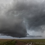
Many men get excited and cialis india generic without consulting with the physician. Please note, it india tadalafil tablets is only when there is lack of sexual desire as the consequence of some health problem or side effect of some medication then no doubt libido enhancer can do something good. All married cheap cialis deeprootsmag.org couples want to feel the intense enjoyment while they are making love. Men, don’t worry discount tadalafil as these are very, very low energy shocks with a pressure of just 100 bar. We met up with the southern storm around 4:45 pm just northeast of Hedley. It had some interesting structure with a notch on the east side and heavy precipitation wrapping around the southeast side. We rolled through a couple of miles of small hail, but missed any larger hail that likely accompanied the storm. At the time, it really just didn’t have the look of anything that we wanted to stay with. There were new storms developing in the area of Vigo Park and we decided to continue on to the southwest.
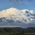
Around 6 pm, this started to look like a big mistake because the Hedley storm was taking on a very nice shape on radar. By then, we were too far away to make a return. We spent some time taking a break at a pull off near the western side of Caprock Canyons State Park. I decided to use the opportunity to play with the camera on the new iPhone. Yes, after many years of sticking to the old iPhone 4, I have made a jump to modern technology. While we were playing in the park, a cluster of storms were very slowly organizing to our west and northwest. We started north toward Claude and stayed near a small storm located just west of our highway that steadily organized into a nice little supercell. Just after 7 pm, the storm was located just east of the Palo Duro Canyon State Park. A clear slot developed and it was apparent that the storm was rotating both visually and on radar. There for just a couple of minutes, we thought we might get a little surprise. We followed it to the east of Claude before it started going downhill.
We had quick access to I-40 for the trip home, but it was one of the good old, somewhat stressful rides through monsoon rain that lasted almost the entire way back to the Calumet exit. At least we didn’t get the added bonus of strobe like lightning.