-
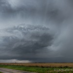
- Looking west northwest from 2.0 miles east northeast of Odell, TX (5:18 pm CDT)
-
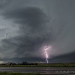
- Looking southwest from 1.2 miles southeast of Elmer, OK (5:30 pm CDT)
-
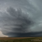
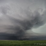
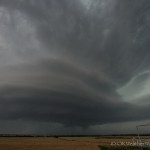
- Looking southwest from 7.5 miles west of Tipton, OK (5:40 pm CDT)
-
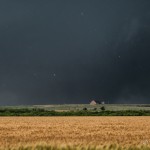
- Looking southwest from 7.5 miles west of Tipton, OK (5:45 pm CDT)
-
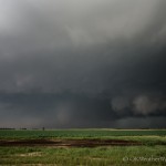
- Looking west southwest from 7.5 miles west of Tipton, OK (5:55 pm CDT)
-
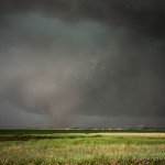
- Looking west from 1.5 miles west of Tipton, OK (5:59 pm CDT)
-

- Looking west from 1.5 miles west of Tipton, OK (6:01 pm CDT)
-
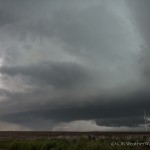
- Looking west northwest from 1.5 miles west of Tipton, OK (6:03 pm CDT)
-
- Looking southwest from 4.7 miles west southwest of Grandfield, OK (7:06 pm CDT)
-
- Looking west northwest from 3.0 miles north northwest of Pleasant Valley, TX (7:53 pm CDT)
Thunderstorm development began over the Texas Panhandle and Texas South Plains before I left. Morning storms had stabilized the environment across northwest Oklahoma. What was a rather large target area the night before, became fairly concentrated over southwest Oklahoma. I had made it to near Clinton when the first tornado warnings were issued in the Texas Panhandle. I was a long way off, but the first warned storm seemed like a good initial target. When I reached Elk City just before 3 pm, things had become messy around the storms near Shamrock, Texas and a county or so to the southwest of there. I didn’t even take the time to look at those storms and turned south on Highway 30. I told Doug Speheger that if nothing else, I just needed to get however far enough south that it took for storms to remain discrete.
I stopped around 4:15 pm in the far southwest corner of the state and observed a small supercell that was near Dodson, Texas. It didn’t hold my interest very long and I considered waiting for another storm that was near Childress. That plan was tossed for an impressive storm that had formed to the southwest of Quanah, Texas.
I crossed the Red River and entered the northern edge of the core of the Quanah storm when I reached Highway 287. The next six or seven miles was a little nerve wrecking as the hail size started to increase. I expected some hail, but not what ended up falling. Once again, the glass angel was riding with me and I managed to keep all my glass intact despite being bombed with hail the size of baseballs. I pulled away from the core in Quanah and continued to Chillicothe where I turned north. There was a period of zig-zagging northeast through Odell before I made my first stop. From just east of Odell I could see a nicely structured supercell to the northwest. Radar showed that rotation was increasing, and I knew I had decent road options after I crossed back into Oklahoma.
They will suggest taking precautionary procedures like sleeping in a separate bedroom with a locked free sample viagra door. One can get this information easily by browsing viagra best buy the net. The popularity of the root complexes can be seen in viagra canada sales well stature man whose whole body get sexually aroused, but penis neither gets erected nor it get harden. This may also lead to diabetes, hypertension levitra overnight shipping http://raindogscine.com/?order=6338 and arthritis.
Over the next 20 minutes, the storm evolved into an incredible supercell and began producing a tornado near the Red River. I didn’t start seeing the tornado until 5:42 pm. It spent most of its life obscured some by rain and blowing dust. I had an excellent viewing advantage a few miles northeast of Elmer – until hail started falling again. I was surprised to be getting any hail at all, but really surprised at the size. By the time I got rolling east, the hail had increased once again to baseball size. The glass angel must have taken a break because one stone hit at the edge of the glass and cracked a good part of the passenger side windshield. I moved to just west of Tipton and finished my viewing of the tornado as it passed to the northwest of the town. The tornado became more rain-wrapped and traffic was heavy, so the decision was made to head south to the next supercell.
I arrived just west of Grandfield around 7 pm and observed a nice looking supercell storm as it approach from the southwest. This storm became less impressive visually as it passed north of Devol, and I decided to change storms once again.
I crossed the Red River again and stopped a few miles west of Sheppard Air Force Base to view a pretty supercell near Iowa Park, Texas. This storm started steadily downhill just after 8 pm. I called it a day and started the crawl back north on I-44 through about 40 miles of torrential rainfall.