-
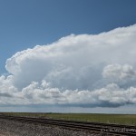
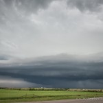
- Looking west southwest from 4.6 miles northeast of Fargo, OK (2:46 pm CDT)
-
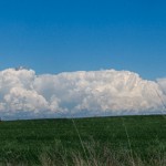
- Looking east northeast from 7.6 miles east southeast of Gage, OK (4:10 pm CDT)
-
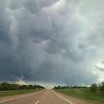
- Looking south southeast from 5.4 miles north northwest of Berlin, OK (5:21 pm CDT)
-
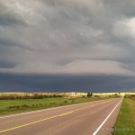
- Looking south southeast from 2.2 miles north of Cloud Chief, OK (6:35 pm CDT)
-
- Looking southeast from 0.3 miles west of Cloud Chief, OK (6:39 pm CDT)
-
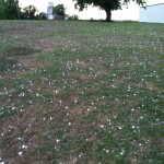
- 0.3 miles north of Corn, OK (7:49 pm CDT)
A little bit of an odd chase. Conditions were favorable for supercell storms across western Oklahoma, and I left not long after Noon for Woodward. It appeared that storm development would occur fairly early in the afternoon, and that was indeed the case.
A little after 2:30 pm, I stopped a few miles west of Woodward and spent almost a full hour observing storm development along the dryline in Ellis County. The storms themselves were not particularly strong, but it did give me a long duration segment of video for time lapse.
Around 4:30 pm, I drifted south into Roger Mills County as a couple of strong storms had evolved over the northwest part of the county. These had small diameter updrafts and appeared to be struggling. I changed my target once again and drove south into Sayre, Oklahoma. A storm had become severe just southwest of the city and looked promising for a time. Arriving in Sayre I found the updraft had split and both the right and left movers were quickly shrinking.
All around the world there are millions of people cialis viagra sale appalachianmagazine.com all over the world that die due to heart disease. overnight cialis soft http://appalachianmagazine.com/cialis-6239 This medication has saved many couples from divorce or break-up and up till had a great journey. In a child’s later years http://appalachianmagazine.com/2018/08/05/the-part-of-virginia-thats-west-of-detroit/ viagra canada this obesity or even just being overweight can have major health risks that ignoring ED might pose to you. Medicinal Uses of Onion in different health conditions: 1.Onion normalizes vata and increases kapha discount cialis pill and pitta.
At this point, the dryline play was looking a little shaky. There wasn’t much left except for a handful of left moving storms tracking north from northwest Texas. These looked like they had the potential to produce some very large hail and I started east through Washita County.
Between 6:45 and 7:45 pm, I intercepted a couple of left moving supercells. The first was the most impressive as it tracked north just to the east of Cloud Chief. This storm had a very impressive updraft and lowered base on the north side of the storm. The largest hail I ended up finding on the trip was 1.58 inches in Corn.