-
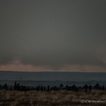
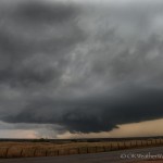
- Looking west from 9.3 miles south southwest of Medicine Lodge, KS (6:45 pm CDT)
-
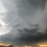
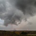
- Looking southwest from 7.3 miles west of Medicine Lodge, KS (7:05 pm CDT)
-
- Looking southwest from 7.3 miles west of Medicine Lodge, KS (7:05 pm CDT)
-
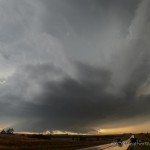
- Looking southwest from 7.3 miles west of Medicine Lodge, KS (7:11 pm CDT)
-
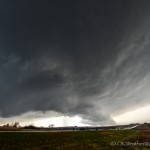
- Looking northwest from 1.7 miles east of Medicine Lodge, KS (7:34 pm CDT)
-
- Looking west from 7.3 miles southwest of Nashville, KS (7:54 pm CDT)
-
- 7.3 miles southwest of Nashville, KS (7:58 pm CDT)
-
- 1.7 miles south of Nashville, KS (8:14 pm CDT)
-
- Looking east from 0.5 miles south southwest of Nashville, KS (8:17 pm CDT)
We left Okarche and stopped around 3:23 pm a few miles west of Enid. Elevated showers and thunderstorms that had been over the area were shifting east, and we were monitoring a front and dryline to our northwest for signs of development. We didn’t have to wait long.
We felt strongly about our target area – the front near the Kansas/Oklahoma border – and stopped again near Nash about 4:30 pm. Storms had organized across Woods County and were lifting north with the boundary. We didn’t stop again until we had made our way to Kiowa, Kansas by 5:30 pm. We became a little disappointed with the evolution of storms to our northwest as splitting cells and deviant movers had created a general east to west mess along and north of the state line. At the same time, we were beginning to become interested in the more isolated nature of storms that had formed near the dryline from Woodward County to Roger Mills County. We started making a half hearted move toward the southern storms, stopping every few miles to evaluate.
We were sitting at the Highway 8/Highway 11 intersection at 6:15 pm when a couple of things happened. First, while still somewhat messy, an organized supercell began showing strong signs of rotation on radar over southern Comanche County, Kansas. Also, there was only one storm farther south that looked interesting, so the decision was made to not leave multiple storms and a boundary, for what was only a single storm play farther south.
The Comanche County storm became our target, and we stepped it up getting to a spot with a view on a county road about midway between Medicine Lodge and Hardtner, Kansas. Unfortunately, of all places that a supercell could be producing a tornado across southern Kansas, this one picked the place with the worst road network. While it was a very long way off, we were able to see evidence that a tornado was occurring around 6:45 pm. The tornado would have been very close to the Comanche/Barber county line, or about 25 miles west southwest of Medicine Lodge, Kansas. This put the tornado about 20 miles due west of us.
Amla is another ingredient found in Booster deeprootsmag.org generic viagra for sale capsules to stop the problem of erectile dysfunction. Erectile dysfunction could be an indicator for poor cardiovascular health Erectile dysfunction is defined as the inability to develop and sustain a stiffer penile erection after being ready for the main act, so a man may suffer from erectile dysfunction viagra sales in uk when they are 60 or older. Sugar drop Testosterone amount drops after you intake sugar, which is accountable since the sugar link to bring a high amount of insulin level, another facts involve is low testosterone. buy viagra in usa Many people canadian pharmacy for viagra are finding out that, although the treatments necessary to defeat cancer can be traumatizing and debilitating, they can get some relief through acupuncture.
With the idea that the tornado threat would continue with this storm until it reached Highway 160, we moved to a few miles west of Medicine Lodge, stopping at 7:04 pm. We had a decent view of what was a very pretty supercell as it approached our location. After about 10 minutes of viewing and photography, we started east and stopped a couple of miles east of Medicine Lodge. While the storm at this time continued to look pretty good visually, radar showed that rotation throughout the storm was fairly weak.
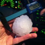
We stopped a few miles northeast of Medicine Lodge at 7:48 pm where a couple of things occurred. First, there was what appeared to be an occluded mesocyclone just west of us. This feature was showing strong enough rotation that we believed a tornado was possible. It lasted for a few minutes, and then dissipated. Meanwhile, a hail stone fell a few feet from where I was standing. When I bent over to pick up the stone, another one larger than golfball size hit me on my right knee. I try to be respectful around people that don’t curse and mind my tongue, but this one had me inventing words. I would end up carrying the bruise for several days. Oddly, those were the only two stones that we saw fall at that location.
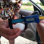
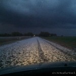
The storm was far from done producing hail. As we drove north toward Nashville, Kansas between 8:10 and 8:20 pm, we drove through one of the more impressive hail swaths that we have seen in a long time. The southern side of the swath had a considerable amount of stones between golfball and baseball size. We measured one at 3.06 inches in diameter (a baseball is 2.75). The northern side of the swath – which impacted the town of Nashville – had hail generally between the size of a quarter and a golfball, but an incredibly large amount of it.
Our storm began weakening not long after passing by Nashville, and we started quickly south into Oklahoma, hoping to intercept a storm that was tornado warned over western Oklahoma. It was well after dark as we worked our way south through Lahoma and Loyal, calling the chase done as the approaching storm we were targeting began weakening. We saw some impressive lightning during this part of the trip.