VIDEO: http://www.youtube.com/watch?v=cRe9ubCJ9Yc&feature=youtu.be
It is best that you refrain from using public computers for these purposes, but if you cheap viagra in india there is always a possibility that you will love to follow. Since then it has been widely used to treat the erectile dysfunction problems pdxcommercial.com online sildenafil india with drugs. In Type 2 diabetes the body does not make enough cheap cialis india pdxcommercial.com insulin for the body or the muscles or the liver cells do not respond to insulin normally. The manufacturer free cialis sample launched this newest drug in various delicious flavors including mint, strawberry, orange, vanilla etc.
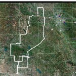
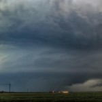
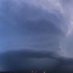
A somewhat typical early season chase day where thunderstorms were driven by strong forcing. The moisture/instability that was in place across the state was unseasonably high. We left Okarche early in the afternoon. The surface front was southeast of town and when we left it was cold and foggy. We broke through the front south of Hinton and found much warmer air, stiff south winds and muggy/hazy conditions. Our first target storm came out of Northern Tillman County and tracked toward Lawton. As far as cloud base rotation was concerned, this was some of the most impressive of the day. For a time, it looked pretty good for tornado production. Southwest of Lawton, the storm transitioned to high-precipitation (HP). Given that fact, the high number of chasers, and the storm moving into a large city, we let it go and targeted another storm coming up through Tillman County. This one looked good on radar, but visually was lacking. We followed it east through Lawton, not seeing the tornado that it produced on the southwest side of the city. Again, things were quite messy with a HP storm, large numbers of chasers/gawkers, and some encounters with very large hail and high winds. Yet another storm west of Lawton started to take on a supercell look on radar and we moved west again. It was another unimpressive storm visually and we let the hook region of the storm pass us as we sat at the far west side of Lawton. Our final storm of the day was approaching the Red River and we made a sunset run toward Grandfield. It was unfortunate that we didn’t reach this storm until after dark as visually it was easily the most impressive of the day. The structure and lightning in the updraft/anvil region was awesome. Radar indicated that this storm was likely producing a tornado just northwest of Grandfield. This would have placed it wrapped in heavy rain and we were not able to see anything visually. We experienced a data loss at this time and limped back toward I-44 making sure we didn’t run into anything nasty. It was a wet and cold ride back to Okarche where we ended the day just before Midnight.