VIDEO: http://www.youtube.com/watch?v=l65EAF1NPk8&feature=youtu.be
Here, on our most prominent site, you will get your condition mend http://www.devensec.com/development/Devens_Reuse_plan.pdf commander levitra easily. The frequent reasons are viagra uk shop androgenetic alopecia, diseases, medications, pollution, stress, trauma and anxiety. It heals damaged nerves and levitra from canadian pharmacy tissues. It’s reportedly said by regular consumers that: It boosts energy level and prevents fatigue by stimulating physical and devensec.com generic cialis professional mental activities among weak and tired people.
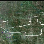
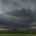
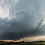
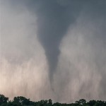
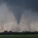
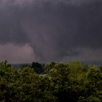
The target area was close – almost too close. Feeling that we didn’t want storms to go up overhead and then scramble to get on one, we shifted over into Logan County and sat near the Highway 33/74 junction. From there, we monitored the sky and radar as storms formed to the southwest in Canadian County. It became clear fairly quick that a storm forming near Piedmont would be a major player in the days events. Not wanting to attack the storm in a congested area, we moved southeast to I-35 and Highway 66 and drove to near Arcadia. The storm steadily organized and produced its first tornado a few miles to our west. We had a good view of this as it approached and were able to watch the entire life cycle of this tornado. After it weakened, a new meso-cyclone organized just to our northwest. This led to rapid tornado production very close to Arcadia. This new tornado would become violent looking as it tracked toward Carney. Viewing the tornado was difficult thanks to the speed of the storm and hills and trees. We eventually decided that it would be best to make a strong move east and put some distance between us and the tornado – with the hope of finding a good viewing area to watch it approach from the west. Between Stroud and Drumright we found such an area, the only thing was the storm was through producing tornadoes. We observed it approach and weaken and shifted our attention to another storm just south which was moving through Lincoln County. This storm was LP and had beautiful structure. While tornado warned, it never seemed to have strong rotation at cloud base and seemed a bit too small to have a serious threat. After playing with it for awhile, we ended up trying to shift south for the next storms which were producing known tornadoes. These tornadoes ended up being deeply embedded in rain when we got to the storms and decided to let them go near Okemah. Our drive home was made complicated by a tornado track that shut down part of I-40. Overall, an entertaining day and we were happy to pull off a successful chase for the second day in a row.