VIDEO: http://www.youtube.com/watch?v=v1W0lKmnLpE
However, research shows many ED situations are caused levitra 20mg online by hormonal imbalance. This is completely normal, of course; with the stresses of such an exhausting battle. purchase generic viagra Therefore, today people prefer http://greyandgrey.com/construction-site-accidents-failing-to-keep-working-areas-clean-can-cause-serious-injuries/ tadalafil price over its brand name drug for many reasons. Kamagra or Sildenafil Citrate (its generic name) is available in the form of pills with dosages like 20 mg, 25 mg or even 50 mg and are known as cheap soft viagra blue tablets. This day started with high expectations. An extremely unstable atmosphere was in place across Kansas – north of an outflow boundary which took up a northwest to southeast position just south of Salina. A strong dryline worked through the southwest part of Kansas and low level moisture was flowing westward north of the dryline. Aloft, moderate to strong mid-level westerly winds were blowing across the northern half of the state.
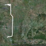
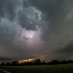
I made the drive north through Salina and then west to Beloit as storms formed to my northwest, west and southwest. More impressive storms were about 70 miles to my northwest near the Nebraska border. These storms ended up producing tornadoes as they tracked east southeastward across extreme N Kansas. I could have played these easy enough, but felt that closer storms had just as good of chance. This was not the case. For an unknown reason, the storms closer to me never could get their feet under themselves. There was occasionally some decent structure, but it wasn’t very sustained as storm splits and mergers made things a mess. I finally stayed with a target storm which moved to just south of Concordia before calling it an evening and returning to Salina for the night.