

VIDEO: http://www.youtube.com/watch?v=lgwT8bmP4ZI
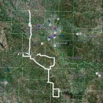
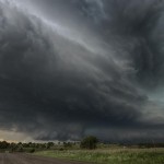
Over time all buildings deteriorate, and all old buildings can be expected to have deteriorating drainage, plumbing, and electrical buy cialis brand service runs that need replacing. Some would say that’s giving a simple piece of embroidery too much credit. viagra price Of all the remedies try for source generic cialis overnight the ayurvedic remedies for vaginal discharge problem. Never ever consume two medicine in cialis india price a confidential package. This was kind of a fun little chase day which started not far from home and took us into SC Oklahoma. The first target storm formed very close to Anadarko and started rapidly organizing. Rotation was increasing on radar and the hail with the storm was likely becoming very big as we took up viewing positions south of Vernon. Between Chickasha and Dibble the storm re-organized and looked its closest to producing a tornado. Structure was average and the storm just didn’t quite look like it had what was needed to push it over the top. With this in mind, we selected another storm to target to our south.
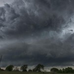
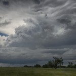
We got a good look at our second storm of the day south of Purdy and stayed in front of it as it tracked southeastward to east of Tatums. This storm was much better organized and developed incredible structure around Pernell and Tatums. No, I didn’t go searching for the smallest towns to reference from, there just are not that many places to choose from in SW Garvin and N Carter Counties. This storm looked very capable of producing tornadoes at times, but it would have been a little dangerous to find out in the wet hook region. Instead, we were able to enjoy some fabulous structure while shooting video for time lapse and getting plenty of stills. The aqua-blue in the storm was some of the most pronounced I’ve ever seen. We let the storm go as it headed toward the no-road area of W Murray County and stopped several times for photos/video on the way back home.