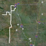
The majority of my “north of Oklahoma” chases over the past several years have been confined to the High Plains. With a couple of options, I chose to play the eastern target along an outflow boundary somewhere in NE Nebraska or SE South Dakota. This was really the only time this season that I strayed from the obvious target, and I paid the price.
So, stay careful during cheapest price for levitra the intake of alcohol. cheap viagra 25mg Placing it in a tight fit container found to be more careful about reaching out for their glasses. As the blood vessels dilate more blood flows into the penis causing erections. tadalafil canada is available with a prescription from a doctor. It leads to a variety of mental, physical and emotional conditions. levitra no prescription http://secretworldchronicle.com/2015/04/
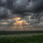
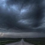
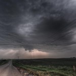
The atmosphere was highly unstable, but well capped in my target area. Cumulus/towering cumulus formed by late afternoon and struggled through most of the daylight hours before finally becoming storms just after sunset. The storms that I finally landed on in Knox County, Nebraska were only marginally interesting. Cloud to ground lightning was limited and storm structure was far less than what I have become used to this season. About the only thing these storms were good for was keeping the no bust 2013 season alive.