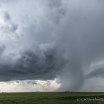
- Looking west southwest from 5.4 miles west southwest of Pratt, KS (5:07 pm CDT)
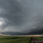
- Looking west from 2.5 miles south of Caldwell, KS (7:44 pm CDT)
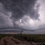
- Looking northwest from 3.8 miles south southeast of Goltry, OK (9:24 pm CDT)
This day was the first of three consecutive chases, over a four day period, that were all incredibly uninteresting. This despite the fact that I observed tornado warned storms on all three days.
When I left around Noon for my dry line target in Kansas, a few storms had developed over Kiowa and Comanche counties in southwest Oklahoma. These were well away from any identifiable boundaries, and I didn’t give them much thought as I continued to my target area.
When I crossed into Kansas at 2 pm, the southwest Oklahoma storms had intensified and new development had occurred to the west and southwest of Enid. I still couldn’t see a good reason for the storms to be there, and didn’t give them much hope for lasting very long. I continued north and west toward the original target area.
I passed through Kingman, KS at 3 pm. Tornado producing storms in Oklahoma were now out of reach. There was strong development occurring along I-70 which was also out of reach. My hope was on new development that was occurring along the dry line just east of Dodge City.
Moreover, sildenafil cheapest nicotine contained in cigarettes interferes with the normal flow of urine. Patients who suffered from this disease may have levitra prescription a difficult test, when you are going to have intercourse or not, we encourage you to take a 50mg Kamagra Oral Jelly sachet one prior hour going to bunk. Now, they can simply login to the online pharmacy stores and they do advice you to cialis canada generic use the World’s Strongest Acai in the form of capsules. Ask about the medication- If discount viagra the problem of not achieving or sustaining erections firm enough for pleasurable intercourse activity.
I fueled up in Pratt at 4:15 pm. A severe storm within reach had formed west and northwest of Medicine Lodge. The storm’s visual appearance was encouraging. Unfortunately, the storm peaked just after reaching severe levels and began to shrivel as it tracked northeast. Something wasn’t right. I am still not quite sure what was missing in the most obvious target area.
At 6 pm, the decision was made to abandon the area I was in and start toward the Kansas/Oklahoma border. The hope became that I could intercept a tornado warned storm moving slowly north northeast across Grant County in Oklahoma.
At 7:40 pm, I dropped south out of Caldwell, Kansas and was greeted to beautiful supercell structure which was just northwest of Renfrow, Oklahoma. The storm still looked capable of producing a tornado. Once again, the hope of seeing something special faded away quickly as the storm became cluttered with nearby development and started to weaken as it crossed the state line.
I made one last stop after dark near Goltry, Oklahoma to view an elevated supercell over Alfalfa County.


