-
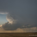
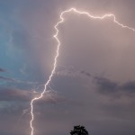
- Looking west from 1.7 miles west northwest of Grandfield, OK (4:57 pm CDT)
-
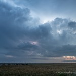
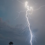
- Looking southwest from 5.3 miles southeast of Omega, OK (8:56 pm CDT)
-
- Looking southwest from 5.3 miles southeast of Omega, OK (9:31 pm CDT)
-
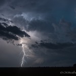
- Looking southwest from 5.3 miles southeast of Omega, OK (9:26 pm CDT)
-
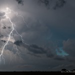
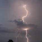
- Looking northwest from 5.3 miles southeast of Omega, OK (9:01 pm CDT)
-
- Looking northwest from 5.3 miles southeast of Omega, OK (9:03 pm CDT)
-
- Looking northwest from 5.3 miles southeast of Omega, OK (9:07 pm CDT)
The greatest risk of severe weather was near the Red River, and we drove south to the Grandfield exit on I-44. We spent a good amount of time observing a couple of low precipitation supercells to the south of Hollister and west of Grandfield. The storms struggled and became interfered with by outflow from storms south of the Red River. We began working our way back toward home around 6:30 pm.
If the day had ended there, it would have been a rather uneventful outing. But the day wasn’t over as storms started forming from northwest to southwest of Oklahoma City during our trip back.
We ended up observing numerous thunderstorms (some severe) organize in Blaine County. We had a one hour stop just southeast of Omega where we were treated with spectacular lightning near and just after sunset.