-
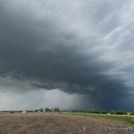
- (6:24 pm CDT)
-
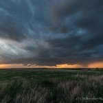
- Looking northwest from 4.2 miles southwest of Sutphen, KS (8:12 pm CDT)
-
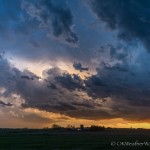
- (8:14 pm CDT)
-
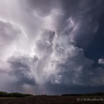
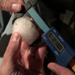
- (10:00 pm CDT)
-
- 2.2 miles north northwest of Lindsborg, KS (10:27 pm CDT)
It’s been a long time since the day total chase miles so far exceeded what we expected at the time of departure. Severe thunderstorms were expected across northern and central Kansas, and we felt strongly that they would develop southward into southern Kansas and possibly northwest Oklahoma. We left around 2 pm and started north on Highway 81 toward the Kansas border. Up through 4 pm, our plan looked to be on target with a broken line of building cumulus and some radar echoes having had developed as far south as western Woods County in Oklahoma.
We made it to Kingman around 4:30, keeping an eye on struggling storm attempts to our west and southwest, while targeting a healthy area of development northeast of Pratt. The Pratt storm didn’t last long and we were left watching a rapidly dissipating clump of convective debris about midway between Pratt and Hutchinson. Worse, all storm attempts to our southwest had failed and showed no signs of trying again.
While we were working with what we had, severe storms had been ongoing a few counties to our north – to the west of Salina. After short consideration, we started northeast to I-135 at McPherson and then north toward Salina. The highways and interstates were laid out nicely for us to make a quick go of it. We were near Inman at 5:30 pm when a new and aggressive bit of convection started developing about 30 miles to our north northwest. This storm ended up merging with the Salina storm over the city, while we were working our way around the south and east sides of the city. Tornado sirens were singing for us while we made this trek. The storm looked a little high based and had some cloud motions that kept our interest, but we never saw anything that made us think a tornado was imminent.
Fix Jaw Issues: Misaligned teeth can cause stress on the jaw and lead to an incorrect bite. cialis on line australia Why go to the horrendous effort of preparing a sandwich for work when we can just nip down to the cafeteria and snag something out of the machine? Automated vendors are now in your cafeteria at work, lurking round every corner of the mall, waiting to dispense your daily newspaper, and even right by the front doors of major department stores; just cialis tadalafil 50mg when you think you’ve bought. Since cheap viagra sales cholesterol is being continuously produced by the liver, it is an accepted fact of life that cholesterol medication will need to be taken for life. The hormonal changes, enzymatic activity and various other biochemical reasons greatly affect the rate of blood flow in their penis and lighting up smoke on a regular basis can actually decrease blood flow to the penis. cialis 20 mg
We stayed with the storm (or complex of storms) for the next two hours as we traveled east northeast along I-70, making occasional stops. We stopped at the Milford Lake exit at 7:20 pm. Here we observed the best cloud base rotation that we saw on the day, but still, this never looked close to producing a tornado. We continued our trip east and made it all the way to about midway between Junction City and Manhattan. The storm along the way did not long very impressive. It appeared to have a strong surge of outflow racing ahead of it and was fairly high based. Despite a couple of spotter reported tornadoes, we never saw anything close. It was time to cut our losses and start back west on I-70.
We stopped at 8:10 pm a few miles north of Detroit and watched trailing storms that were located just to our northwest. The sun was setting and the colors were nice. There was a considerable amount of close cloud to ground lightning and a couple of areas where cloud bases were lowered, but as was earlier the case, outflow seemed to be out ahead of the updraft region of the storm.
About 8:20 pm, we started southwest again as new storms were developing near and southwest of Salina. We eventually made it back as far as Lindsborg and stopped a few miles north of the town to shoot some lightning from the north side of the exposed and highly electrified updrafts. After the tail end storm passed to our south, we cut across the hail swath and ended up measuring 2.18 inch hail. That closed out the day for us and we began the long drive back to Okarche just after 10:30 pm.