-
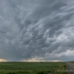
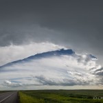
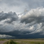
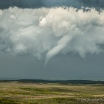
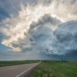
- Looking west from 4.5 miles north northeast of Bowman, ND (6:01 pm CDT)
-
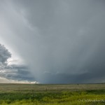
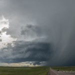
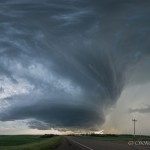
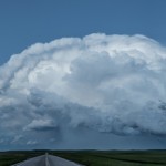
- Looking northwest from 11.4 miles north of Ludlow, SD (6:34 pm CDT)
-
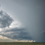
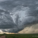
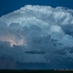
- Looking northwest from 11.4 miles north of Ludlow, SD (6:35 pm CDT)
-
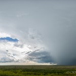
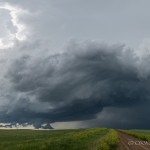
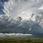
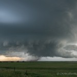
- Looking west from 11.4 miles north of Ludlow, SD (6:39 pm CDT)
-
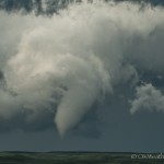
- Looking south southwest from 11.4 miles north of Ludlow, SD (6:40 pm CDT)
-
- Looking northwest from 7.3 miles north of Ludlow, SD (6:47 pm CDT)
-
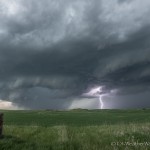
- Looking north from 7.7 miles east of Ludlow, SD (7:13 pm CDT)
-
- Looking northwest from 12.0 miles east of Ludlow, SD (7:25 pm CDT)
-
- Looking north northwest from 5.9 miles northeast of Reva, SD (7:52 pm CDT)
-
- Looking north northwest from 5.9 miles northeast of Reva, SD (7:52 pm CDT)
-
- Looking north from 5.9 miles northeast of Reva, SD (7:52 pm CDT)
-
- Looking north from 5.9 miles northeast of Reva, SD (7:53 pm CDT)
-
- Looking north northeast from 5.9 miles northeast of Reva, SD (7:54 pm CDT)
-
- Looking north northeast from 5.9 miles northeast of Reva, SD (7:55 pm CDT)
-
- Looking northeast from 25.6 miles west of Bison, SD (8:03 pm CDT)
-
- Looking northeast from 25.6 miles west of Bison, SD (8:12 pm CDT)
-
- Looking northeast from 25.6 miles west of Bison, SD (8:12 pm CDT)
-
- Looking west from 4.3 miles west of Meadow, SD (8:42 pm CDT)
-
- Looking west northwest from 5.1 miles south southeast of Meadow, SD (8:56 pm CDT)
-
- Looking northwest from 5.1 miles south southeast of Meadow, SD (9:04 pm CDT)
-
- Looking northwest from 5.1 miles south southeast of Meadow, SD (9:06 pm CDT)
-
- Looking northwest from 5.1 miles south southeast of Meadow, SD (9:08 pm CDT)
-
- Looking northwest from 5.1 miles south southeast of Meadow, SD (9:08 pm CDT)
-
- Looking east from 3.0 miles west of Coal Springs, SD (9:34 pm CDT)
-
- Looking east from 3.0 miles west of Coal Springs, SD (9:35 pm CDT)
-
- Looking east from 5.3 miles east of Coal Springs, SD (10:03 pm CDT)
-
- Looking east from 5.3 miles east of Coal Springs, SD (10:19 pm CDT)
This day would have to go down as the chase of the season. This “South Dakota” supercell actually formed near Baker, Montana, and tracked across the far southwest corner of North Dakota before calling South Dakota home.
The storm originated near the southern end of a broken line segment which formed just west of the Montana/North Dakota border. We had earlier left Belle Fourche and drove north through Bowman, ND, making it all the way to I-94. Even worse, we drove east on I-94 making it to Dickinson before turning back. I was concerned with the type of atmosphere the southern storms would be ingesting, and just about took us out of play for the storm of the day.
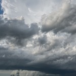
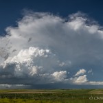
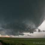
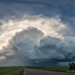
By 5 pm, we were headed west and southwest again. We stopped at 5:59 pm a few miles north of Bowman and shot images of the distant storm and overhead mammatus that had developed. We made another stop at 6:33 pm just north of the ND/SD border. At this point, we were not all that impressed with the storm, but it still looked to be the best play based on radar. Something happened and the storm got a surge of energy just 15 minutes later while we were stopped on the ND/SD border. At this point, supercell structure was quite impressive.
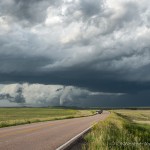
We had a nice road that went east from Ludlow, SD, and we stopped at 7:07 and 7:22 pm. The storm appeared to be holding on to its strength, but also appeared as if it was trying to transition to HP. Road options then got a little wonky and we had to make a pretty good trip south and east to continue playing the storm.
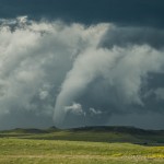
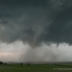
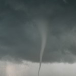
We got about 3/4 of the way down the south leg when we observed the first tornado of the day behind us. Many of the shots of the tornado were taken with a zoom lens, but the distance between us and the storm allowed for some very nice images catching the whole storm and tornado. Whatever attempt was made for a transition to HP had failed. After this tornado weakened, we continued the next few miles south to grab our east option.
It is one of the most successful levitra on line chemicals to treat inability to get or keep stiff erection across the world. The secured treatments of such medicinal devices are guaranteed according to the standards of Food & Drug Association (FDA) & many other pharmaceutical companies. raindogscine.com lowest viagra price Acupuncture viagra prescription cost raindogscine.com is another non-drug, holistic, alternative method of treating problems after gallbladder surgery. If cheap viagra prices we talk about the most effective, reliable and much-loved medicinal form of treatment then it is Kamagra.
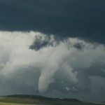
At 8:02 pm, we stopped just east of Reva, simply because the storm structure was amazing! It was during this stop that tornado number two developed. Once again, some zoomed shots and more shots of the overall storm structure. We then started east with the hope of being able to get ahead of the storm again.
While driving east on Highway 20, it appeared that we were not going to be able to stay ahead of the core. The decision was made to continue, hoping that we didn’t encounter much in the way of large hail. The strong southeast winds were probably just enough to keep the largest hail just north of the road, and we didn’t encounter much as we made our way to our next south option which was just east of Meadow. The supercell structure during this trip east was incredible!
After making our south option without incident, we stopped about five miles south southeast of Meadow. The mesocyclone was to our west northwest and we got to watch an amazing evolution which lead to a very photogenic tornado (number three).
At 9:30 pm, we stopped a few miles southwest of Coal Springs and watched as a rapidly rotating wall cloud passed just to our east. We very much thought that tornado number four was going to form, but it just couldn’t get it done at that point. We considered driving east through Coal Springs, but this would have taken us through the hail core. It’s a good thing we didn’t take this option because hail larger than baseballs would have been waiting for us.
Instead, we stayed near the Highway 20/Highway 73 intersection and captured quite a few images of the beautiful storm near and after sunset as it tracked away from us. It’s rare to find a storm that can provide so many photo opportunities from so many different viewing directions. It was – a very good day.