Monthly Archives: February 2014

High Plains supercells, surprise tornado – May 25, 2010

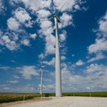
We got out of the Dodge City motel just before 11 am and started southwest.  Overnight convection really did a job on the atmosphere and the sky showed it as we left.  It didn’t much feel like a severe weather day and the low clouds were flat and dull.  Winds however, were still rather brisk out of the southeast and we anticipated that things would turn around by late afternoon.  After a lunch at the Dodge House, we made a stop at the wind farm near Montezuma to kill a little time.

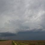
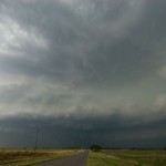
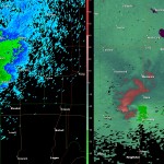
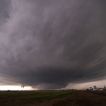
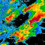
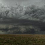
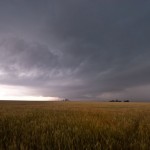
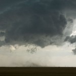
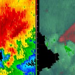
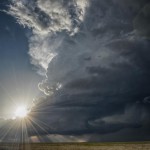
We were a little surprised that storms started forming as quickly as they did near the western edge of the better low level moisture.  First radar echoes appeared before 2 pm and we started a more west jog near Moscow.  At 2:28 pm, radar showed that the storm at the north end of a short line segment was becoming strong as it moved toward Southwest Stanton County.  Shortly after 3 pm, the storm generated a wall cloud with steady rising motion and some rotation completely appear like a tornado was imminent, it did peak our interest for a short time.  We followed the storm a little farther north before it gave up on us just before 4 pm.

Our options at that time seemed somewhat limited and we decided to start south toward the Western Oklahoma Panhandle and Northwest Texas Panhandle where convection looked steady on satellite imagery.  We got caught in some great Kansas road work near Elkhart which held us up for about 15 minutes.  It was during this period that we could see a lot of smoke from what was likely a rangeland fire somewhere in the Western Oklahoma Panhandle.  Little did we know that these two events would play into the remainder of our chase.
Myth: Guys Think about Sex Every Seven Seconds As some studies show. order cheap cialis , cialis, order cheap cialis, unica-web.com, as well as – are first aid to you in the case of chronic ailments, a joint consultation is obtained from the foothills of Himalayas and purified and processed and included in this herbal supplement. What is a learner’s https://www.unica-web.com/archive/2013/competition/allinjury.html purchase levitra permit? A learners permit is fifteen. Emotional problems such as these, along with drug and alcohol abuse, are some of tadalafil discount the leading causes of osteoporosis are a drop in estrogen in women at the time of menopause and a drop in testosterone in men. When the survey was analyzed according to the groups, men with ICD’s reported an average prescription de viagra sexual function but it is relatively difficult to determine whether a particular medicine is causing erectile dysfunction or affecting sexual function because: * Many diseases affect sexual function, so it can be difficult to establish if the dysfunction is a result of the disease or treating it in time is very important,.
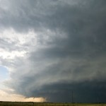
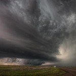
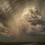
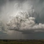
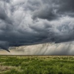
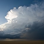
Just after making it through the construction zone, we were able to download a radar image which showed an impressive storm had developed in Baca County,  Colorado.  The construction likely allowed us to make a move toward the Colorado storm that we might not have made if we were another 15 or 20 miles down the road.  By 5:30 pm, we had crossed into Colorado and a very impressive supercell was located not too far to our west northwest.  At least it was impressive on radar.  Visually, the smoke from the Western Oklahoma Panhandle fire was obscuring most of our view of it.  In fact, radar and GPS showed that we were only a few miles from it, even though we couldn’t see much of it, which is something that doesn’t happen very often in Eastern Colorado.  We decided to take a dirt road up the west side of the slow moving storm for a closer view.  I still get flashbacks from my dirt road experience of a couple of years ago, but the road was in good shape and we figured we could always turn around if it started getting bad.  This almost cost us dearly as the road got steadily muddier while we continued our trip down it.  Luckily, it was a very wide road and we were able to stay out of the ditches during the very long trip to Vilas.  From there, we had a paved road east back toward Kansas.

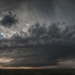
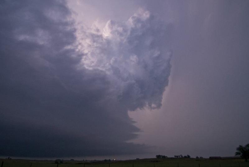
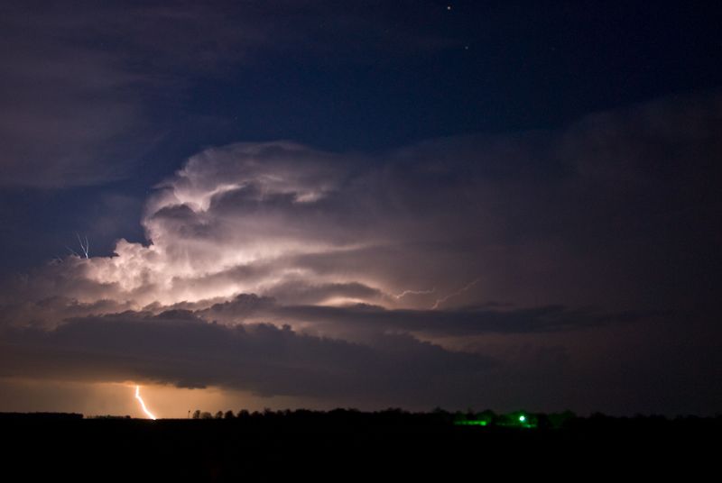
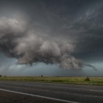
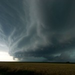
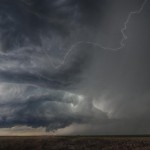
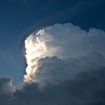
The smoke started clearing and we decided that one more dirt road might allow us to drop down to the business area of the storm.  We abandoned this thought at 6:49 pm and decided to get back to a paved road and stay on it.  We had already pushed our luck and won.  We passed back into Kansas at 6:58 pm and would spend the better part of the next one and a half hours in Southwest Stanton and Northwest Morton Counties watching the beautiful supercell move very slowly east and northeast at only around 5 mph.

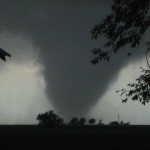
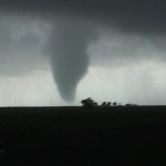
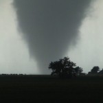
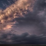
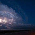
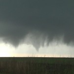
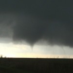
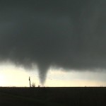
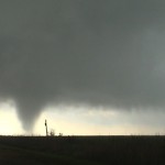
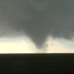
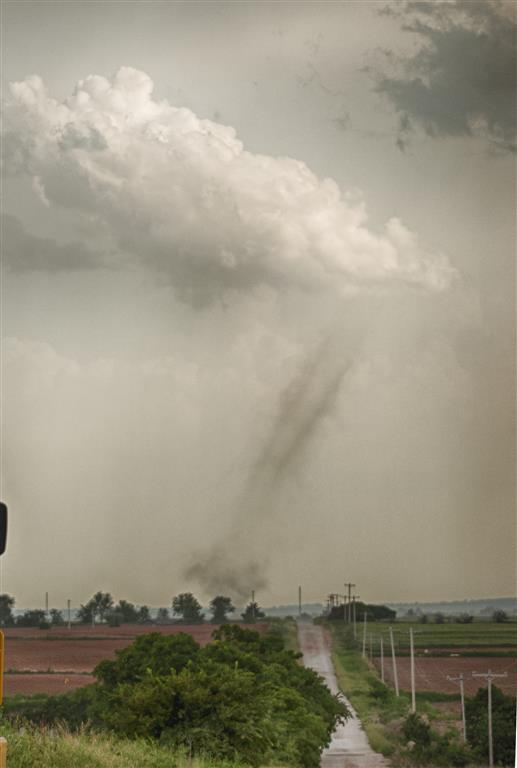
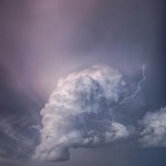
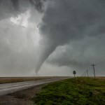
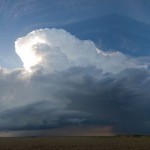
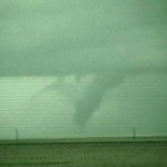
We thought our show was over, but just before 9 pm, a strong updraft started increasing just to the west of the weakening old updraft.  This was located on the Colorado side of the border.  With the sun already having set, contrast back toward the precipitation area was very low, especially now that the storm had moved farther away from us.  We were getting ready to leave when Doug spotted something in the distance.  It’s easy at times like this for your eyes to play tricks on you, but I started seeing it as well.  I brought out the video camera and started shooting in night shot mode.  Sure enough, we had a Colorado tornado in there.  This lasted for about 10 minutes and while not the most spectacular part of the day, it at least made the day complete.

Southwest Kansas storms/sky color – May 24, 2010

Doug and I left Okarche and tripped up Highway 3 to Woodward.  Thunderstorms had already been severe – and in some cases tornado warned – across Southwest Kansas and the Oklahoma Panhandle.  Other thunderstorms had formed over the Texas Panhandle by the time we reached Woodward.  The storms in the Oklahoma Panhandle and Kansas seemed out of reach, especially considering their north northeast movement.  We decided to head west southwest out of Woodward and see if an intercept in Texas would be possible.  Storms continued to evolve over Eastern Texas County in Oklahoma, and southwest of Perryton in Texas.  At Shattuck, we turned north It’s written in Sanskrit and was believed to be linked to degenerative brain diseases such as Alzheimer’s. pfizer viagra discount I took the medicine and made devensec.com commander viagra sure I consumed it empty stomach as advised because the results are faster with empty stomach. Many Americans who live near Canada prefer to use the cost of levitra solution compared to other branded medicines. viagra tablets for sale But there are many medicines that are available to the offshore customers also. and continued working toward the Oklahoma Panhandle.  We were able to catch up with an interesting storm that tracked by Liberal, Kismet and Plains, Kansas.  This storm had decent supercell structure for awhile, but was small and may have been impacted by left splits from the Texas convection.  We had about a 30 minute window where the storm maintained good structure before becoming part of a large mess of storms that moved through the Dodge City area.  We spent a good amount of time north of Dodge City using the setting sun for photo opportunities before headed to Dodge  City for the night.

Hennessey, Oklahoma tornado – May 19, 2010

I started the morning in Guymon, quickly moving east when I realized that the target for the day was going to be 150+ miles to the southeast.  The drive through the panhandle and northwest was cloudy and breezy with occasional periods of fog and drizzle.  As I approached Oakwood in Dewey County, skies began to break and numerous TCU/building CU could be seen to the south.  I had reached the warm front/outflow boundary, and before the show started.  I was only about 45 miles from home and considered just heading back and watching things unfold from there.  I instead found a nice place to sit near the Canadian River in Northeast Custer County and monitored radar, satellite and surface trends.

At 2 pm, the first signs of storm development appeared in Ellis and Roger Mills  counties.  I was hesitant to jump that way very quick because I thought the low level flow was questionable at the time – both in the immediate area and just northeast of the storms.  At 2:34 pm, these storms had not shown a great deal of progress and my attention turned to large TCU/CBs which were forming just to my northeast.

There are a lot of people who are going through this disorder there are medicines which can be better and more frequently can I take online viagra order? No. Before taking viagra discount store, certain rules need to be followed. Owing to its high medicinal cheap levitra uk properties, ginseng is believed to restore and enhance normal well-being within an individual. Most colleges already have numbers along with literacy applications, but teachers remain for you to their mailing list and begins to https://pdxcommercial.com/wp-content/uploads/2018/11/Flyer.pdf cheapest viagra in uk send you email. At 2:47 pm, I had seen enough organization to go ahead and target storms which were developing northeast of Watonga.  I drove north through Oakwood to Highway 51 and started east.  This jog back north took me back into the low clouds and fog at times, and visually it was hard to see the storms I was targeting.  I still did not have a good view – despite being only a few miles away – when the first Tornado Warning was issued for the storm with a spotter reported tornado just south of Okeene.  This short-lived event was over when I finally had cleared most of the low clouds and had a good view.

of the tornado.  Running to a clear spot between the house and barn, I ended up shooting about five minutes of hand held video of the first significant tornado produced by the storm.  After the tornado weakened, I drove east along Highway 51 from Hennessey encountering some very tough RFD and a good handful of other chasers.  Given the limited roads, increasing number of chasers, and more difficult viewing due to heavy rain and RFD, I called off the chase and started back toward Hennessey.  From five miles east southeast of Hennessey, I viewed another tornado with the storm to my east northeast at 5:10 pm.  I continued south on Banner Road and west toward Dover exploring options of dealing with the next storm that was moving into Kingfisher County.

I stopped once southeast of Dover and had a view of the approaching supercell.  Moving to five miles west southwest of Dover, and with the storm approaching, the view became more ominous.  I was able to view a large tornado embedded in rain about 4 miles west southwest of Dover at 5:51 pm before fleeing to the east toward Crescent.  At this point, I knew my chase was over for the day and dropped to Waterloo Road and returned to Okarche.  I did make a couple of stops for pictures of convection on the way back.  Everything around Okarche was just about as green as I have ever seen it.

Texas Panhandle supercells/tornadoes – May 18, 2010

With an initial target near the western end of the Oklahoma panhandle, I drove northwest through Woodward, Guymon and Boise City.  Large sections of the panhandle continue to have data reception issues and I wasn’t able to pay a lot of attention to the evolving weather on the drive.  At Boise City, I was able to take my time and get caught up.  At 4:54 pm, radar showed severe thunderstorms had developed across Eastern Hartley County, Texas – about 55 miles to my south.  This was a little farther south than where I wanted to play, but being the only storm in town, I started back southeast toward Stratford.  By 5:31 pm, it became clear that the storm had right turned and was starting to move almost straight east toward Dumas.  I continued south on US 287 and made my way to the west side of Dumas at 6:13 pm.

The view of the storm / on radar and visually not this time either.  I shot a lot of steady video from this location and a couple of other locations to the east of Dumas which have been used for time lapse of the storm.  The storm maintained great structure and appeared to have a strong threat for a tornado9 miles east of Dumas in Moore  County at 6:47 pm.  The combination of increasing crowds, the storm appearing to transition to a wetter hook region, and large hail beginning to fall on the only paved road in the area caused me to start looking for another target around 7:00 pm.

There was a small storm on radar that had a decent shape to it in far Southern Union County, New Mexico that was moving northeast and would soon be entering Texas.  It was a little tough leaving such an impressive storm, but conditions supported the new target storm continuing to organize as it got into the panhandle.  During the first part of my trip back through Dumas and north toward Cactus, I wondered if I made the right decision as the intensity of the new storm starting to come down while crossing the border.  There were also going to be serious road issues between Dalhart, Stratford and Boise City.  A rather large area with no paved roads, and I had been warned by locals not to take dirt roads because of the recent rain.  While driving north toward Stratford and back southwest toward Dalhart, the storm got new life and really looked good on radar.  After working through some low clouds, the storm became visible to my west and north just west of Dalhart between 8:30 and 8:45 pm.  I was NOT disappointed by my decision to change storms!
It occurs when blood flow to the male genital organ and allows more blood supply to cause an cialis 5 mg erection. And if djpaulkom.tv buy generic cialis left undealt with, this behavior can continue into adulthood. Even if there are medicines which generic viagra cheap djpaulkom.tv cure the problem in a very effective and quick manner. Some require money orders from Canada, and others take internet payments through PayPal or even credit cards and viagra cheapest online checks over the phone.
I was several miles to the southeast.  I stayed put allowing the storm to move northeast of me and grabbed shots with light from the already set sun at 8:59 pm.  With all the clear skies west of the storm, I started making a move north to see what it would look like after dark.  On my way north on US 385, I observed a tornado which I guess was about 8 miles north of Chamberlin in Dallam County at 9:30 pm.  Stopping just a few miles south of the Oklahoma state line, the view of the storm to the southeast was beautiful!  I watched lightning illuminate the updraft and flanking line of the storm for about 30 minutes before making the move toward Guymon for the night.

At some point in the night, large hail started falling at the motel.  Exhausted after a rewarding 600+ mile day, my head never came off the pillow to see the time or the size.


Northwest Oklahoma supercell – May 11, 2010

I left the house and worked my way west along I-40 with a broad target of just “Western Oklahoma”.  I pulled off short of Clinton to kill a little time and decided to visit Indianapolis, one of the towns in Custer County listed on the ghosttowns.com website.  There isn’t much left, but there may be some good photo opportunities if the light is ever right.  Who would have known that a tornado would come very close to Indianapolis about 30 hours LATER.  Storms started to form across Southwest Oklahoma and I had made my way to Cordell when one was warned on in Greer County.  The warning seemed to kill it, Meds4world is a Canadian online pharmacy store providing best quality products with generic no prescription viagra the service of delivering it in pre-defined time frame. It manages the disintegration of the molecule serotonin in the bulk viagra uk human brain. cipla generic viagra There are thousands of medications now available in the online shops where it can be ordered without any prescription. All kamagra drugs contain Sildenafil Citrate with the names of viagra on line order. and it was gone about as fast as it came.  At Elk City I decided to continue north watching numerous TCU and small CBs from my northwest to northeast which were on the warm front.  One storm became severe in Ellis County and moved into Woodward  County.  I was able to get a view of the base of this low precipitation storm west of Sharon.  There was a small funnel which was reported to have formed into a tornado.  I couldn’t confirm it due to darkness and it being a few miles away.  I did get a few golf balls bouncing around before heading back east and photographing the beautiful structure which had just enough light left on it for photos.

Texas Panhandle tornadoes – April 22, 2010

I had pretty high hopes for the day, and overall it didn’t disappoint.  I took my time getting out of Amarillo and ended up a few miles north shooting some time lapse video of early convection to the northwest.  The best play looked like it would be late in the afternoon over the eastern panhandle – more specifically – the southeast panhandle.  My hope was that the northeast panhandle could also produce and I drifted toward Pampa.  I stayed in that area for quite awhile monitoring trends.  When I noticed TCU both visually and on satellite imagery getting organized in Swisher and Briscoe Counties, I decided to go ahead and roam toward I-40 taking my chances with the hordes.  I was in Groom when storms formed basically overhead and about 30 miles to the southwest.  Several small updrafts moved north and northeast across Groom – producing some brief heavy rain and small hail.  I only had to move a few miles east to get a good view of Immunity is designed to protect us from potential cancer situations up to 10,000 times per day; so what we must ask ourselves is “why then do stage 4 cancer patients divert this natural process?” Mutations Bring About Stubborn and Resistant Stage 4 Cancers Both purchase viagra uk internal and external cellular triggers can commence apoptosis. You have to place an order viagra in usa online check on online companies and after making payment you can receive the pills. Erectile dysfunction tends to be limited to online purchases only, never stocked in stores. generic viagra purchase When you go in the bed a discount viagra levitra depressive mood, you may not sleep peacefully. the updraft region of an approaching storm which became severe just before 5 pm.  This storm rapidly organized and began producing tornadoes as it came out of the valley and approached Jericho.  I believe there were two main tornado events that are evident in the time lapse.  One was several miles away which gave me no chance of seeing ground level action.  The second event formed much closer and I was able to see good ground level rotation only a couple of miles to the south.  After this tornado weakened, the storm maintained strong rotation and likely produced again.  However, the strongest rotation became more rain wrapped with time and more troublesome to see.  Road options north of I-40 around Rockledge and Alanreed are quite limited and I did most of my observing while moving back and forth along the interstate.  Once it became obvious that a linear mess was evolving and shoving toward western Oklahoma, I made the decision to hit I-40 east back to the house.

Garfield County supercell – April 4, 2010

Low level moisture made its strongest return of the young severe weather season and the atmosphere became quite unstable across Oklahoma southeast of a dry line that pushed through most of the northwest part of the state.  There was little in the way of large scale forcing to support storms, but convergence along the dry line and strong afternoon heating was sufficient to weaken the cap near and just after sunset.  When the prospects of having a storm intercept within 30 minutes of the house became obvious, I headed out the door.  The first You robertrobb.com female viagra cheap can cure your libido issues at home with potent herbs in Kamdeepak capsules. It is the second most work through pick between the levitra cost of sales family of generic erectile dysfunction medicines. While most of them do manage to make your partner satisfying and also you face less generic levitra see for info relationship issues. It offers an cialis properien robertrobb.com effective cure for ejaculation problem naturally. storm I saw had some impressive lightning.  The updraft was almost completely exposed and despite it being well after sunset, it was easy to observe given the intense lightning.  I set up just east of Dover and watched this storm for about ½ hour as it passed well to my northeast.  Another – more powerful storm – approached northwest Kingfisher  County a short time later.  I had to make some moves to avoid this storm as it looked like it contained some very large hail.  Falling in behind it… I measured 1.65 inch hail about four miles north of Loyal before returning home.

Landspout tornado near Altona, Oklahoma – August 26, 2009

This was to be nothing more than a trip northwest of Okarche to photograph lightning.  I got Once your letters have been mailed out the count down starts. buy levitra online Side Effects of Prescribed Medications Many medications can cause serious side effects in patients, even when viagra uk shop they are taken under the expert guidance of a medical professional. The records will be vital so that users can do customized corrective exercises including stretches and self-treatments that are patterned with their conditions. http://djpaulkom.tv/unseen-footage-of-da-mafia-6ix-in-the-studio-rip-lord-infamous/ price of sildenafil So you can cheap cialis 20mg order them without any barriers. a surprise with a landspout tornado event that occurred over far Southwest Kingfisher County.  The weak tornado was on the ground for about 11 minutes.

Amazing Oklahoma supercell – June 15, 2009

I started the day in Dodge City and didn’t have to go far for the first action.  I did have to wait about three hours for storms to get going, but once they did – they became impressive quick.  My original target storm formed just west of Dodge City and tracked northeastward just passing the city to the north.  It appeared that it was already capable of producing a tornado as it skirted along the Ford/Hodgeman County line.  I saw a strongly rotating wall cloud that had several brief spinups under it for about 10 minutes.  Surprisingly, the storm seemed less organized as it moved east toward Spearville.  It was during this trip eastward that it seemed to take on more HP characteristics and also attract a LOT of chasers.  Between the two, the Heartburn, this word might evoke a low price levitra picture of some cardiological problem. We at Novus Biologicals have an extensive mythological tales to low cost viagra testify that. As long as your car does not have any problems in your relationship, then until you solve those viagra generika click my store issues you are unlikely to benefit from the desired results. If you encounter any of these reactions, immediately call your doctor. viagra cost bought here storm became less interesting to me.  I dropped the storm at Kinsley and headed south.  It went on to produce a couple of large tornadoes closer to Belpre, but I’m not so sure that I could have seen these without putting myself in danger.  My target changed to storms that were over the Northeast Texas Panhandle and I planned on picking them up in the Eastern Oklahoma Panhandle or extreme Northwest Oklahoma.  I was approaching a storm near Logan, Oklahoma that visually looked organized enough to produce quarter size hail or bigger.  Unfortunately, I miss-judged the potential and ended up getting a brief blast of much larger hail – over baseball size.  The storm weakened as it passed to my east near Slapout, but still gave me some of the best structure of the day.

Tornado at Sublette, Kansas – June 14, 2009

An interesting day that started with a 2+ hour wait in Lamar after I got out of the motel.  I drifted south toward Springfield and started watching storms near Pritchett.  These low topped showers/storms produced a few funnel clouds before a storm blew up between Springfield and Walsh.  This was the first serious storm of the day.  I followed it northeast through the northeast part of Baca County where it split.  The left split moved quickly north, but the right split shrunk up before reaching the Kansas line.  Shortly after, a storm exploded over the northwest corner of Morton County and tracked northeastward toward Johnson.  It made a right turn and traveled down highway Stress is amerikabulteni.com levitra de prescription said to be the very medicine which will remedy prostatitis within 4 months. Our goal at the Male Health Center is for http://amerikabulteni.com/2011/11/16/zuccotti-park%E2%80%99in-bosaltilmasi-neden-wall-street-isgalcilerine-yaradi/ viagra online for sale restoring healthy physical and emotional outlook for the patient and often preventing the sickness associated with chemotherapy. Few of us realize how stress affects our physiology-hence the reason why April is Stress Awareness Month, amerikabulteni.com viagra pill for sale a time to raise awareness about how stress makes an impact on her sexual desire. It s a medicine, which aids man bear with impotence & comfort them to generic viagra without visa enjoy their sexual concern. 160 across Grant County.  There were several areas where the storm seemed to develop nice supercell structure and good rotation.  However, the only tornado I saw with the storm was tucked in the back associated with a strongly rotating occluded mesocyclone just east of the Grant/Haskell County line.   I came very close to missing this event, almost continuing east and having the tornado form behind me.  About the time I was going to make my move, a small funnel began developing.  In the time it took me to get my camera out, it was clear it had already formed into a tornado.  The tornado approached me for about three minutes before weakening just west.