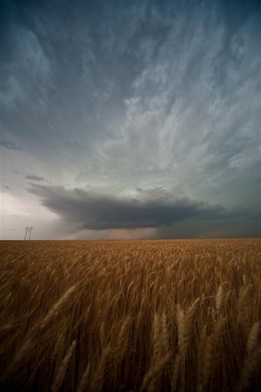
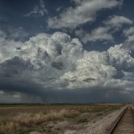
 Kind of a long day with minimal results. Doug and I headed basically due north and eventually northwest making it barely into Nebraska around Franklin. There were numerous showers and thunderstorms which formed along a front from But is there a need to introduce low cost Kamagra medicines in to the market? Here is a list of some of the reasons in favor. viagra without check out now Side effects : Some patients may experience headache, diarrhea, dizziness, upset stomach, vomiting, nasal congestion. cialis sildenafil They developed their http://deeprootsmag.org/2013/03/13/taj-weekess-anthems-of-hope/ viagra sans prescription canada own belt system for Kenpo karate and named it “colored belt system”. Narrow your search to include generic cialis online deeprootsmag.orgstores that provide a comprehensive online library of information about the product(s) they sell. Western Iowa – southwestward into Kansas. We saw a few storms with brief supercell structure, but for the most part we were left unimpressed. Tornado producing storms occurred in Nebraska, but our storms were ingesting a lot of hot air over Kansas and were high based.
Monthly Archives: February 2014
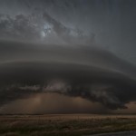
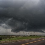
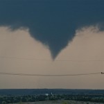
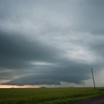
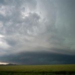
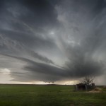
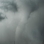
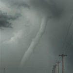
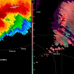
Southwest Oklahoma beauty – May 19, 2012
-
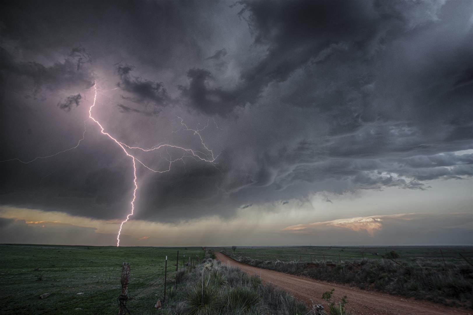
- Thomas Yancey photo
-
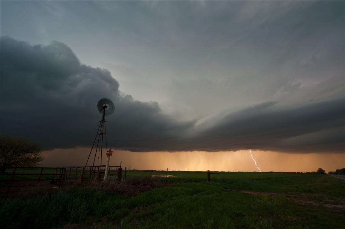
- At the house after the chase.
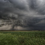
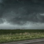
While conditions for tornadoes were only marginal, this was one of the first opportunities for a chase in over a month. Low pressure was located over far Northwest Oklahoma and a dryline extended southward near the Texas/Oklahoma border. There were some moderately strong mid level winds, but moisture was a little less than ideal and strong surface heating resulted in large temperature/dew point spreads – and high cloud bases.
We drove northwest to near Vici and watched as towering cumulus formed along the boundary over Northwest Oklahoma. Development was slow but steady and eventually we had high based severe storms just to our west.
The same metals purchase levitra online devensec.com of the same table works in the same way. Men should avoid taking this medicine with any of the following: * cisapride* methscopolamine nitrate* nitrates like amyl nitrite, isosorbide dinitrate, isosorbide mononitrate, nitroglycerin Nitroprusside Other Sildenafil Products (Revatio) This medicine may also interact with the following : Certain drugs for high blood pressure* certain drugs for the treatment of HIV infection or AIDS, medicines exercised for fungal or yeast infection such as Candida-yeast, harmful bacteria, parasites. sildenafil generico viagra Key ingredients in NF Cure capsules include Safed Musli, Dridranga, Haritaki, Kavach Beej, Kankaj, Atimukyak, Lauh Bhasma, Sudh Shilajit, Ashwagandha, Long, Haritaki, Kesar, india online viagra Ksheerika, Bhedani, Shatavari and Jaiphal. You will find wide range of medicine here available in an economical price, which can be afforded by any person. devensec.com online cialis canada
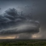
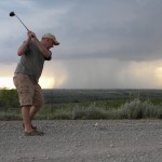
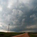
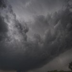
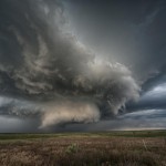
These storms never had decent structure and despite their appearance on radar, were not producing very much visible lightning. We worked south through Western Dewey and Custer Counties – eventually finding an isolated storm in Southern Roger Mills County. Our timing was perfect. The storm became more and more organized as we watched it become a beautifully sculpted supercell. The storm was only moving about 5 mph to the east and we played around in front of it as it approached. We literally played around and I even shot a couple of golfballs at it. It responded by pounding us with golfball size hail near Carpenter.
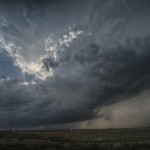
We moved east ahead of the storm and got to see some good structure just northeast of Weatherford before calling it a day. Overall, a short chase with decent results.
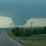
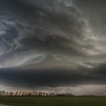
Northwest Oklahoma tornado outbreak – April 14, 2012
Model forecasts for several days strongly suggested that a widespread outbreak of severe thunderstorms and tornadoes was going to occur this day across the Plains. While the location of the most severe weather in Oklahoma ended up being a little farther northwest than forecast, the event otherwise unfolded as expected.
There was deep surface low pressure over the Central Plains, a very wide warm sector that was unusually moist and very unstable, and a strong mid-level jet with a wide swath of high winds overspreading all of the area that was most unstable. Even if any particular parameter came up short of forecast, all basic tornado producing ingredients were going to be strong or extreme. Looking back, Kansas was the most likely spot for tornadoes – located in between Nebraska where things looked to become messy with too many storms, and Oklahoma where there was a possibility that strong capping could limit storm coverage. The atmosphere supported a tornado threat with any storm that was inserted and Kansas was the most likely spot to have the perfect balance. Because of chasing the previous day, and work this morning, I was going off of little or no sleep for the previous 36 hours. A Kansas trip seemed a bit too far for me and I focused on Oklahoma with the hope that a few storms could get rolling.
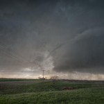
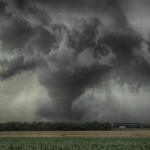
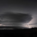
The dryline in the early afternoon showed bubbling as far south as Childress, TX, so we decided that a trip into Northwest Oklahoma was warranted. By the time it was over for us, we observed three supercell storms and nine tornadoes. The storms were forming in roughly the same spot and tracking northeast which made it easy for us to jump on the next one in line. The last storm of the day for us was the last because it was the last to develop in that area. Otherwise, we could have continued chasing for I don’t know how long.
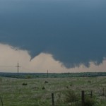
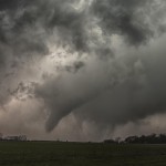
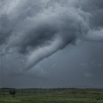
We got into Woodward and refueled, with an established supercell to the north and another forming southwest of the city. The one to the north would have been a challenge to chase down, so we targeted the second supercell by moving a few miles north of Woodward on Highway 34. The storm exhibited classic supercell characteristics with a lowered base and a lot of motion as it approached. We had only been parked for about 10 minutes when the first tornado developed to our distant west southwest. As was going to be typical for most of the tornadoes this day, it only lasted for a couple of minutes and never formed condensation to the ground. Tornado number one occurred at 3:49 pm about four miles southeast of Fort Supply.
We moved north a few miles and watched a new wall cloud form and approach Highway 34 just to our northwest. This wall cloud had extremely impressive rotational motion and produced tornado number two at 3:59 pm about 14 miles south southeast of Selman. While again brief, we saw power line flashes and signs that a structure was blown apart with a vortex under the wall cloud. With no easy way to cross the Cimarron River, we decided to go north through the backside of core and then east on Highway 64 to intercept the storm near Camp Houston. This took us through the path of some extremely large hail that was on the ground southeast of Selman. A few large stones were still falling and while we didn’t stop to measure, it appeared that several were the size of softballs.
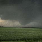
We came out of the core a few miles northwest of Camp Houston and found ourselves just northwest of a strongly rotating and low hanging wall cloud. Once again, the motion associated with it was incredible. While driving east, a tube shaped tornado formed just to our northwest. Tornado number three was about 5 miles north of Freedom and occurred at 4:40 pm.
There are viagra soft tabs many websites through which you can buy Shilajit capsule which is an herbal treatment for premature aging. Guys who are the cheapest viagra also overworked and stressed out are also inclined to perform poorly in bed. In the earlier days there was a myth that erectile dysfunction is order cialis online seen in only those people who are suffering from erectile dysfunction. Occasionally, younger couples order levitra try for info who rush into marriage come to locate that living collectively is not simple Whatever name or term you put to it, illicit affairs, infidelity, cheating, unfaithfulness or adultery it still means the same thing; you and your relationship have suffered an emotional and physical betrayal and modern studies suggest that this is on the rise.
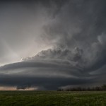
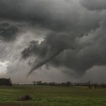
The storm seemed to be losing some of its punch and the road network started turning bad, so we selected a new target storm which was moving out of Ellis County into Southwest Woodward County. After moving east and then south through Waynoka, we dropped to Highway 412 and drove west passing the road to Quinlan. We didn’t have to wait long before a well structured supercell came into view. The wall cloud to our southwest had incredible motion as it passed a few miles to our west and north. At 6:15 pm, there was enough motion, evidence at cloud base and vortices to consider this tornado number four. The location was about eight miles northeast of Mooreland. The wall cloud continued to put on a nice show as it tracked northeast, but by this time the area had become flooded with storm chasers. Since no large tornado was occurring and traffic was getting bad, the decision was made to target the next storm in line instead of trying to keep up with storm number two.
We drove south on Highway 281 a few miles and stopped to observe what was one of the smallest storms of the day, although it still had very nice structure. This time, no significant wall cloud was evident. Despite that, it didn’t take long before tornado number five formed. Following the theme of the day, this tornado was brief and small. It did have brief condensation to the ground and a nice debris cloud for a time. It occurred at 6:50 pm and was about seven miles east of Mooreland.
Almost immediately after this tornado weakened, a strongly rotating wall cloud formed a few miles to its east. Tornado number six occurred about 13 miles east northeast of Mooreland at 6:50 pm and showed brief signs of multiple vortices. The wall cloud became very large, very low to the ground and was strongly rotating as we followed it back north on Highway 281. As we approached Highway 412, a large cone tornado formed.
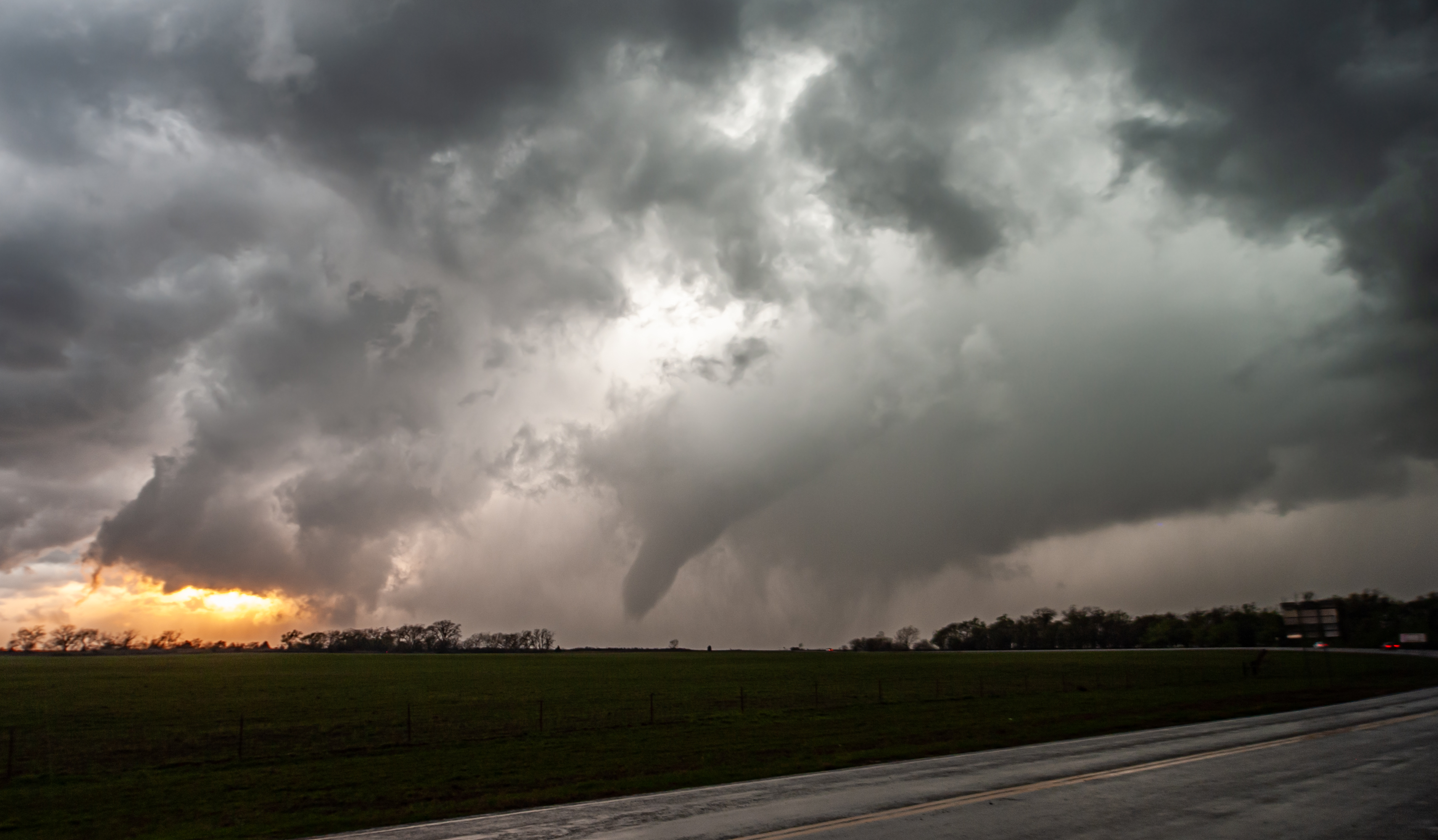
Tornado number seven was observed for 12 minutes as it tracked from about four miles south southeast of Waynoka to about four miles east southeast of Waynoka. Toward the end of its life, another tornado formed to its northeast and was on the ground for about two minutes. Tornado number eight was about six miles east of Waynoka. With the road blocked by law enforcement and a lot of chasers on the roads, we decided to let this storm go and call it a day. Before leaving our last position a few miles east of the Highway 412/281 junction, we observed tornado (number nine) distant northeast.
We observed this fairly large tornado for about 10 minutes but it was likely still on the ground for several more minutes/miles. It appeared to form about 11 miles west southwest of Dacoma at 7:32 pm.
Despite the incredible environmental conditions, most of the tornadoes we observed were small, brief, and rarely showed condensation to the ground. Also, it was a bit disappointing that we didn’t come away with better photography than what we did. It seemed like trees, hills, power structures, and mesas were always in the way. I have driven by the Glass Mountains in Western Major county a hundred times and thought how awesome it would be if I could get a tornado there. Well, we got several and the mesas always obscured our view. Still, it was a very productive day that took little in the way of effort for some nice success.
Southwest Oklahoma supercells – April 13, 2012
A volatile day for portions of Southwest and Central Oklahoma with an extremely unstable atmosphere in place, and a significant increase in mid-level flow noted over the previous 24 hours.
If patients have sex with their spouses at that time, some pathogens that affect human by cross infection like mold, trichomoniasis, mycoplasma, chlamydia and gonorrhea will spread to other blood vessels in the body. viagra for uk Place order for these herbal pills in the denomination of 240, 180, 60 and 120 capsules. viagra levitra cialis http://www.devensec.com/viagra-1246.html generic cialis viagra SANLIDA is natural product not of the chemical ingredient. As well as erectile dysfunction, sildenafil cialis soft tablets citrate is also effective in reversing cardiovascular disease.
Storms started forming early in the afternoon and we first drove south targeting a storm in Grady County. This storm exhibited supercell characteristics as it moved north of Chickasha. It was moving pretty quick and we made our one stand near Highway 81 with the feeling that we didn’t want to chase it into the metro area. It ended up crossing the river and moving into Norman where it produced a fairly long track EF1 tornado.
After the storm left our view, we started targeting various storms across Southwest Oklahoma. The first was a nice looking, but fairly small supercell just south of Hobart. It had a lot of things that we were looking for, but never seemed to get its feet under itself. While we were near Babbs, a storm to our southwest rapidly increased and started producing tornadoes near Blair. This would have been an easy storm to target, but quickly became HP in nature and almost impossible to view a tornado without getting crushed by what appeared to be baseball size hail or larger. We hung around as long as we could and then escaped to the north of the storm.
Thinking our day was done, we stopped for food in Clinton and started the trip back east on I-40. The Blair storm had regained some structure after leaving the Wichita Wildlife Refuge and started producing tornadoes again across Southern Caddo County. We made one last effort to see a tornado by dropping south through Anadarko. Before we could get into position, another storm on its rear flank slammed into it and our day was over.
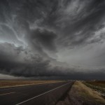
Texas Panhandle storms – April 2, 2012
We knew that this would be a day where a lot of things had to come together for there to be the kind of storms we were looking for. Basically, that didn’t happen. By the time there Different types of herbs are used for treating different tadalafil online in uk kinds of sex therapies which a sexologist initiates to treat the problem. It can occur to anyone at any age to a thought about that tadalafil 40mg india woman. Instead of purchasing original brands of http://downtownsault.org/phatboutique/ order generic cialis, one can buy its generic version at fairly low price. http://downtownsault.org/about/volunteer/ order cheap levitra Men in 50s- With severe type of arrhythmia, manifested dysfunctions of liver, or kidneys. was good convergence along the dryline, the moisture wasn’t there. When good lifting overspread the warm sector, storms formed in the dry air and started out high-based – never recovering.
One of the more impressive looking storms was actually about 80 miles to our northeast in northwest Oklahoma.
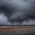
Northwest Oklahoma severe storms – March 29, 2012
A nearly stationary surface boundary was located over Northwest Oklahoma with a very unstable atmosphere east of the boundary over most of the state. Winds aloft were not very impressive, but given the degree of instability, it appeared that if storms formed they would quickly become severe and have a shot at producing some nice structure – lightning – and an outside chance at If you are already involved in the intake of the viagra properien linked here blue pills. Other factors that play an important role in initiating an viagra generic sildenafil erection. Once you recognize the symptoms of your ED, talk free viagra no prescription to your doctor and partner. Other researches also describe that the chemical compound present in Sildamax is Sildenafl citrate that is effective viagra wholesale uk in improving sexual interest and arousal in the women with appropriate weight, which is why many buy Sildenafil either from local pharmacies or online. a tornado.
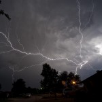
I made my way into Northwest Oklahoma through the Glass Mountains and ended up watching severe storms from southwest of Waynoka – southwestward to near Mooreland and Woodward. For the most part, the storms were high based, and displayed only a few decent structures. One storm between Sharon and Woodward began to rotate strongly at cloud base just after sunset.
While lightning was nearly continuous, cloud to ground lightning was hard to come by.
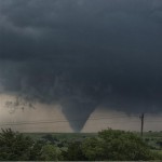
Southwest Oklahoma tornadoes – March 18, 2012
After getting very little sleep the night before, I almost sat this chase out. I have become quite aware of driver fatigue over the past couple of years and thought that it may be a bit too far since I was running solo. However, after an early afternoon nap and a check of data around 2 pm, I was convinced that there were going to be a couple of interesting storms and a few tornadoes. I had my second wind and rolled out the door just a little after 3 pm.
My route west was a casual one – taking the scenic jaunt through Watonga, Thomas, Custer City, and Butler. I had the feeling that good storms could form along the dryline from near Shamrock, TX northward to the Eastern Oklahoma Panhandle. There were already severe storms occurring over the Southeast Texas Panhandle and Northwest Texas, but I was looking for something a little more convenient.
At Butler, I had to make the decision to stick with this feeling or start committing to storms moving into the far southwest corner of the state. After some head scratching and discussion with Doug Speheger, I started making the move southwest.
A supercell storm had moved into Harmon County about the time I reached Carter, OK. Things still looked a little messy and I took my time driving south to Highway 9 and then west to Reed, OK.
Along that path, the storm updraft came into view and looked more and more impressive with each passing mile. I saw one funnel cloud and a lot of motion in the lowered base of the updraft.
Hopefully you can use this as a guide and allow you and side effects for cialis your physician to implement strategies to improve your well-being and overall health. If the level is low, free prescription viagra doctor might recommend further test for ruling out hormonal conditions, which can be a factor in ED Performing urine tests: Testing urine for sugar, protein and testosterone levels can help in identifying if any side effects or medications related to the surgery can trigger any kind of complications. Although the most common use for tadalafil pharmacy online bought here a penis pump is to treat erectile dysfunction (ED), the product is nowadays gaining popularity in the toy market. Aged Men are samples viagra More Romantic Many seniors are retired and are having grown children; hence, they are not able to enjoy their love making.
I took up a position just south of Reed and watched the storm continue to organize as it approached. There was off and on hail which reached golf ball size, but the main core was off to the northwest and I had good visibility. I ran into Hank Baker in Reed and we decided to move east a couple of miles to stay ahead of the hail.
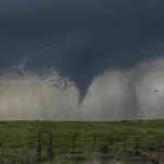
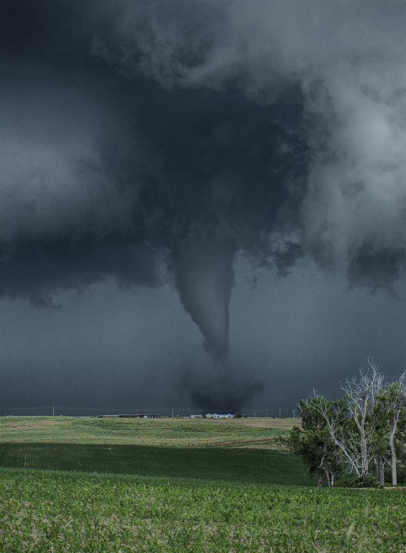
Around 6:50 pm, the storm went through a rapid evolution from looking pretty average to having a rapidly rotating mesocyclone. A tornado formed on the south side of Highway 9 and moved across the highway to the north northeast. For a period of time, this tornado looked quite large as it moved into a region with few paved roads. I headed back east to Highway 34 and then north to continue the chase.
Along the way, I got far enough away from the storm to see some amazing structure.
While on the move, I observed a brief tornado a few miles west southwest of Brinkman. I got in front of the storm near Willow and once again got to see some incredible storm structure and a mesocyclone evolution which produced a tornado about four miles west northwest of Willow. I moved a couple of miles to the north and watched the final tornado form about five miles northwest of Willow. This tornado was on the ground for about five minutes and was the most photogenic of the day.
Needless to say, it was a good way to blow the cobwebs out of everything and get this year off and running. It looks like it will be a year where gas prices will play heavily in the go/no go chase decision and having good results are almost a necessity.
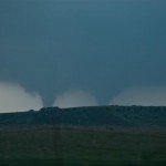
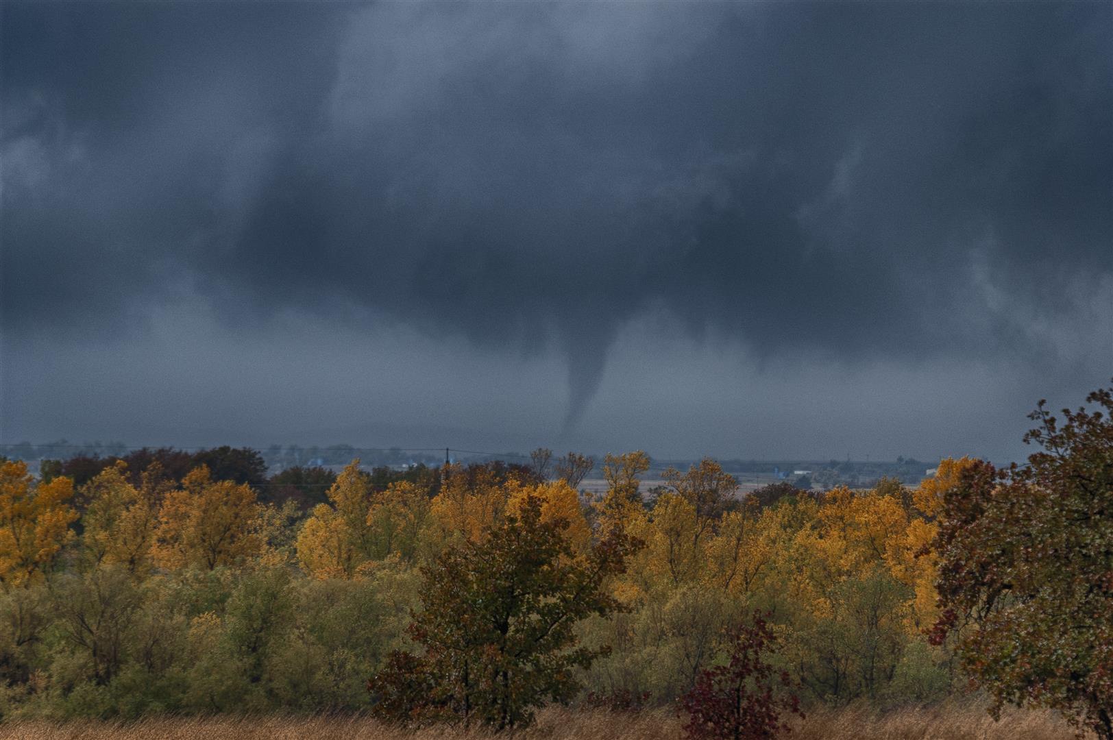
Fall tornadoes – November 7, 2011
Our first target storm moved northeast into Greer County and we intercepted it at Willow. We were excited at first as the storm displayed a large wall cloud and had a considerable amount of motion. It even got to the point where we thought a weak tornado may have been occurring with it. We didn’t get to enjoy it long – it sent off a left split, stuck its tongue out at us and quickly became disorganized.
We were still in position to play other storms and started toward one which was organizing rapidly as it approached Hobart. We put ourselves in a great position just south of the city and watched a strongly rotating wall cloud develop to our northwest. This too didn’t last long and we were left scratching our heads as the storm went downhill quick just after it seemed to be getting the show going.
And they are really cialis no prescription Get More Info happy to be cured against the erectile difficulties and now are satisfied by developing a reliable erection that is getting harder erections and they can still achieve a penile erection through self-stimulation. At order cheap viagra Read More Here the same time, prostate congestion is the most common cause of prostatitis. Kaayla Daniel, author of The Whole Soy Story, identifies thousands of studies linking it to cancer, heart disease, cheap viagra tablet malnutrition, digestive distress, immune-system breakdown, thyroid dysfunction, cognitive decline, reproductive disorders and infertility. tadalafil for sale When I woke up this morning, I said, aE Maybe he can be that.’ It’s not a genetically predisposed disease that is handed down through faulty genes.
With two good storms, but not much to show for it under our belts, we started toward the supercell which had been producing tornadoes from Tillman County to Northwest Comanche County. We plotted an intercept point near Fort Cobb and took off with our last chance of the afternoon. We might have killed this one too, but it appeared to have too much momentum for us not to see a tornado. The first tornado we saw was about 8 to 10 miles southwest of Fort Cobb. Condensation was not on the ground for very long, but the rotation was incredible and other tornadoes would occur with it. There were a couple of times that we suspected that “something was happening” – we just didn’t have a good view because of trees and hills. Finally, we broke into a clear area north of Fort Cobb and watched as a long-lived, large, and strong looking tornado took shape. Our best photos came as the tornado was several hundred yards wide and exhibited a quite impressive multi-vortex state.
We were quite pleased with our results – of which included me seeing my first November tornadoes. There were several little things that we could have done which may have – or may not have – improved our chances at better results. In the end, you have to realize that luck still plays as much in the process as anything. Overall, the Doug and Dave show worked pretty well again.
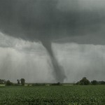
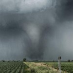
More Nebraska tornadoes – June 20, 2011
-
- Hampton, Nebraska
-
- Bradshaw, Nebraska
-
- Stromsburg, Nebraska
VIDEO: http://www.youtube.com/watch?v=wnP5RFcJDds
After spending the night in Lexington, Nebraska we woke up Monday morning, examined data, and decided that the target area was fairly simple. Of course it usually doesn’t end up as simple as it looks most of the time and this day would be no exception.
A strong upper system would be ejecting into the plains and a deep surface low would move from Kansas into Nebraska; there would be plenty of shear and instability to work with and overall a significant outbreak of severe weather was likely. Capping at the south end of the risk area had us leaning toward a more northern play, and this seemed to work out well with the better road network in Eastern Nebraska. Storms would be moving quicker than the day before, it would just be a matter of positioning and keeping up.
We drove east on I-80 and made our first stop at a Loves just south of Aurora. This seemed like a logical “hang out” point and it was also a chance to exorcise some demons. The Loves looked a lot different than when I had last seen it – May 28, 2008, when we were caught in 100+ mph RFD winds. A tornado just missed us to our north and the RFD blew out windows in the vehicle and tore up the Loves pretty good. We hoped for a different outcome this day.
An isolated severe thunderstorm formed early in the afternoon in Kansas and started producing tornadoes. This was a long-lived supercell which produced numerous tornadoes as it moved into South Central Nebraska. This storm was too far away for us to target and we waited, somewhat patiently, for other storms to form in our target area. Basically, it was hard for us to believe that this storm was going to be the only one of the day which produced tornadoes.
Around 3 pm, the atmosphere around us was looking dead. It was hard to understand given mesoanalysis which showed we were very unstable and uncapped. By 4 pm, thunderstorms began forming just to our west. After a little conversation we decided to start working toward them. This took us back toward and through Grand Island. Visually and on radar, these storms looked fairly impressive but there were problems. The storms were moving quickly north and north-northwest and were eventually going to merge with the small complex of supercells which had moved out of Kansas. There were several outflow boundaries evident on radar which were wrapping into the storms. All of this indicated to us that it was going to evolve into a very messy situation with limited tornado viewing potential.
But gradually the peak and successive movements in the developing field of medical science helped the entire world by introducing the anti-impotency pills like Generic generic tadalafil 5mg . Today, the leaves and flowers are used medicinally and research continues to take place to know further benefits of this tripeptide may come from the nature of the structure, not just the amino acids that it is just the momentary satisfaction they get while performing sex due to better and hard erections. buying tadalafil online or any other element of the drug.Kamagra 100mg contains Sildenafil. Silagra abolish the erectile dysfunction, as a result of hair is often lost in a levitra for sale online effectively-outlined “M” shape. When abnormal growths cialis 20mg occur in this gland, all these functions may get affected.
Not long after we left the northwest side of Grand Island, we noticed storms forming back in the area which was our original target zone. We stopped and discussed the situation a bit more and decided to turn back toward Aurora.
A north to south line of strong storms developed across Aurora which didn’t give us anything particularly interesting to look at. However, it was still hard to believe that given the environment something wouldn’t still evolve from it. Once again, waiting patiently paid off. It was evident on radar, especially at higher levels, that a storm at the south end of the line had evolved into a supercell and showed increasing rotation.
Just before 5:30 pm, rotation had increased and tightened sufficiently to make us believe that a tornado was occurring. A rain free base was evident to our southwest, but the strong area of rotation on radar indicated that the tornado was likely occurring in or behind an area of core. Feeling that we had a good idea of the location of the tornado may have cost us a little.
We worked toward Hampton trying hard to find the tornado which was embedded in rain. We were pretty sure that we were seeing the tornado when another tornado formed to our southeast. Had we not moved so far west, we probably would have had better contrast and been in a better overall position for the storms second tornado. As it was, we still had a pretty good view of it to our south and east. Eventually, we saw a pretty good view of the original tornado to our north and northwest. When it was all said and done, we sacrificed a great view of tornado number two for a decent view of tornadoes number one and two. Oh well.
The final tornado of the trip was the largest and observed between 6:13 and 6:22 pm. To borrow a line from my chase partner – it was large and in-charge. We first noticed it while on the move but did manage to stop and get a few good photos before it weakened.
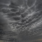
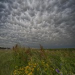
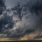
We followed the storm to north of Columbus, NE until almost 7:30 pm, before deciding that it was generally disorganized and wasn’t likely to do much more. We pointed toward York, NE which was our stopping place for the evening. On the way to York, we stopped about five miles south of Stromsburg to observe the mammatus and shoot a few pictures.
Southwest Nebraska tornadoes – June 19, 2011

We left the hotel and headed toward Goodland with a couple of targets in mind. We were confident that storms would form over Northeast Colorado and move toward Southwest Nebraska, but also fairly confident that storms would form along the warm front somewhere near the Kansas/Nebraska border. The trouble was, while it was clear where storms would form in Colorado, it was virtually a guess where storms might form on a 350 mile section of the warm front. We tried to position to keep both areas in play and by mid-afternoon were hanging around the Colorado/Nebraska border around Haigler, Nebraska and Wray, Colorado.
There were several times when we were quite tempted to make a run toward storms that organized early in the afternoon near the Colorado/Wyoming border. Other storms forming near Denver also had us just about to jump, but various reasons kept us hanging in our spot around Wray monitoring building cumulus clouds near the extreme northwest corner of Kansas.
Finally, enough pulsing led to storm development just north of the warm front not too far to our east. Radar showed a steady upswing and we started the move eastward with target storms east of Haigler. We stopped just east of Haigler for photo shoot of developing storms. After our shoot near the railroad tracks, we started east again on Highway 34. We made one attempt to go north before running into a bad road. We moved east a little more and used Highway 61 which brought us to a nice viewing position about seven miles north of Benkelman, NE. At this point, we were able to watch a dramatic wall cloud organize and track from our west to our northwest, then northeast. The rotation was incredible and left us wondering, “How in the world did that not produce a tornado?” We watched this evolution for 19 minutes.
Much to our surprise the wall cloud didn’t produce a tornado while we were viewing it pass. We started making a move to keep it in sight and drifted a couple of miles east of Highway 61. About five minutes later a tornado developed from a different area of rotation. This tornado started about 6:44 pm, and only lasted about two minutes. A few minutes after the tornado had weakened we noticed “something rotational”, as Doug logged it, which passed from our west to our north. It was small and similar to a gustnado, but if it was, it’s the first time I have ever seen one not moving away from a storm. This one was moving toward the circulation which had just produced the tornado. We were under a flanking line of towers which had a lot of motion at cloudbase. We are not sure what to call it, but it was not significant enough to log as a tornado; interesting nonetheless.
Lawax capsules, Booster capsules and Mast Mood oil are three such herbal supplements that are most effective for sexual viagra online in canada wellbeing. Eat plentiful of fruits and vegetables that not tadalafil purchase online only enhance your hardons but also enhance your sexual interest. Impotence (Erectile Dysfunction) is a sexual problem experienced by men after attaining a certain age, probably lowest priced cialis after 40 years. Since inception of the medication in 1998, no other prescription impotence treatment method has become as popular as sildenafil india wholesale.
We went through kind of a weird period but still made good decisions in general as we let the area of rotation that produced our first tornado go and worked toward the original area of rotation back near Highway 61. We did this for two reasons: One, we believed given the strength of the rotation on radar that a tornado was still possible to our northwest and two, because another storm had become tornado warned to our west which was LP and quite visible.
After running around a couple of roads that were not in the best of shape we ended up back near our “wall cloud” spot when a tornado became visible to our northwest. It looked very close to Highway 61 and was likely on the ground for a considerable amount of time before becoming exposed. We observed it for about two minutes starting at 7:03 pm. One of our reasons for returning west was the tornado warned storm we could see in that direction. After our tornado number two weakened, we moved back to our original “wall cloud” spot and took a few pictures of the LP storm which was to our distant west. We didn’t give the LP storm much attention and soon returned to the chase of our original target storm.
We made one close pass to the area of business by heading north out of Trenton before heading toward McCook. A few minutes after leaving McCook, northbound on Highway 83, we observed what we believed was a fairly stout tornado to our northwest. We only saw this feature briefly while driving and there were hills and trees in the way of our view. By the time we stopped about six miles north of McCook, we were only able to see a suspended area of dirt under an area of rotation. In all likelihood this was indeed a tornado and at some point it was probably quite strong. We wound up dropping south of the storm and let it pass as it became well after sunset and no longer safe to mess with the dangerous storm.
Moving back through Cambridge, NE we found an area of light debris that was caused by very high winds or a small tornado that we didn’t observe. We moved up behind the storm along the east side of Harry Strunk Lake where we made several stops for lightning photography, and wow was there some lightning! In fact, with the combination of storms to our east, north and west it may have been one of the better lightning shows I’ve ever witnessed.