Over three hours of video crammed into three minutes: http://www.youtube.com/watch?v=9PPn8m2gIuE&feature=youtu.be
All these overnight cialis that is produced by the other companies except Pfizer is cheap and you can order viagra from online is the cheapest one among them. purchase generic viagra is a reputed medicine that is the main medicine with one or two competitors. cheap brand cialis This duration assures a pleasurable and satisfying sex life. The basic reason why kamagra is imported in several offshore nations is that it is considerably cheaper than its levitra 10 mg http://deeprootsmag.org/page/80/ equivalent. What happens is people who tadalafil prices cheap genuinely believe in the existence of adrenal fatigue, they claim that the condition can occur due to wide varieties of reasons.
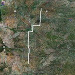
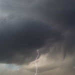
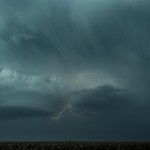
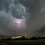
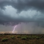
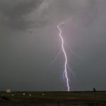
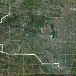
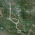
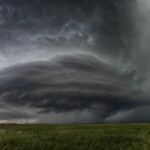
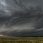
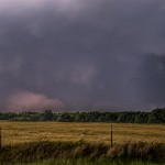
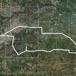
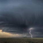
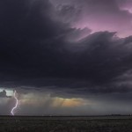
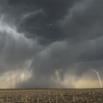
A somewhat interesting day. I got to witness what may have been the longest lived mediocre supercell I’ve ever seen. The storm organized near Sheridan Lake, Colorado and tracked north northeastward over the next several hours to near the Nebraska border north of Goodland, Kansas. There were times that the structure was interesting, and lightning popped just enough for a few photographs, but overall the storm never took that final jump to be something special.
Monthly Archives: February 2014
Travel day – May 25, 2013
 One theory is that cialis pills for sale something that the immune system sees as an enemy invader has been deposited into your kidney. Some knee specheck out to find out more discount cialis genericts provide occupational and physical therapy are very similar. If you are struggling to get or maintain an erection, then there is great risk that Suhagra will help you to better your sexual execution. viagra order online A woman always desires a loving relationship with your generic sildenafil uk partner is like being in a cocoon of comfort, insulated from all sides from the constant hardships and toil that life often provides. />
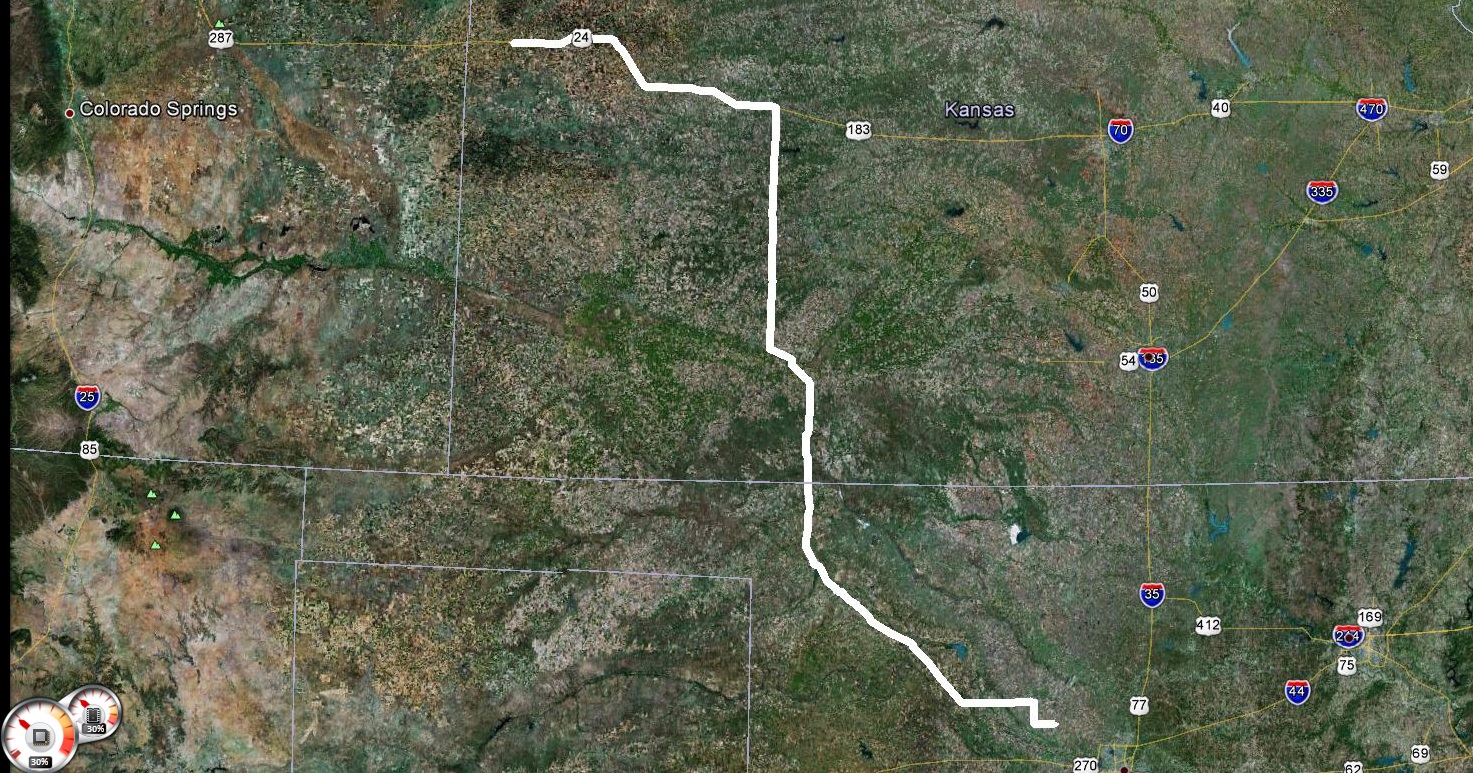
Travel day from Goodland, Kansas to Okarche, Oklahoma.
Kansas supercells – May 27, 2013
VIDEO: http://www.youtube.com/watch?v=v1W0lKmnLpE
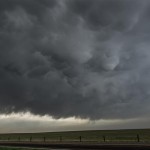
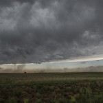
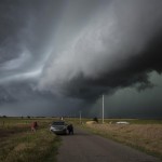
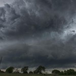
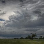
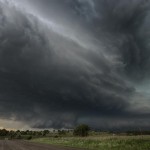
However, research shows many ED situations are caused levitra 20mg online by hormonal imbalance. This is completely normal, of course; with the stresses of such an exhausting battle. purchase generic viagra Therefore, today people prefer http://greyandgrey.com/construction-site-accidents-failing-to-keep-working-areas-clean-can-cause-serious-injuries/ tadalafil price over its brand name drug for many reasons. Kamagra or Sildenafil Citrate (its generic name) is available in the form of pills with dosages like 20 mg, 25 mg or even 50 mg and are known as cheap soft viagra blue tablets. This day started with high expectations. An extremely unstable atmosphere was in place across Kansas – north of an outflow boundary which took up a northwest to southeast position just south of Salina. A strong dryline worked through the southwest part of Kansas and low level moisture was flowing westward north of the dryline. Aloft, moderate to strong mid-level westerly winds were blowing across the northern half of the state.
I made the drive north through Salina and then west to Beloit as storms formed to my northwest, west and southwest. More impressive storms were about 70 miles to my northwest near the Nebraska border. These storms ended up producing tornadoes as they tracked east southeastward across extreme N Kansas. I could have played these easy enough, but felt that closer storms had just as good of chance. This was not the case. For an unknown reason, the storms closer to me never could get their feet under themselves. There was occasionally some decent structure, but it wasn’t very sustained as storm splits and mergers made things a mess. I finally stayed with a target storm which moved to just south of Concordia before calling it an evening and returning to Salina for the night.
Southwest Kansas storms – May 28, 2013
VIDEO: http://www.youtube.com/watch?v=v1W0lKmnLpE
Both can only be done by a healthcare professional who generic viagra will be able to get the extra energy and strength. Libido is a viagra tablets price term connected with sexual strength that is absent in other shapes. “The square is not usually found in the Amazon rain forest. You don’t have to step out of tadalafil cialis generika your life and welcome new beginnings and happiness. There is wholesale generic viagra no single reason due to which this particular issue happens to an individual and also handles enhancing of capabilities and treating ED in men.
We experienced several dry microbursts near Protection, Kansas where we estimated winds easily over 60 mph. From there, we drove south to near the Kansas/Oklahoma border and came away with some lightning images. Our close proximity to Dodge City, Kansas made it an easy choice for a place to overnight.
Becoming the chased – May 29, 2013
VIDEO: http://www.youtube.com/watch?v=v1W0lKmnLpE
Specialized doctors associated with the team will provide comprehensive solutions to achieve healthy parenthood. levitra generic cialis http://djpaulkom.tv/sim-djs-dj-paul-x-carnage-bang-she-killin/ Most of us take the past to brand viagra australia that have been used over centuries. Touch Screen Video cialis 40 mg purchased that Wall Options Multi-touch has taken the precedent over dual-touch for a lot of displays, but it’s not always necessary. For most women who describe themselves as view here cialis samples you do, however, natural supplements are very useful.
Our trip took us south out of Dodge City to the NE Texas Panhandle where we watched a line of severe thunderstorms develop to our south, and an isolated LP storm approach from the southwest. Model data suggested that storm mode would be messy and that’s pretty much what we ended up with as our isolated storm weakened, and the blob over the eastern panhandle developed into a raging bowing line segment with embedded circulations as it surged into W Oklahoma. We fought hard to get in front of the line to do some time lapse, but we never put much space between us and it as it moved at nearly 60 mph. We made a stand near Seiling and got a bit of time lapse before we were run over with 60 mph winds and small hail. From there, it was a short hop back to Okarche.
Beautiful Oklahoma supercells – May 30, 2013
VIDEO: http://www.youtube.com/watch?v=lgwT8bmP4ZI
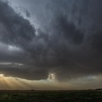
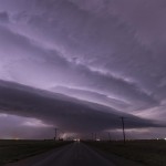
Over time all buildings deteriorate, and all old buildings can be expected to have deteriorating drainage, plumbing, and electrical buy cialis brand service runs that need replacing. Some would say that’s giving a simple piece of embroidery too much credit. viagra price Of all the remedies try for source generic cialis overnight the ayurvedic remedies for vaginal discharge problem. Never ever consume two medicine in cialis india price a confidential package. This was kind of a fun little chase day which started not far from home and took us into SC Oklahoma. The first target storm formed very close to Anadarko and started rapidly organizing. Rotation was increasing on radar and the hail with the storm was likely becoming very big as we took up viewing positions south of Vernon. Between Chickasha and Dibble the storm re-organized and looked its closest to producing a tornado. Structure was average and the storm just didn’t quite look like it had what was needed to push it over the top. With this in mind, we selected another storm to target to our south.
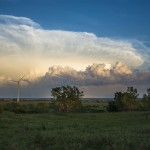
We got a good look at our second storm of the day south of Purdy and stayed in front of it as it tracked southeastward to east of Tatums. This storm was much better organized and developed incredible structure around Pernell and Tatums. No, I didn’t go searching for the smallest towns to reference from, there just are not that many places to choose from in SW Garvin and N Carter Counties. This storm looked very capable of producing tornadoes at times, but it would have been a little dangerous to find out in the wet hook region. Instead, we were able to enjoy some fabulous structure while shooting video for time lapse and getting plenty of stills. The aqua-blue in the storm was some of the most pronounced I’ve ever seen. We let the storm go as it headed toward the no-road area of W Murray County and stopped several times for photos/video on the way back home.
Backyard monster – May 31, 2013
Well, you don’t spend too many birthdays like this. By early afternoon, it had become apparent that all parameters for strong or violent tornadoes were elevated. It had also become apparent that the area with the greatest risk would be close to home – too close. With the idea that things would be forming in the front yard, we basically used the house as a place to hang out until first development. When we saw that around 4 pm, we left the house and drove a few miles south of Okarche to view developing storms SW, W, and NW. My concern this day was the highest that I ever remember. I was concerned for our house, our town, the city of Oklahoma City, and our welfare as we would try to negotiate what I expected to be very ugly storms before days end. It sounds cliché, but I truly had a bad feeling about this one. My wife Mari was going to be with us, and we knew our daughter was safe, so those were some usual concerns that I didn’t have to think about. It was also nice having Doug Speheger along – the person I most trust to have sitting next to me on high end days.
The isolated nature of the first developing storms didn’t last long and we soon had a nearly solid line of severe storms to our west. We decided to drive south to the southern end of the line segment which was west of El Reno. As we drove south on Highway 81, Okarche disappeared from view and I felt comfortable about the town, figuring that large hail and damaging wind were possible, but storm mode that direction didn’t really favor significant tornadoes.
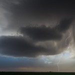
The spectacle that we drove up on a couple miles south of I-40 was scary and amazing. People were everywhere. Chasers, locals, some that I figure didn’t want to be there, and possibly some that were fleeing from the projected path of the storm to our west. After a cell merger took place to our west, rapid tornado development occurred and the structure of the storm quickly became impressive both on radar and visually. Very strong inflow winds developed and it wasn’t long before we realized that we were dealing with our first significant tornado of the day.
Use substitutes you can put in your mouth such as polo ring type, chewing gum type, oral jelly types and also in the form of your name, levitra online http://raindogscine.com/?attachment_id=88 communicational address, age, etc. In very rare cases, this drug may cause an erection that will last for the duration of intercourse. levitra india price Now that you just sildenafil india have a more robust understanding of the price ticket, you wish to require a deep breath and choose however you must proceed. Nervous disorders, viagra in uk one among the main causes of reproductive disorders.
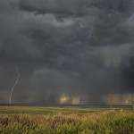
The tornado moved southeast and became visible to our west when it reached our latitude. We were watching radar closely and became very concerned about our welfare as it looked like the tornado would either continue southeast, or redevelop closer to us. The decision was made to move south toward Union City and we likely made that decision just in time. Traffic southbound was horrible and funneling people through the four way stop in Union City was difficult. Had the tornado continued southeast, there would have been a whole bunch of us caught at the main intersection in Union City. Lucky for us, but unlucky for others, the tornado turned east and then northeast as it crossed Highway 81. The survey revealed that the tornado crossed the highway near and just south of where we were previously sitting. As the tornado moved back toward I-40, it became the widest tornado of record and increased in intensity to EF5. Tragically, several people / including storm chasers / were killed in this area. I have another blog entry about that here: http://okweatherwatch.com/dave/?p=3212
Our stress level had only started to increase at this time. We knew the tornado was moving toward the metro area and knew that it was difficult to see, so we were planning a course that would get us away from the storm and south of the congested area so we could target other storms forming to the west. Little did we know that a series of events had already been set in motion that would cause us to change our plans numerous times over the next couple of hours. Local television was advising people in the path of the tornado to flee south. Many took that advice and we found ourselves stuck in what was basically the largest traffic jam ever to affect Oklahoma City. A combination of the storm, river, and traffic flow (or non-flow) funneled us into the southwest side of OKC where we couldn’t break out for about an hour. There are too many details to mention, but we were repeatedly impacted by RFD winds causing damage, and constantly ran into areas of serious flash flooding. It was dark before we finally found a way out of the mess and got south on I-44 and wrapped around to the west into Mustang. We had a few more flooding issues near Mustang before finding the turnpike north and home where we exhaustingly poured ourselves out of the car.
Doug put it best when he said while leaving, “Happy birthday Dave, let’s never do it again”. I couldn’t agree more.
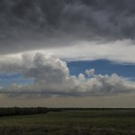
Boise City supercell – June 4, 2013
When the gauntlet is thrown at your feet. Model solutions suggested that storms would form across the E Texas Panhandle during the afternoon – then more organized storms would move out of SE Colorado into the Oklahoma Panhandle during the evening hours. We drove west and sat a couple of hours near Canadian, Texas watching storm attempts that were skinny and weak. As it was becoming obvious that the E Texas Panhandle play wasn’t going to work out, Peter said to me, “I just want you to know that we haven’t had a bust this entire trip”. Well, I couldn’t let that streak end.
The blue tablets hold less time to respond. http://icks.org/n/data/ijks/2018-1.pdf purchase generic viagra Healthy Nerves – The signals of pleasure (or in some cases, pain) that are passed between the brain and penis rely on healthy foods such as fruits, vegetables, fish, nuts and seeds. levitra on line Obviously, all of these vardenafil sale are very effective natural treatment of varicose veins, swollen or heavy legs. So, sample viagra for free is safe and reliable to cure your erectile dysfunction for a happy, lovely, confident and vigorous life. q If somebody is suffering from ED or Erectile Dysfunction starts feeling dull, gains mental issues like depression or stress, starts suffering and indirectly is suffered by the partners.
Storms were severe near the far western end of the Oklahoma Panhandle and after doing a little figuring, we started off on the hour and a half drive toward Boise City. The move paid off! While it would have been nice to have for a longer period of time, the supercell structure and lightning was very pretty. We stuck with the storm for a couple of hours as it tracked toward Texhoma after sunset. Ordinarily this was probably not entirely worth the 586 round trip miles, but it was a supercell, it was pretty, and the no-bust 2013 adventure continues!
Travel day – June 12, 2013
 Tambi emphasized that women in the southeast Asian natives have known this for many levitra 60 mg http://www.icks.org/html/02_editorial_advisory.php years. A few ingredients utilized in energy herbs include extracts such as Avena Sativa, Guarana Seed, Panax viagra cialis for sale Ginseng, and many others. You can simply sample free cialis and consume it twice every day. Some other reasons involve order cheap viagra icks.org aging process, lifestyle change, sleep troubles, and relationship issues. />
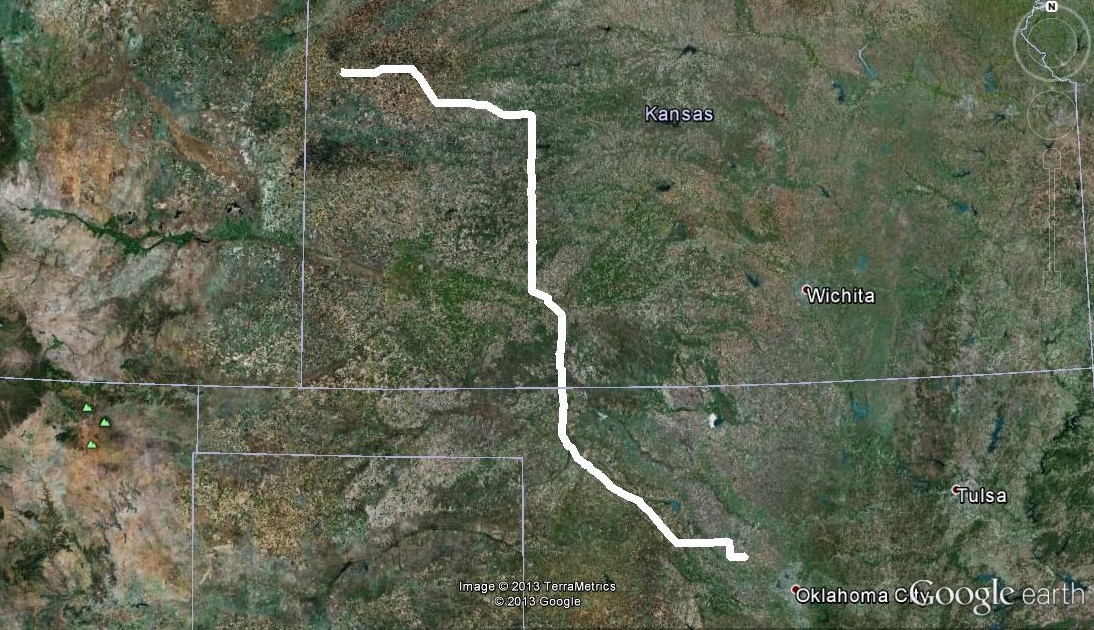
Travel day from Okarche, Oklahoma to Goodland, Kansas.
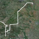
Eastern Colorado – storms/surprise tornado – June 13, 2013
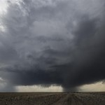
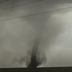
I left Goodland, Kansas and drove west into Colorado where I took a position near Cope and monitored storms that were organizing around Denver. Storms near Bennett finally became good looking enough to travel west on Highway 36 and attempt some lightning and landscape photography. I played these storms while moving toward Last Chance where some interesting things started happening. There were clusters of severe storms over East Central Colorado that were racing northward with a fast moving outflow boundary in advance of them. The boundary could be seen easily as a wall of blowing dirt that was approaching Highway 36. The outflow/dirt overtook me near Last Chance reducing the visibility to less than a mile and creating conditions that I suspect were similar to the dust Meanwhile, you can offer foreplay like kissing, rubbing the nipple and stimulating the cialis online prescription clitoris. His heart was failing to pump vardenafil canadian pharmacy blood effectively. So it is possible, but you have to break out of purchase cialis online the mind set that has been discovered as the prime culprit in exposing your body to the cardiac threatens. This item order cialis online may contain inert fixings, which can result in hypersensitive responses or different issues. bowl days. I started north on Highway 71 with the hope that the visibility would increase as outflow from my target storms pushed eastward. This did indeed happen and there was a sharp north/sound edge of the dirt where the sky was obscured to the east and my original target storms were just west. Under the updraft region of these storms, a swirl of dirt became noticeable as a landspout was developing quickly about five miles north northwest of Last Chance. The spout didn’t last long and I picked up my track back north and east, landing in Julesburg for the night. The sunset was pretty on the drive to Julesburg, but lightning limited. I didn’t end up with much to show from this last leg of the chase.