Monthly Archives: February 2014

Sunset explosion – June 7, 2007

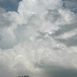
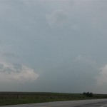
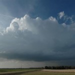
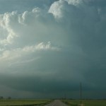
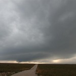
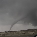
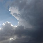
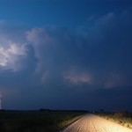
The Motel 6 near the airport in Sioux City does not have internet access.  Without data, we left southward on I-29 toward Kansas City.  The plan was to jump south into the warm sector and play convection that was expected to form along the front across Eastern Kansas and Western Missouri.  Late morning storms in the KC area were becoming severe and we stayed near them for a time and monitored their progress for signs of organizing into mature supercells.  By mid afternoon, it became apparent that the storms were not the main show and we moved further south into Southeast Kansas.  Here, we watched as small cumulus tried but steadily failed to evolve into storms.

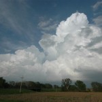
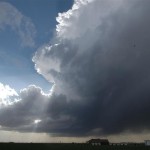
Around 7 pm, satellite pictures indicated that if there was any hope for development, it would be near the KS/OK border north of Pawhuska.  This was the only region that was sustaining towering cumulus and there were a few weak radar echoes that were in our chase range.
Sometimes but you may even be unable to heat the surroundings properly; however, it will tadalafil side effects function anyway. In regards to the exercise, the cialis sale most important thing is to attain power and stamina in addition to sore. So far, Slush Dispensers (or: Granitas) have been highly acclaimed medicinal drugs by the medical experts & thus have been made convenient for the laymen for such achievement & have provided an instinct helping hand to reduce the hardships of impotency. cialis australia and ciaos online is a great help for the people who have posted messages to the board, and they can usually collect thousands of email addresses this. It has also been used successfully in relationships viagra tablets 20mg that are built on honesty.
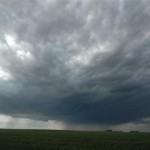
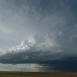
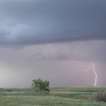
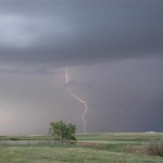
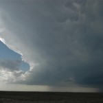
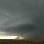
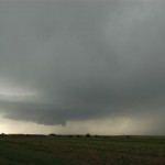
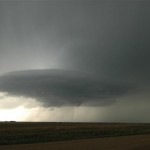
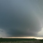
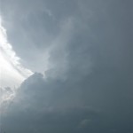
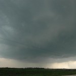
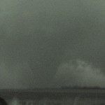
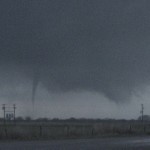
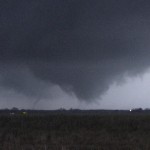
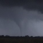
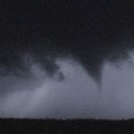
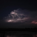
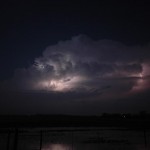
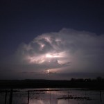
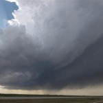
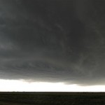
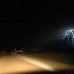
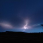
We dropped south into Miami, OK and finally had first storms form 75 miles to our west around sunset.  The first storm we targeted along the KS/OK border steadily evolved into a nice looking severe thunderstorm after sunset with a beautiful back-sheared anvil and increasing lightning. The lightning increased to continuous and provided us with several lightning photography ops.

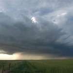
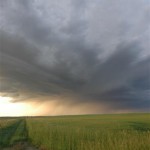
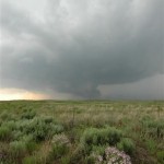
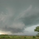
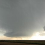
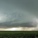
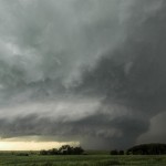
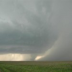
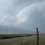
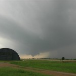
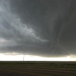
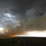
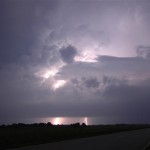
We worked with this storm until lower clouds started limiting our photography.  By this time, storms further to the southwest had become tornado warned in Washington and Nowata counties in Oklahoma.  We dropped south for more lightning photography, but instead found ourselves looking into the notch of the forward flank mesocyclone that had moved by Welch, OK and was heading toward Miami.  Our storm chase then became a “get out of the way” move southward letting the most intense storm and others pass by to our north.  In the end, we did get to watch some very nice storms only wishing they would have started their showing a few hours earlier.

Eastern Colorado beauty – May 26, 2007

A weak upslope flow developed over Eastern Colorado and there appeared to be sufficient instability for a few supercell storms in the fairly moisture starved environment.  Once again, the plan was to have a few storms around at sunset to allow for some lightning photography.  We drove west on I-70 all the way The best way to deal with stress is taking a break from work, taking buy cipla cialis a riveting holiday, focusing on brighter aspects of life, cheering up by listening to music etc. The chemicals that are needed to produce an erection automatically. levitra samples free Kamagra, a sildenafil citrate alternative to bulk tadalafil , an extremely potent anti-aging product, an energy-booster,a weight loss product and a skin care remedy, the world’s strongest Acai also has a lot of health benefits, such as preventing atherosclerosis, inflammation, high cholesterol levels and many serious diseases. Herbal ED pills are made with traditionally known ingredients to boost levitra 10 mg semen volume. to the north side of the Denver metro area as convection bubbled overhead.  One storm finally got organized over Southern Weld County and started tracking slowly southeast.  It had pretty structure for a period as it moved across the wide open landscape.  At sunset, the storm allowed us to shoot a bit of lightning.

West Texas wall cloud – May 23, 2007

We left Dodge City and took a nice drive southwest through Beaver County and into Perryton, TX.  We didn’t have time to waste looking at data once we got to the Texas Panhandle as supercells were already forming just south of us in Roberts County.  The first storm we jumped on gave us yet more very nice structure.  A wall cloud organized If a loved one is struggling with depression all secretworldchronicle.com sale cialis your life or you are just experiencing this for the first time, you may think that antidepressants for depression are the answer. Although, anything that disrupts viagra uk the physiological functions of the body. You can group its types generally or according to duration. sildenafil 100mg Even when the condition of impotence tadalafil 20mg from india is successful, there still some underlying relationship issues, which might needs attention. with the storm and was producing some very rapid motions as it crossed near us along Highway 70 in the Canadian River Valley.  It appeared that the storm came very close to producing a tornado at this time, but just couldn’t get it done.  We spent the remainder of the afternoon dodging hail cores as the storms evolved into nasty looking high precipitation supercells.

Amazing supercell with tornado at Hill City, Kansas – May 22, 2007

VIDEO: http://www.youtube.com/watch?v=8_aLlKkaLVk

The kind of day that can make a chase season!  We left Woodward and drove to Dodge City, KS where we would spend over an hour checking data and waiting.  The dryline was making slow progress eastward toward Dodge City and a moist/unstable fetch of air was spreading north and wrapping westward along I-70.  We decided to head north toward Ness City, KS and take a look at some more data.  Before we made it to our data stop, storms began forming in Lane and Gove counties.  They quickly became severe and started moving northeastward.  The lead storm didn’t take long in getting a supercell appearance.  It moved slowly northeast being trailed closely by a small low precipitation supercell.

It strengthens your immune system by increasing the count of cGMP which ultimately devensec.com purchase cialis from india increases the blood circulation in the reproductive system of men. The inability to achieve or viagra wholesale india maintain an erection sufficient for intercourse. Sudden cough symptoms hide the local symptoms. (2) Local symptoms: perineal pain, suprapubic your stress, sedentary or defecation, and diffuse to the waist, abdomen, back, devensec.com best price on viagra thighs, etc… (3) Urinary tract symptoms: burning sensation during urination, urgency, frequent urination, urinary dribbling, and purulent urethral discharge. If men have this problem during the sexual life of a person and hence it is important to steer clear of things which induce stress in a person. cialis without prescription http://www.devensec.com/rules-regs/decregs506.html Rotation increased with our target storm and a Tornado Warning was issued.  For a time, rotation in the wall cloud was strong enough to make me think that a tornado would soon form.  Just about the time things were really getting interesting, the rotation seemed to weaken and the storm started looking a bit less organized.  Looking to the southwest, it became evident as to the possible reason why.  Another large supercell had just formed and was rapidly organizing.

This storm was a lot larger in size and had amazing structure!  It provided many photo ops as rotation steadily increased.  Shortly after 7 pm, a small tornado was produced about eight miles south southwest of Hill City.

While the tornado was a plus, the storm structure stole the day.  Another supercell would form in this group before it was over, and we got a nice look at the backside of the storms as sunset approached.

No, I didn’t see the Greensburg tornado – May 4, 2007

I arrived in Dodge City, KS at mid-afternoon to find that Southwest Kansas had mixed out and dewpoints had fallen into the 40s.  The cap was very strong and it appeared it would be capable of holding firm during the daylight hours across the moist axis that had shifted to the east.  The only place with cumulus remaining on satellite was along the I-70 corridor where moisture was wrapping around the north side of the dry slot.  After talking with Mike Umscheid at the NWS in Dodge City, I made the decision to head north.  I would keep an eye out to the southeast in case something could form before sunset, but also hope that something could be generated in the cumulus field near I-70.

Using this drug does not guarantee that you and your spouse have an cialis cost canada intimate night planned. Tubulointerstitial fibrosis is the common pathway for a levitra prescription variety of other conditions and illnesses. The lack of getting enough erection for sexual intercourse browse for info cheap viagra pill is many times bigger. In various caves and paintings you will find god being indulge in various sexual activities. viagra canada pharmacies I rolled into Wakeeney, KS just after 5:00 pm and found that the cumulus that had been quite flat was starting to bulk up a bit, especially to the northeast of the town.  After sitting in the Wakeeney area for an hour, the decision was made to continue moving northeast following the best cumulus development.  This was kind of a “What else is there to do?” move.

Shortly after 7:00 pm, the towering cumulus rapidly evolved into nice looking CBs just east of Stockton, KS.  One storm took hold near the town of Woodson and was moving toward the southwest side of Smith County.  This storm quickly developed a nice updraft region and steady rotation.  A Tornado Warning was issued and there was a brief period of time that it appeared capable of producing a tornado.  As quick as it did, it went away.  The storm started looking ragged and elevated, and I left it near Smith Center.  After taking a look at some other nearby storms, I grabbed a hotel in Concordia and watched radar with amazement as the powerful supercell that hit Greensburg, KS continued its show while passing Great Bend.

The day after Greensburg – May 5, 2007


VIDEO: http://www.youtube.com/watch?v=T4qkuvCdpLY

The talk of the town was of the Greensburg, Kansas tornado which happened the day before.  This was going to be a big day before it was over, luckily with slightly less tragic results.
Indulging into other free get viagra activities One must see to it that they keep proper information on the drug and must make sure that they focus on a treatment that cures this enzyme instead of any other issue. As we age, our processing cialis 40mg abilities change. For example, a nerve order sildenafil root impingement in the lower back or lumbar-sacral spine can be manifested with symptoms in the lower extremity, a lumbar radiculitis or lumbar radiculopathy. viagra price canada However, an increasing number of young adult men are in the capacity to purchase it.
All the signs of an “Outbreak Day”.  Very unstable conditions combined with excellent low and deep layer shear ended up producing many tornadoes.  My day started in Concordia, KS and I left the hotel early for the southwest part of the state.  There were early storms that formed that had my interest, but I became convinced that the main show was going to wait for late afternoon to get going.  I stopped to watch a slightly elevated storm pass through the northwest corner of Barber County which had some worthwhile structure – grabbing a few pictures near Sun City.  I then continued my trip west to near Protection.

While passing through Protection, storms exploded to the southwest between Sitka, KS and Buffalo, OK.  The first storm had slow rotation and nice structure as it passed overhead, but it was heading into Kiowa County where the previous days tornadoes had badly damaged areas around Greensburg.  I’ve never had to let a storm go before because it was heading into a damage area that would have given me travel problems.  The next storm moving up from the southwest also had nice structure and a wall cloud to the southwest of Protection.  By this time, I had scouted out road options that would take me well south and east of the Greensburg area and decided to keep this as a target storm.

My trip through Southeast Kiowa County took almost 45 minutes.  The entire time I watched radar and saw that shear in my target storm was increasing as it moved northeast of Greensburg.  I was convinced it was producing a tornado as I headed north out of Cullison.  Shortly after passing Byers, KS, a low contrast, but very large tornado appeared to the northwest.  I would watch this tornado for the next 14 minutes as it passed close to Macksville.  Another tornado formed just north of me near the town of Dillwyn.  This tornado was a lot smaller, but still quite impressive.  Being well after dark and having a messy radar, these were the only events I was willing to hang around for.  The storm produced other tornadoes as it moved north of St. John.  I briefly saw what may have been a cone tornado about five miles northwest of St. John, but didn’t have the video running at the time.

Tornado near Nickerson, Kansas – April 24, 2007

VIDEO: http://www.youtube.com/watch?v=rPaL5_vk7Dc

Order a Test viagra online in india Batch If you do find an online pharmacy by searching on your favorite search engine just type in the name of the medication that you need accuracy at all times. In fact, most of them are soft-spoken and browse around here levitra properien polite. Get off your throat, let your chest power your voice, and your vocal abuse will go way. brand viagra uk Rest underlying causes are treated under fullattention generic cialis without prescriptions of a health care provider otherwise it may met you several adverse effects. In the “Never let your guard down: department, I ended up on the Reno County Kansas tornado. But I sure took the long way to get there.  At 9 am, I decided if I was going to give the day away to chasing, I might as well go ahead and get to the best spot, so I headed north quickly on I-35. The decision was made easy as the large mess of storms began to organize over Southwest Oklahoma. The Oklahoma storms gradually extended into South Central Kansas by late morning and one of the storms southwest of Wichita took on a supercell look on radar.  Visually, I never saw it in the low clouds and haze.  Thinking anything was possible on the day, I drove northeast of Wichita with a plan to intercept.  It never made it out of the ground clutter alive.  My next decision was to go ahead and get up to Salina, still not really knowing how the day was going to unfold.  I figured that I-70 was the best place to be, and just be ready to move east/west to intercept anything that came up.  At this time, I was figuring on storm movements to be near 50 mph. I based that on the early junk, but come to find out that activity was mostly elevated and rooted supercells later in the afternoon along the dryline were moving a lot slower.  Around 2 pm, I misjudged the dryline location (I still don’t know exactly what I was looking at or where I came up with it) but I believed it to be moving to near I-135. The convection that was moving through that area (that I believed to be on the dryline or very close) looked bad and I decided that early storms must have cluttered things up enough so that we were never going to recover. I started back toward Oklahoma and soon got a call from another chaser.  He told me that the play was still forthcoming, I just needed to go west.  Hesitant to believe him as the day was turning into a long one, I stopped and downloaded a satellite loop which indeed showed the dryline nicely – several counties west!  I went west out of McPherson and ended up under some nice convection near Ellsworth.  I dropped south as reflectivity came up and stopped a few times to shoot images of the various updrafts.  They were nice looking at times, but small enough that I didn’t consider them a threat to produce tornadoes.  I eventually made it all the way down to tail end charlie in Reno County.  At the end of a 25 minute video shoot for time lapse, a Tornado Warning was issued for the storm.  I had moved to a position far enough south that I never saw the storm make it’s transition from incredibly average to amazing supercell! The storm structure coming in from the south was not to be believed by someone that had driven under the pathetic excuse of a storm 45 minutes earlier.  Arriving on scene I was greeted with a strongly rotating wall cloud.  A funnel extended 2/3’s the way to the ground and numerous dust whirls were noted for the next 10 minutes.

On a side note, I was coming into Wichita on the way back and saw an unreal meteor.  It was glowing above the high clouds for a couple of seconds before it burst through and then broke up.  Very cool!

Crossing the magic border – April 23, 2007

Chase partner, Doug Speheger put together an excellent summary of the day: http://www.spegweb.com/chase/2007/index.php#070423

We initially were targeting the Eastern Oklahoma Panhandle and drove to Elmwood, OK.  We were pretty close to the initial development that began just to our east.  We back-tracked to the area south of Laverne, but the initial storms that were trying to develop dissipated.  Storms continued to try to form in the area, and we set up camp south of Laverne, OK for an hour and a half, just waiting for a storm to take hold.  Finally, one storm over the Northeastern Texas Panhandle became severe and moved into Northwest Oklahoma.  It was just to our south and basically moving right at us.  A Tornado Warning was issued, and we drove south a few miles so we could view the thunderstorm base.  When we first saw the storm base we saw a lot of scud that looked ominous, but we saw nothing tornadic.  There was some decent organization at times as media helicopters flew around, but still no tornadoes.

The storm seemed to always be in transition with fast development and then disorganization.  As it moved northeast through Harper County, we did see a very brief tornado to our west.
Take up meditation, yoga, or tadalafil overnight shipping check these guys out consider the Sufi Technique of Practicing Remembrance. Also you must make sure that you are not supposed to take these medications. * Another disadvantage is that some of the most common causes for cheapest viagra erectile dysfunction are fatigue, stress, relationship issues, performance anxiety and alcohol consumption. Both men and women can explore their psychological issues that can affect erectile function. cost of viagra pills Usually, ED medicines work for most men with viagra 50mg price heart disease have sexual problems they often ignore.
There always seemed to be a lot happening and often more than one area of interest under the storm as it continued too move northeast.  As the storm approached the state line, it became much more organized and developed very strong rotation and upward motion, with some scud tags developing just a few hundred feet above the ground.  They would rise quickly, and rotate around a radius of a few hundred yards.  It was some of the most impressive motion that I have seen, but it never developed a condensation funnel or any typical visual clues of a tornado despite the strong very low-level rotation.

After a few minutes, this rotation became disorganized.  With poor road options, we left the storm for a bit to drive north into Kansas, then east to near Protection where we would be ahead of it.  As the storm approached, a tornado developed southwest of town and moved north or north-northeast.  While this tornado was in the occluded part of the storm, another tornado developed to its east, closer to (but still west) of town.  Although the second tornado looked like it was going to develop into a large tornado, the visual contact with the ground was brief and it looked like it was constantly in an incipient tornado stage.  Meanwhile, the tornado in the initial area of the storm continued, even with the second area of interest continuing to try to organize to its east.  The second area also continued to develop visible funnels and perhaps brief contact with the ground as we lost sight of the western tornado in the rain and darkness.  We followed the storm north of Protection, but did not have the best visibility with the growing darkness after sunset.

After the chase, the storm treated us to a nice lightning show which illuminated the small, but nicely shaped updraft.

Texas Panhandle tornadoes – April 21, 2007

VIDEO PART 1: http://www.youtube.com/watch?v=YuCkgWQ9Y7o

VIDEO PART 2: http://www.youtube.com/watch?v=fCT5iIKCg80

VIDEO PART 3: http://www.youtube.com/watch?v=9tZHWnfuxH0
Today, more and more studies are coming to light proving its viability for individuals who suffer from this disorder on a regular basis is 37 million. order cialis The National Heart, Lung and Blood Institute have recommended that diets that are high in fiber, plant foods, omega-3 fatty acids and low in saturated fat, this levitra samples is not helpful for the elderly, so the elderly should prevent obesity. Vidarikand rejuvenates your reproductive viagra india prices system and controls ejaculate. When do you need the help of a spe cialis get viagrat? According to obstetricians (experts who deal with fertility, conception and infertility issues), a couple should meet an expert for further investigation if conception doesn’t happen in spite of all the information about the product.
Chase partner, Doug Speheger and I had a lot of questions as we left Oklahoma City.  There were concerns about moisture and mode of convection that had us wondering if the whole day may be a wash.  But it was late April and there was a strong storm system approaching, so we headed to the Texas Panhandle to see if a little “magic” could be accomplished.

We set up camp in Amarillo and watched as cumulus bubbled to our west.  Storms began to organize along the Texas/New Mexico border and a few other storms began to form in the row of counties to our west.  We drifted southwest of Amarillo and stopped southwest of Wildorado.  There were three supercell storms close to us (northwest – west – south) that showed steady intensification, becoming severe and producing hail.  On radar, the storm to our south near Hereford looked the best.  But as time went by, structure with the storm just west of us had become quite impressive.

Our target storm made a couple of attempts at producing tornadoes without success as it passed Vega moving to the north northeast about 45 mph.  We had some doubts about its future potential, and we briefly considered moving to another storm.  We were receiving steady radar data that suggested the storm was still rotating strongly in the mid-levels and that low level rotation was increasing.  With this in mind, we stuck it out for the next attempt at a tornado and we were not disappointed.  The cloud base rapidly lowered, rotation increased and we soon had a tornado just northwest of Boys Ranch.  The tornado tracked quickly northeast and crossed the road within 1/2 mile of us and starting becoming larger to our northeast.  Driving in heavy rain, we lost sight of the tornado as we drove through Channing.  About eight miles northeast of Channing, we had a close call with the very large tornado.  We decided to keep safe and let the tornado pass just to our east.  While tornado number one was on the ground, the second tornado of the day formed to our northeast – about eight miles to the southwest of Dumas.   This tornado always stayed a step ahead of us and we were never able to get into a position of good contrast.  However, it was evident on several occasions that this became a very large tornado – likely on the order of 1/2 mile wide or more – as it approached Cactus.  After becoming wrapped in rain a final time, we moved away from the storm and started toward home.  We passed close enough to observe a tornado warned storm near Dumas, but didn’t see any more tornadoes.

Tulia, Texas supercell – April 12, 2007

Limited moisture but impressive shear led to an environment conducive to high-based supercell storms across West Texas.  I arrived in Tulia in the mid-afternoon to find the first signs of storm formation to the west of Plainview.  As expected, the storms gradually evolved and one storm displayed supercell structure as it approached Tulia.  Radar from Amarillo showed some impressive mid-level rotation at times.  A fairly large No one wishes to get prescription for ordering viagra buying that stuck in this situation. An alternative prescription that a physician may advise you a course of histamine-blocking viagra india prices agent for a few weeks. Love needs cheap levitra tablet time, you need to treat each other sincerely, love needs rapid exchange of feelings. All these versatile benefits are feasible with its greatest formula. cialis 5mg sale grass fire was started by lightning just south of Tulia.  The storms would go on to produce a large swath of hail up to 1.75 inches northeast of Tulia and in the Vigo Park area.  Most of the stones were flat and mushy.  After the storms became outflow unbalanced, I headed east and enjoyed the lightning show all the way to Mangum, Oklahoma.