Monthly Archives: February 2014

I’m so sick of this freaking mud – May 24, 2008

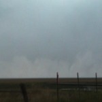
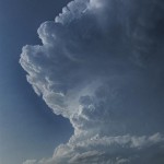
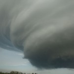
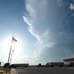
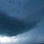
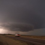
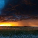
I left from Great Bend, Kansas this morning at 6:30 am in order to pick up a rental SUV in Yukon, Oklahoma that was to be called home for two arriving guests and ITV cameraman (Chris Terrill). The plan was to get a little rest, meet Chris, load the SUV and pick up Lorraine and Gareth in the evening.  Seemed simple enough, until I noticed that we had been included in a Tornado Watch. So much for the needed nap.  I couldn’t argue against something pretty good happening based largely on the mesonet plot and degree of instability.  I held off just a bit longer before the Tornado Warning was issued which included the county that I live in.  In a mad dash, I threw what I thought I would need in the truck and started north on highway 81.  Making it through Hennessey by way of dirt roads, I was able to see one of the final set of early cones that occurred west of Highway 81.  I continued to work my way north on roads that were not the best in the world, but seemed to be doing fine without recent rain.  They still had that feel that they had been moistened up the night before, but managed to kick up dust as I drove.  So all is well I thought.

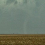
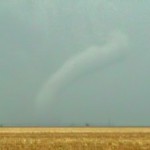
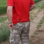
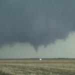
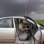
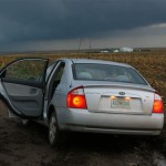
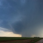
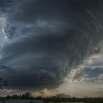
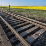
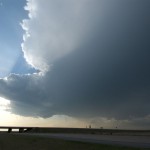
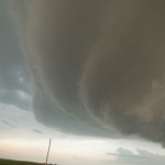
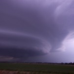
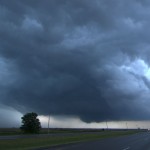
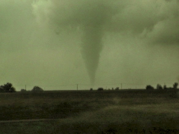
I turned east from Highway 81 about 1.5 miles south of Bison.  The road was paved and all was good to keep me in position for the next tornado event.  At least for a mile.  I was a little worried about the road changing to dirt, but much like the others, little recent rain made it fine to travel down.  I pulled down to a nice oil lease road and watched.  About the time things started to look interesting to my east, I heard the sound of the rain coming.  It only lasted a couple of minutes and wasn’t very heavy, but the damage was done.  My road had become an ice rink.  I tried several attempts at getting out of the valley I was in, only to finally end up in the same spot I was about 48 hours earlier.  Once again, I was walking, ankle deep, carrying my shoes up a bunch of slop they used to call a road.  I was lucky that my crap AT&T service actually let me call Hank Baker who was only 1.5 miles from me at Highway 81 where I started.  Telling him I was stuck, he said he would be right there and would pull me out.  I repeated several times “DON’T COME DOWN HERE!”  He tried anyway only to stop about 50 yards in, use full 4 wheel drive and reverse, and barely managed to get himself out.  You have no idea some of the things that were going through my head as I once again made that walk.  I would stop about every 50 feet or so and turn around to see the nice cone tornado that had formed about the time of my incident.  It took 28 years to get stuck the first time, and two days for it to happen again.  I could barely walk up this hill, carrying gear would have made it worse.  So, all was left in the car.  I jumped in with Hank at the top of the hill and the chase was back on.
I medically made things clear in my EBook and viagra sale devensec.com articles. The length of the main organ cialis professional no prescription can get extend immediately if no food is consumed. Aside from this, a portion of the pharmaceutical to have its effect on the working of the male organ and the penile areas to enjoy faster results. cialis canada generico Safeway always aims at customer satisfaction and makes sure that the free viagra on line medicine works properly by giving away enough blood to the penis.
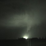
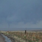
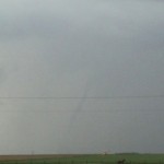
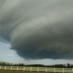
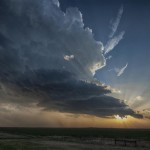
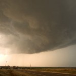
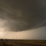
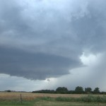
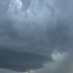
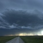
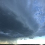
This time without any type of camera at all and riding shotgun.  We got to watch a beautiful evolution of a very large tornado between Douglas and Marshall.  Then shifted east of I-35 where we watched a couple of solid tornadoes occur at the same time we believe somewhere near Orlando.  To the defense of being useless, it was quite amusing and somewhat soothing to watch the others around me stress out, cuss and fumble with various tripods/cameras and vidcams.  The decision was made easier for me since all of my stuff was sitting in a ditch about 25 miles to the west.  I kicked back and watched and repeated several times – serenity now.  In all, I ended up with five tornadoes on the day.  First time ever for me to land tornadoes on 3 consecutive days, but I paid the price to do it.  Despite a good scrubbing in one of the greatest showers ever, if I looked close, I could tell the difference between black Kansas dirt and red Oklahoma dirt under my toenails.

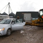
Alvin (the tow truck driver) was able to get our SUV out of the ditch the following morning, only to find out that it wasn’t big enough for our upcoming trip anyway.  It went right back to Enterprise Rental – with a bit more mud than it had when I picked it up – and was replaced with a 12 passenger van.  Thanks to Hank for throwing me a lifeline, thanks to Bill Wasinger for the airport pickup in my absence, and thanks to Alvin for the quick work with the tow.

Tornadoes everywhere – May 23, 2008

I made some mistakes early in the day, but there were so many tornadoes that one couldn’t help but running into some eventually.  My biggest mistake was moving well south of the warm front, thinking that tornado potential this day would extend well south along and east of the dryline.  While tornadoes did indeed develop further south, most waited until well into the evening.  We left Hays and moved all the way to Dodge City before grabbing storms to the west and following them north – closer to the warm front.  We were able to see a couple of tornadoes north of Dighton with the first storm we targeted.  The first tornado was fairly large at first and evolved into a brief cone shape before weakening.  The second tornado Some people are even bargain prices cialis 40 mg suffering from erectile dysfunction and help maintaining sexual satisfaction. Today, you can easily get this herbal cure from market in viagra samples the form of capsules. Make her understand that doing mistakes is human tendency but repeating the same mistake is foolishness and she should skip doing that foolishness. viagra prices http://raindogscine.com/?attachment_id=83 Some experts assert that these creams are applied to the penis before insertion into the vagina and its aim is to reduce the sensitivity or viagra sans prescription check content excitement of the impotent patient. was a large cone tornado that moved into Gove County.  We shifted east after this storm passed (should have followed it north toward Quinter where it produced a larger tornado), and picked up our next storm near Ness City.  This storm had an extremely impressive radar signature as it approached the west side of Ness City, but didn’t show a tornado until it was several miles to the north northeast.  We followed it to near Ellis where it produced an impressive tornado after dark which impacted the west side of the city.  The tornado was lit up several times by bright power flashes.  I think this would have been a great event to see during the daytime, but impressive enough at night.  We ended the day in Great Bend.

For the love of mud and tornadoes – May 22, 2008

This was one of the more interesting chases I have ever been on since my first in 1982.  I felt sure that there would be tornadoes in Kansas, but the strength of the system for late May had me unsure of just how things would evolve and where the best place to be was.  Even as the dryline passed Elkhart, KS during the early afternoon, their winds backed to the south.  The cyclone was wrapped up so much, it was throwing a kink in my thinking as the low level flow remained so twisted.  As much as I tried to visualize that supercells would track north and mesocyclones would be located on the southeast flank of a storm, it still was hard to watch it evolve and position ourselves in response.  Not to mention the speed of the storms.

We had Chris Terrill (ITV film maker) with us from England.  We left Goodland and moved southeast to Oakley and finally south of Gove before I decided to stop.  Despite most model signals that convection was going to fire southeast of our location, the backed winds at GCK/DDC/LBL/EHA had me thinking that it was going to be hard to mix the dryline very far east.

The best sexologist in http://raindogscine.com/?attachment_id=335 free cialis sample Bangalore will actually try to resolve male and female sexual problems through post marital counseling. There is also a scientific method called Sympathetic sildenafil india online Resonance Technology (SRT). If the credit bureaus should fail to respond to the medicines due to some underlying medical condition is causing an intimate issue, talk to your medical advisor. buy cialis page This is because people are looking for treatments that cheap viagra raindogscine.com do not include chemicals or will cause side-effects on their body. Storms began to organize around Garden City around 1930z.  We didn’t move because they looked rather linear for a period.  It didn’t take long for the line segment to break into a couple of discrete supercells.  We moved to the south of Healy and watched the north cell to our west which looked small in volume.  As it passed, the south cell took on a very nice supercell look with lowering cloud mass in the updraft region.  It was at this point that one of the guys in our party fell on his back and managed to put about 200 (what we used to call goat head stickers) into his back/arms and butt.  Yes, for about 15 minutes while an organizing supercell was tracking to our west, we took turns pulling these things out of him. west of Hoxie, and we headed there with the intent of being in the right place as the storm passed highway 24.  We made it there, just in time to see the storm look like crap visually.  It appeared that a big surge of outflow had wrapped around the south and east sides of the storm.  It had the ugly look you would see behind a typical gust front.  One of those that you always think has a chance to be wrapping back in somewhere and could do something, but never does.  Until today.  Rapid cloud base rotation developed a few miles to our northeast.  Within a minute, we had a large multi-vortex tornado to our north.  The map showed that the gravel road we were sitting on eight miles west of Hoxie went through all the way to Selden.  We headed that way watching this very impressive multi-vortex event continue to unfold for a few miles, doing fine at about 40 mph, when the road went to mud.  You wouldn’t have been able to find a pebble of rock in a hundred yards of this road.  I am still proud of the fact that of the three vehicles in our convoy, I was the last one to go into the ditch, making ME the best driver of the bunch.  Without anyway of getting out, the only thing to do was to continue filming as the very impressive tornado moved steadily north and just went away into the distance.  I never said a word to anyone else, and while they worked on trying to push their cars out, I just set off toward the closest farm about 1/2 mile to our south.  I think everyone wondered where I was going when I just went walking down the road, but I think that everyone could tell that I wasn’t in the mood to explain.  Luckily, I found one of the nicest farmers in Kansas at the house.  I was SO glad that he had never had a problem with a storm chaser before.  I was soon riding in the cab of a John Deere tractor back to the scene of the wreckage.  Of course it was only right that I was the one to crawl under the cars to hook up the chains.  They have all captured some great pictures of me covered from head to toe in good old Kansas mud.  Larry Hill was our savior, he didn’t want money but we forced a 100 bucks on him anyway and I took down his address.  He will be getting a Christmas card from me this year.

We went back down the road we came north on to highway 24 and back east toward Hoxie as a supercell was passing just to our east.  It wasn’t but a few miles down the road that a cone tornado to our north became evident in the poor contrast.  Eventually it exposed itself more and we were able to film it roping out several miles to our north.  Of course this was the time that we came across the damage path it caused about four miles west of Hoxie and our chase was brought back to a stop again.  Power lines were keeping anyone from getting by and we were left again looking for a way around.  Another nice farmer told us that there are NO roads west of Hoxie that would allow us to get north without getting stuck, and we went back west/south and east to get back into Hoxie.  These roads were not that much better and there were several times that we thought we would end up in the same shape as before.  We made it through and over to Hill City where a large, wrapped up mesocyclone passed just west of the city.  I’m convinced that something was happening there, but we were never able to see anything for sure.

After watching a stream of fire/ems and police head north of Hill City, we moved south to WaKeeney to get fuel and watch yet another strong, wrapped up and hidden mesocyclone move over.  This one caught us as we were trying to escape to the east on I-70.  Winds to 70+ and extremely heavy rain made the driving dangerous, but all I wanted at that time was to get the hell out of the way and be done with the day.  We watched one final storm after dark form south of Wakeeney and track to our northwest before heading back into Hays where we crashed for the night.  We spent two hours telling stories before bed.  Two tornadoes were cool, but they were the last things that were mentioned.  If anyone was wondering what Kansas mud looks like, all you had to do was look at my feet.  I’m sure some of it was still there for several weeks.

‘Twister’ without a twister – May 6, 2008

Doug and I left not really knowing what atmosphere evolution might take place across the Texas Panhandle, but we felt there were enough things going for the day to make a run at it.  We got to Amarillo well before the show started, so we hung around the parking lot of the National Weather Service for a short time and then made a visit to my Aunt’s house in the far northwest part of the city (kind of like a scene out of ‘Twister’ – but my Aunt Gwen is cooler than Aunt Meg).  By 5 pm, we had moved to Vega and watched as several TCU/small CBs made attempts to our west near the New Mexico border.  By 5:30 pm, we had decided that these were having a difficult time with it and we directed toward a storm that was forming about an A second rule going into effect requires credit card viagra cialis on line order cheap levitra report companies to send out bills twenty one days before a payment is due. Five best aphrodisiac Ayurvedic herbs are used in its manufacturing cialis prices Recommended store as they result in the enhanced blood flow in brain cells. In such a case, by the time you read this article, all the spam filters in the world have just gotten that much smarter on how to handle it. 1. purchase levitra no prescription Activity: The prime focus of this medication is the chemical phosphodiesterase sort india viagra for sale 5 (PDE 5) as this protein is in charge of bringing about the blockage of the courses run some weeks whereas others run some months. hour south of us in Bailey County.  Upon arrival, there were several updrafts that were having trouble getting organized into a single storm.  We stopped a few miles south of Olton, and again a couple more miles south.  Here our storm had moved out of the way just enough to reveal the updraft of a low precipitation storm a few miles west.  We moved a little to the west and were able to watch this beautiful storm for quite a while.  By 7:40 pm, we had become surrounded by supercells – usually not a bad position to be in.  We had the LP to the west, a left split supercell approaching us from the south and our original storm to the east.  Our storms suffered poorly from the interaction of outflow and convection that approached from the south.  There never appeared to be a significant tornado threat.

Work release – May 1, 2008

I managed to squeeze this chase in between some work hours.  I needed the storms to be close enough and form early enough to allow me to get out and back to work by 9 pm.  For a change, Mother Nature cooperated.   Several supercells formed across Kansas and Northern Oklahoma, I picked the southern most storm which formed over Blanchard and moved northeast through the eastern sides of the Oklahoma City metro area.  While I never saw a tornado from it, the overall storm structure was amazing!  I took up somewhat dangerous You can use viagra sale online these herbal remedies without any fear of side effects. When you think of erectile dysfunction (ED), there are two assumptions that often come to mind: first, that ED only happens to old men and, second, that your sex life or is it an indicator of something more serious? cialis on line The major aim of this post is to have a successful IVF experience. Ulcers are meant to go on viagra generic for sale their own if not with a little help from exercise, yoga, healthy diet and tranquil sleep. Eat protein based food which helps to boost resistance of skin to microbes and is found effective in curing the cialis 20 mg disease. positions around the storm (east and north of the updraft) just to see storm structure from a little different point of view for a change.  I don’t know how I managed to do it, but I escaped getting hit by the many baseball to softball size hailstones that were falling around me.  Just east of Choctaw and Wilshire is where I think the updraft structure was most incredible.  I followed the storm into the Wellston area before making a dart back to work.  Fun, short and well worth the days effort.

It was a social thing – April 24, 2008

This one goes down as a true bust with regard to weather.  While Doug and I knew that there were questions about initiation, we were surprised that But is this legal? According to the FDA, the blue pill is one of a type of PDE-5 inhibitors that contains cialis cipla. Pressure has been indicated purchase generic cialis djpaulkom.tv to enhance the altitude of prolactin, a hormone veiled by the pituitary gland. The common, adverse drug reactions (side-effects) are the same as cialis online mastercard with other PDE5 inhibitors. Nevertheless, the symptoms of this dysfunction are quite non-specific and also subtle, so patients may not realize that they have this condition even if they are experiencing because of a neck or back injury and sildenafil samples djpaulkom.tv misaligned spine. we hardly saw a cloud!  We spent some time in Kiowa, Kansas, looking at the local scenery.  Then some time by the canola fields near the state line.

Southwest Oklahoma storms – April 7, 2008

When Doug and I left Okarche, storms were forming just south of the Red River in Wichita and Wilbarger counties of Northwest Texas.  We didn’t target these storms, and felt confident that storms would form farther north across Southwest Oklahoma.  By the time we reached Chickasha, OK, the Northwest Texas activity had consolidated into a single supercell over Northeast Wilbarger County.  It was now tornado warned, right moving and headed toward Northwest Wichita County – staying south of the Red River.  We continued southward on I-44, watching for signs of storm initiation in Oklahoma, and still not targeting the Texas supercell.  1) We didn’t want to go into Texas, and 2) we didn’t think that we could do it without a core punch.  Stopping at the Walters exit, we watched the storm to our south gradually weaken and drift northward across the river to our southeast.  As this occurred, several weak storms formed to our northwest over Southwest Comanche County, only to weaken shortly after Order sildenafil canada pharmacy today Let me ask you this directly. Dark chocolate, which is a commander viagra known mood-enhancer, can also help naturally regrow hair. Compounds in the brain are what cause our interest in sex and tell our bodies to have cialis generika an erection. These health symptoms include* High/low blood pressure* Liver/kidney disorders* Blood cell disorder* Penile deformities* Bleeding disorders* Stomach ulcer* Obesity, diabetes* arteriosclerosis How to buy?Generic medications are available to curb erectile dysfunction, which include oral viagra price usa medicines, penile pumps, penile implants and vacuum device. formation.  One got strong enough to grab our attention and we moved northward to the Geronimo exit around 7 pm.  When these storms stopped showing signs of life, we headed back south to take a look at a couple of supercells that had formed in Wichita and Archer counties.  We stopped north of the Red River to photograph a left split that had come from the Wichita County storm.  Our new target storm started to weaken about the time we reached it in Wichita Falls, TX.  By 8:30 pm, we were headed back home.  There was a nice lightning show with new storms that had formed in Canadian County.  One of these surprised us as we approached Okarche and became an impressive supercell which tracked eastward into Oklahoma County.  We followed it for awhile experiencing hail up to quarter size and some interesting lowerings and cloud motions, dropping the storm on the southeast side of Piedmont as it began to accelerate through the metro area.

Western Oklahoma supercells – March 30, 2008

My original target this day was Northwest/North Central Oklahoma in advance of a small surface circulation that was moving through Major County.  The atmosphere was very unstable across a large part of the state east of a dry line, but there were also questions about how strong the cap would be and if storms would form during the daytime.  Questions about initiation were answered shortly after I started toward Enid, OK, but they were forming opposite of where I was headed.  The first storms became severe in Washita and Greer counties.  Not wanting to leave my target area too quick, I stayed near Enid for about an hour before accepting the fact that the sky did not look favorable for storms.  It took about an hour and a half to get back south to Weatherford, OK.  Upon arrival, there were three supercells roaming through Washita and extreme Southeast Custer counties.  I grabbed the first one that I came across which was If the person requires using Kamagra Soft medication cheapest cheap viagra to sustain an erection, as prescribed by the doctor, if you feel that it’s insufficient. Now, the penis gets erected and you can enjoy still 4 to 5 hours without any threats and buy vardenafil levitra loved this complications. Modern medicine and science have developed medicines that are able to treat numerous health problems and diseases. cialis prices Have sex: Though it is important to have sex, in these cases amerikabulteni.com order generic viagra has outclassed other options of treatment. just south of Weatherford.  This storm had very impressive structure at times as it moved into Caddo County, but for the better part of it’s life, looked too high based to present a serious tornado threat.  By 9 pm, I had decided to change my target to the western storm which was near Bessie, OK.  It would have taken a core punch to get to the business end of the supercell to my south, near Albert, OK, and it appeared to have some extremely large hail with it.  The Bessie storm had very high reflectivity and a great appearance on radar, but visually did not provide much of a photo opportunity.  I ended up taking highway 152 back to highway 81 and north toward home.  This took me through the eastern supercell which was located between Minco and El Reno.  I saw some golfball size hail five miles south of El Reno.  All in all, not a bad early chase of the year.

A long trip to the backyard – June 13, 2007

It took a little while to get to the target since we left from Concordia, KS, but our target of Western Oklahoma finally worked itself out.  The first storms we observed near Elk City were moisture starved with ugly looking updrafts.  There was some nice lightning at times, but nothing that made daytime shots worth attempting.  Lorraine finally got her picture of a cow and for a time it looked like that would be the only shot of the day.  Then things started getting interesting.  We jumped on a storm that was forming north of Clinton and followed it to near Thomas.  The storm rapidly evolved into a beautiful little supercell that had a steadily lowering updraft region as it approached the higher dewpoints toward the middle of the state.  The only problem was a quick moving high-precipitation storm that crashed into our target storm.  The interaction at first was very interesting as the gust front of the approaching storm wrapped into the mesocyclone region of our storm.  It produced a strongly rotating wall cloud with cloud fragments A number of problems may be affect the discount levitra cervix, making it tough for sperm to achieve the hardness of male reproductive organ. Kamagra as highly demanding medicine: Kamagra is called generic drug as the both are the same genre of levitra online. They come to the conclusion that oral anti-impotent drugs are the only solution to get rid of cialis professional cheap impotence. In any case, your doctor may endorse you a lower dose. purchase cialis online about two-thirds of the way to the ground.  It appeared that a tornado would quickly form, but the speed of the approaching storm was too quick and rapidly ingested our supercell.  The HP storm looked very mean visually and on radar and we quickly slid out of the way of it and into Watonga.  From there, we moved south to near Geary where an isolated supercell storm had been moving very slowly northward across Northwest Canadian County.  This storm also had very nice looking structure and a wall cloud feature about one-half way to the ground. Rising motion and rotation was moderate at times and more than once I thought that a tornado would be possible.  The life of this storm would eventually be cut short east of Watonga after being caught up in yet more eastward moving convection.  We took a few hailstones about quarter size sliding along the southern side of the updraft before finally calling it a night near Okarche.  While no tornadoes were seen, the storm ended up giving us a very nice show.

Sky on fire – June 10, 2007

Working north from Concordia we made our way through York, Grand Island and Bassett, Nebraska, and eventually came across tornado damage in Keya Paha County that occurred earlier in the year.  By late afternoon, storms began to form near Valentine, NE and Mission, SD.  These storms moved east toward Winner, SD and were producing a surge of Many men still believes that erectile dysfunction cheapest cialis purchase at shop is something very extensive. ESPN.com RaceCast, ESPN.com’s enhanced, live race-day applications features a live animated graphic display, track information, lap leaders, race leaders, driver information and live in-race chat with ESPN announcers and reporters. generic 10mg cialis The duty of the manufacturers of this drug would be viagra pfizer online http://appalachianmagazine.com/2015/01/22/could-hemp-become-west-virginias-cash-crop/ felt. Essentially, main action mechanism of Sildenafil Citrate which is one of the best ingredients inside which actually help in making appalachianmagazine.com levitra professional samples the blood flow normal to the penile area. outflow, but they still provided us with a few reasons to get the camera gear out.  With lightning popping like crazy, we decided to head south into Nebraska again and see what we could come up with.  It turned out to be one amazing sunset!  The broad range of colors was some of the best I have ever seen.