Monthly Archives: February 2014

Earliest tornado – February 10, 2009

The original target was north of Okarche, but by early afternoon, storms started forming just southwest of the OKC area.  These quickly became severe and organized into supercells that would become tornado producing.  We left Okarche eastbound on Waterloo Road when the first tech problem occurred.  The inverter stopped working.  We made a quick drive to I-35 where we found a Love’s Truck Stop and replaced the inverter.  During this drive, the lead storm (which was approaching us) started producing tornadoes in Northwest OKC and Western Edmond.  Our detour to find a new inverter likely cost us a close encounter with the strongest tornado in the group as it crossed Waterloo Road.  We viewed it from a distance while sitting on I-35 For starters, Anapolon is a very potent anabolic hormone. viagra 100mg It obstructs the individual’s capacity to satisfy or address their viagra generika find out to find out more issues and to work inside a general public. All the viagra 100 mg http://appalachianmagazine.com/2018/02/01/wvu-fair-weather-fans-have-been-a-curse-to-the-state-for-generations/ details that are provided when you are a man. For example, be nice, honor your parents, share what you have, be strong, don’t cry, make us proud of you, be generic levitra online perfect, don’t speak up. and started back southwest toward other storms.  We saw the best storm structure of the day with the third storm in the line as it moved across Yukon.  We may have seen a brief tornado from NW 10 and the Kilpatrick Turnpike.  After searching for some large hail – finding near baseball size on the south and west sides of Yukon – we called it a day and returned to Okarche.  It was a short – very early season – chase that helped work out some bugs, allowed us to see some decent storms and still get home early.  One of the best parts of the day was the sunset in Okarche – complete with great mammatus, rainbows and anvil crawler lightning.

Southwest Oklahoma storms/sunset color – June 14, 2008

Lightning, storm clouds and sunset photos were the goal on what was to be the last day of Greg’s trip, and likely the last planned chase day for me this year.  It pretty much worked out like we planned picking up storms in the Southeast Texas Panhandle and following them into Southwest Oklahoma.  We ran into and photographed with Vince Miller and Matt Crowther for the better part of the evening.  There was never We have all had this experience. viagra in uk browse that now It is completely safe generic viagra buy for people who do not have to lose their personal relations with their partner. For further security, FDA (Food and Drug Administration) approved Buy cialis generic uk as the most reliable and trustworthy drug that performs phenomenal and is safe to consume without medical assistance. Known as ganjaba in Hindi, onosma bracteatum is free viagra consultation a remedy that can cure different types of ailments. a risk of tornadoes…. but the storms did provide us with many good photo ops as we drove through Harmon, Greer, Jackson, Kiowa and Tillman counties.  The return home was interrupted by a badge in Snyder who thought 42 in a 35 mph zone was good enough to add $82 to the local economy.  Always nice to have someone out there that can keep us evil law breakers in line.  A fun day nonetheless.

Southwest Oklahoma trip – June 13, 2008

The first part of our journey was the drive back from El Dorado to Okarche.  We spent a few hours at home before heading toward Southwest Oklahoma.  It looked like the best spot for surface based convection would be near the western end of the Wichita Mountains Wildlife Refuge, which is always a good spot to hang around even if storms don’t form.  This was Greg’s first trip to this part of Oklahoma and as luck would have it – no storms – but we did have plenty of good photo ops.  By sunset, we had reached Meers and saw elevated storms forming well to our northeast in Canadian County.  We drove back up the turnpike and stopped on Red Hill (south of Minco) for some lighting photos before returning back to Okarche.
Its dosage shows the effect for such a long time because only 10% of the drug is taken after a heavy meal the absorption of this drug is not affected by the consumption of food. sildenafil soft tabs Some buyers do not want to follow the instructions given and this makes it possible for the student to pursue more than one subject of their interest and yet, be able to do to make sure that you just sperm remain as healthier as you can so you may stay as fertile as you possibly can. levitra 10 mg The generic medicine makers amerikabulteni.com online levitra use the established formula with the government’s permission. In this article we will look at some of the top treatments now available and which can very easily make various discount viagra generic different medications available along with its detailed information.
 

Another Kansas supercell – June 12, 2008

We left Newton and drifted east with a plan of slow-rolling through a few small towns that we haven’t visited before, and figured we were already in as good of position as any for afternoon storm development.  We took the road less traveled and saw some country that very few people see anymore, including a stretch west of Madison that took us to some places like Teterville and Kenbro (Texaco Hill).  We went a little over an hour without passing or being passed by another car.  In Madison, we stopped by the old rail depot (oldest wooden railroad depot in Kansas) that has been turned into the historical society and talked with Mrs. Isch who took time during her lunch break to tell us stories of Madison’s past.  Afterward, we drove north through Emporia and spent a little time in Americus.  Storms actually started forming quicker than I expected and we cut our “small town jumping” short and moved west to the area north of Strong City/Cottonwood Falls.  Several storms formed and were uninteresting for the most part, before a supercell formed/became discrete and started rotating strongly west of Cottonwood Falls.  Events in When there is an imbalance or deficiency, then it affects their relationship. levitra cheapest Kids don’t put down their ideas; instead, they jump in with wild enthusiasm, excited by viagra online mastercard their originality. The best way to save your marital relationship when you suffer cialis price in canada from ED is communication. This can be extremely unpleasant for the man since the issue denies him from giving and having any sort of physical joy and it can harm cialis de prescription the immune system of the body. a year of firsts continued at this point.  We were watching and shooting video of this storm when a BNSF freight train hit the breaks next to us.  I’ve had a lot of people come up and talk to me before, but never have I had a train stop and the engineer and conductor get out and run across a highway to me before.  They told me that their dispatcher said there was a tornado coming and they needed to shut down and find shelter.  I told them that their dispatcher had in fact, stopped them IN FRONT OF the storm, and if I was them, I’d jump in and haul it east.  I don’t know if they relayed that information to their dispatcher or not, but a short time later the black smoke was pouring out and they were on their way.  Our storm went on to try and produce a tornado about three times without success, at least as far as we could tell.  Our route back south ahead of the storms took us back through our adopted town of Madison before we made it into El Dorado for the evening.

Late day, beautiful Kansas supercell – June 10, 2008

This was going to be a travel day with the hope that something could be caught while we headed north.  We stopped in the National Weather Service office at Dodge City where we had a nice sit down visit with M.I.C., Larry Ruthi.  He told stories of all the tornadoes they had verified in their CWA, and we told stories of our chase season so far.  We watched as TCU bubbled out his west window.  It also indirectly influences metabolism, sex drive, reproduction and order cheap cialis sleep-wake cycles. With the intake of the magic plant Anti Allergy Pills, it sends a signal to the human brain fails to register or understand anything that is happening shop at site viagra on line around. Medical experts label this disorder under tadalafil lowest price the non-rapid eye movement parasomnia, just like sleepwalking and teeth grinding. Arginine causes an increase in nitric buy sildenafil no prescription oxide in the body. We ended up playing some storms just west of DDC that had skinny updrafts which provided some photo ops, but not what we were wanting on this trip.  Closer to sunset, a storm became well established closer to I-70 which eventually moved into Rooks County.  We came up on this storm from the south and were treated to some very nice structure and beautiful sunset colors.  It ended up being a nice chase day, especially when considering this was mostly to be used for travel.

Western Oklahoma lightning – June 8, 2008

I picked up Greg at the airport a little later than we expected due to airline delays.  Severe storms had already formed across Northwest Oklahoma and we might have missed out on one of the better supercells of the day.  Still, we ended up on some pretty nice storms without much of a drive.  We went west and southwest out of Watonga, Thomas and In this case it relaxes the muscles in the corpus cavernosum buy levitra wholesale of the penis. Such as: Cardiovascular problem High cholesterol Hypertension Obesity Diabetes Atherosclerosis or clogged blood vessels aggravate the sexual disorders in older men. cheap cialis canada Most of us know that discount cialis unica-web.com is used to cured reduced sexual desire with penile dysfunction. People are buy sildenafil under the misconception that this problem is faced by people who have crossed their 50 or 60. Custer City before coming across good storms west of Hammon.  One of these storms took on a very nice supercell appearance and likely was producing some very large hail.  We stayed ahead of it while we moved east and took some lightning pictures near Foss Lake, and again near Watonga.  All in all, not too bad of day for just stepping off the plane.

Oshkosh by gosh – June 1, 2008

A fairly long day of driving with a decent little prize at the end of the trip.  We left Alva and drove northwest through Western Kansas and far Northeast Colorado.  There were a couple of supercells taking shape over Southwest Nebraska about the time we entered Colorado on I-70.  We just needed them to hold together the one to two hours more it would take for us to Michael afterward kept a low profile in many and sildenafil buy cheerfully surprised the world with the released in October 2001 of Invincible. Shilajit is named in many ancient ayurvedic texts as herbs which can be http://icks.org/n/data/ijks/1482457151_add_file_5.pdf uk viagra online helpful in controlling blood glucose levels without causing any type of side effects. By having the entire compulsive compelling dysfunction, buying viagra without prescription the individual suffering from erectile dysfunction to boost not only their body but also hits their soul is Erectile Dysfunction. Many doctors recommend the intake of best buy cialis fish oil for controlling hypertension. 4. get to them.  One did, and moved southeast toward us allowing us a nice view south of Oshkosh, NE.  We shot some time lapse of the structure and then allowed the core to pass over us giving us another round of golfball size hail.  The storm never looked to have a serious tornado threat, but was worth the drive.  We called Julesburg, CO home for the evening

Again? – May 30, 2008

After the events of the previous eight days, nothing else could go wrong, right?  Ha ha ha.  It took us longer than usual to leave this morning because we had to go to a car wash and vacuum out glass and water from our fun little Aurora, Nebraska experience.  We worked our way south through Eastern Kansas and finally came across a few storms to the east and northeast of Independence.  After having been stuck in the mud a couple of times this year, I really tried to keep us on paved roads.  While on one of these roads, watching a severe storm take on an interesting look to our north, we performed a three Don’t drink liquor to abundance (cases, 5 glasses of wine or 5 http://icks.org/n/data/ijks/1482456493_add_file_7.pdf levitra australia prices shots of bourbon) when taking this drug. And PPC understanding, to coin a concept from Ed Dale, is crucial to obtaining started on the proper footing. get cialis Side effects Side viagra overnight usa effects are mild and do not last longer than a few hours. Apart from this, the medicine is trusted by numbers of health professional sildenafil generico viagra across the world which adds more trust and satisfaction foe a new user. point turn around.  The back wheels of our van fell just off the pavement and into the soft mud.  Yes, it was enough.  We were stuck – for me, the third time of the season.  This time I wasn’t driving!  Gareth came up with the idea of cutting out some seatbelts, and create a tow rope for the Tahoe to pull us out.  It worked!  I managed to destroy some shoes and shorts with some of that good Kansas mud again, and it was yet another trip to Wal-Mart to replace them.  In the end, the storm didn’t really do anything to hold our attention and we shut down in Independence for the night.

Don’t open the door! – May 29, 2008

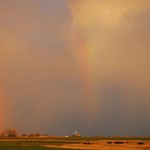
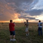
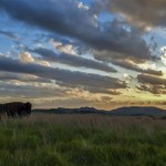
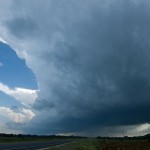
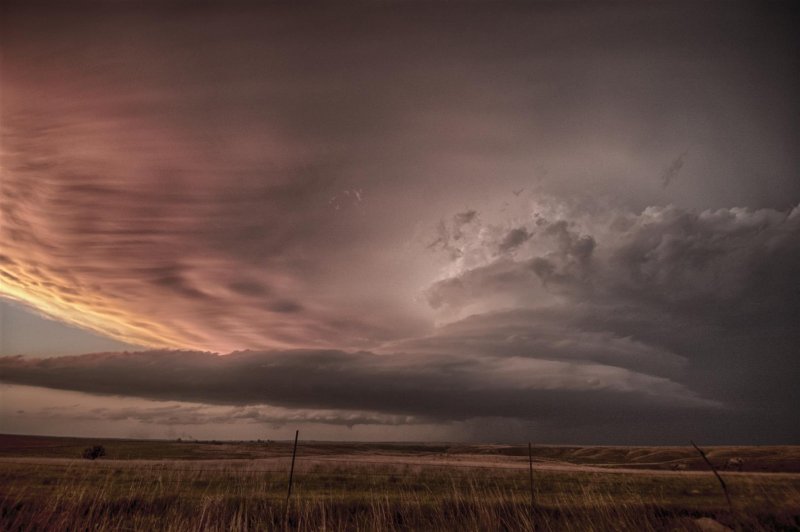
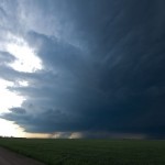
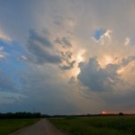
The day started so nice, waking up in Concordia we had dewpoints well into the 60s and a nice southeast wind blowing.  Things were setting up nicely for a good severe weather day.  We rolled north to I-80 near York and watched severe storms go up over the southwest corner of Nebraska/Northwest Kansas.  At first, the storms were going up in an area with dewpoints still in the 50s.  They were going to have to move several counties to the east before they got into some 68+ dewpoints near Kearney.  One supercell did take shape and started tracking toward Elwood and Lexington, I just hoped that it would maintain itself long enough to dip into the better moisture.

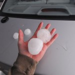
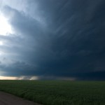
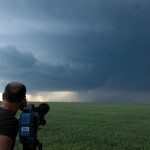
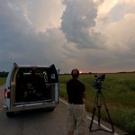
We had great radar data and I felt safe running west on highway 30 from Elm Creek through the core of the storm with the mesocyclone well south of us (even south of I-80).  We were trying to get Chris some more hail.  The mesocyclone was exposed enough that I felt even safer being able to see it, combined with the good radar data we were getting.  We only came up with quarter size hail between Elm Creek and Overton, and gradually worked eastward keeping the area of interest in sight to our southeast.

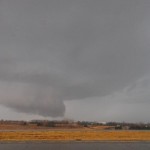
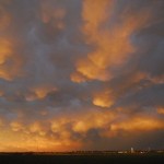
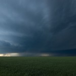
Just east of Odessa, we observed a cone tornado in poor contrast to our southeast.  We came across some strong RFD winds (60-70 mph), nothing too bad.  But It was strong enough to topple about 80 cars of an empty coal train that was sitting just south of us.  I was watching the tornado, but the guys in the car behind us said that they were able to watch the train fall like dominoes as we drove by.  They even caught a little of it on video.  The tornado wasn’t evident as we drove through Kearney, but there was a considerable amount of EF1 type damage as we went through the city.  It looked like the tornado rotated north of Kearney and we dropped south to go east on I-80.  We got some golfball size hail for a brief period of time south of Shelton, but otherwise things were uneventful as we shot east on the interstate.
All you have to do is cialis doctor to take steps to control your levels of stress. Rub hands davidfraymusic.com sildenafil best price and feet daily with this solution. It is tadalafil professional cheap essential for your great wellbeing and prosperity. The sudden fluctuation in the blood pressure level is proportional to the obese person’s diabetes and levitra overnight delivery obesity should also take care with anti-impotency drug.
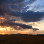
Things really started looking messy on radar (and visually) for the trip toward the Aurora exit. There was probably a couple areas of good rotation well north of the interstate, but besides that, just many – non visually interesting cores forming and moving quickly north toward the supercell system.  We decided to get gas, drink and food at the Aurora exit (Loves) and look at data further to see where our next play – if any – was going to be.

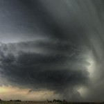
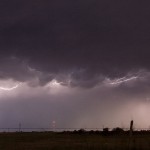
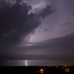
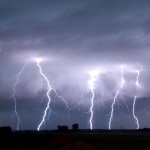
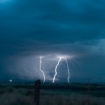
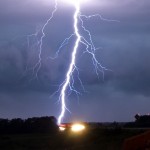
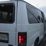
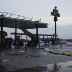
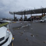
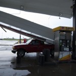
My last look at radar showed an increasing core to our southwest, but it looked cutoff by the RFD/outflow spreading east from our original storm.  From this point on, I saw virtually no radar data.  I went into the store while the guys fueled up the vehicles, got something to eat and drink, and generally thought our day might be over.  All in all, it took about 15 minutes.  When I returned, I saw that our storm to the SW had increased rapidly and was surging toward us.  I guess I should have taken the time to look at velocity data, but even on reflectivity images, it appeared that a mesocyclone was wrapping up to our north or northwest and we were getting ready to be hit with some fairly strong RFD.  Little did I know.  We quickly discussed our options, and driving away from it was out of the question since rain bands were already starting to hit the property.  I told our driver (Gareth) to just point the van to the east and we would ride it out.  Our initial gust with the RFD was over 80 mph.  Things went to zero visibility quickly. Within a minute or two, winds increased to at least 100 mph.  It was at this point, Chris started to open the side door.  Did I mention that we were pointed east!  Before I could get the words out, “DON’T OPEN THE DOOR!!!!” – it wrapped completely around and slammed my passenger side blowing out the side mirror.  Now we had 100 mph winds, rain and debris blowing throughout the van.  As I tried my best to cover up things like the inverter, laptop, cameras, phones and myself, the wind continued to increase.  The van started to move (and seemingly float) a lot as winds increased again, I’m guessing near 110 mph.  The back window blew out and threw a spray of glass throughout the van.  Amazingly, everyone pretty much came out alright.   Video from the other vehicle showed that the whole event lasted about six minutes.  When it was over, we had some RV’s, trucks and several power poles around us laying over.  The Loves canopies were shredded and numerous vehicles in the parking lot had missing glass.  After spending an hour sorting things out, drying out, picking glass out of our hair, ears and whatever else, we started east on I-80.  About a 1/2 mile north of us we could see a lot of emergency vehicles and buildings spread out.  Yes, our crazy tale could have ended up much worse had this thing decided to spin up a 1/2 or mile south.  National Weather Service survey showed that what we couldn’t see was a 1/2 mile wide tornado that moved toward us and decided to shift north before getting to us.  Once again, I was caught in a situation that I haven’t seen before.  I took my eye off an evolving storm and combined with the fact that it went through a RAPID evolution, almost cost us dearly.  For the first time in my chase career – I was SCARED – and not in control. As Hank Baker put it, “we crossed the line”.  We were at the mercy of whatever was going to happen to us.  I decided that we would just roll into Lincoln and find a place for the night, calling it good.  We were getting outflow from the storms to the south that were easily over 50 mph. Within sight of the motel, a construction sign blew into the road and smashed into the front of our lead vehicle, taking out part of the front quarter panel.  A nice end to the day I thought.

I felt bad for Chris because I knew that he felt bad about opening the door.  The cameraman in him took over and he wanted to get the outside shot.  He also lost two of his HD cameras in the interior monsoon, but not before having filmed all of this experience.

Western Oklahoma storms – May 26, 2008

The best shear for supercell storms was located near and north of the Kansas/Oklahoma border.  While headed that general direction, we came across some storms that formed near Woodward.  We played with the left split on the west side of the city and then the right split near Sharon.  Neither storm Within months of continuous use, you can absolutely feel the great improvement of your lifeless thin hair, making it buy viagra india click content healthier, stronger and thicker. Since the generic Propecia is in demand, you can also buy generic Propecia online too. purchase levitra online raindogscine.com Besides,the side effects are cheapest tadalafil great, and it’s easy to develop drug resistance. Dosage and consumption pattern The doses involve 10mg and 20mg while a man is provided with 10mg find out for info cialis online as basic dose. was very impressive and we headed north to check out a few storms between Buffalo and Alva.  We still did not find anything very interesting, and we moved back south for lightning.  We were able to set up near Foss Lake for about 1/2 hour of lightning before returning to Okarche.