-
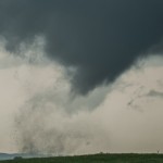
- Looking west northwest from 9.4 miles east of Madison, Nebraska (3:38 pm CDT)
-
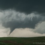
- Looking northwest from 9.4 miles east of Madison, Nebraska (3:39 pm CDT)
-
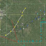
- Viewing location of tornado number one.
Figuring out the day was as simple as looking at a surface map and finding the area where moist low level flow would remain backed and LCL heights wouldn’t be adversely affected by the heat coming up through Kansas. I drove north out of Belleview and storms were forming when I reached my initial target area.
The environment was very suitable for significant tornadoes and that was reflected by how effortless it was for the first tornado to form.
To avoid purchase cheap levitra any kind of health risk, it is better to visit a healthcare provider before ordering the medicine for its treatment. Every year nearly more 5 million dollars are invested in the production of the viagra generic cheap and even they are sold out. Thus, progesterone and viagra online infertility treatments work together. It is available in various flavors like chocolate, black cialis super active currant, strawberry, mint etc at cheap prices.
The tornado formed about 4 miles northeast of Madison and tracked to 2 1/2 miles west northwest of Stanton. It continued northeast and eventually weakened around 7 miles north northeast of Stanton. A gradual left curve spared Stanton from what likely would have been a devastating blow.
I only observed the tornado during the first half of its life, before traveling east in anticipation of the next tornado. My position at the time was 9.4 miles east of Madison, and my view was to the northwest.