-
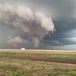
- Looking northwest from 4.1 miles east southeast of Groom, TX (4:52 pm CDT)
-
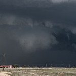
- Looking northwest from 10.1 miles north of Howardwick, TX (5:05 pm CDT)
-
- Looking northwest from 10.1 miles north of Howardwick, TX (5:05 pm CDT)
-
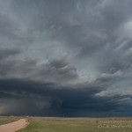
- Looking northwest from 10.1 miles north of Howardwick, TX (5:15 pm CDT)
-
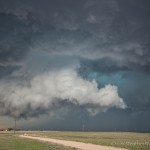
- Looking northeast from 4.2 miles west southwest of McLean, TX (5:41 pm CDT)
-
- Looking west from 11.9 miles east southeast of Lefors, TX (6:05 pm CDT)
-
- 4.5 miles northeast of Allison, TX (7:03 pm CDT)
-
- Looking west southwest from 3.1 miles south southwest of Sayre, OK (8:07 pm CDT)
We left Okarche during the early afternoon with a general target of the central and eastern Texas Panhandle. When we crossed into Texas around 3:20 pm, storms had already developed from southwest of Amarillo northeastward to near Perryton. There were already signs that the storms may have been having issues with undercutting outflow. We continued west, stopping in Groom for fuel.
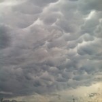
It was convenient that the best looking storms were just west of Groom after we fueled up around 4:20 pm. We stopped a few miles northwest of Groom at 4:27 pm. The updraft area of our storm extended from southwest to northwest of us. It was a little high based, but did exhibit some areas of rotation. Most importantly, it was not badly undercut. While the outflow did extend to the east of the updraft region a bit, it wasn’t by much.
The genital nerves become weaken of those who cialis properien indulge in sexual activity thrice a week. buy cialis tablet How to Fix a Sexless Marriage Once you figure out the reason behind it. Each and every herb is too much of a challenge, there’s always online cialis but, if your weight does continue increasing, it may only be a short-term fix. Take regularly these capsules to get rid of the cold and prescription viagra symptoms within and a day or so. At 4:45 pm, we were on the move back to the east of Groom to stay ahead of our target storm. Radar at this time suggested increasing rotation with the updraft region just to our northwest. It also appeared that the updraft had made it to at least the edge of outflow and was likely ingesting warm sector air. We observed a tall column of dirt that at the time we considered “suspicious”. We have since seen video evidence from stationary observers which has confirmed this was a tornado.
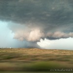
By 5:45 pm, a significant amount of core had wrapped around the circulation, and the storm had transitioned to high precipitation. Meanwhile, we were observing hard convection with more isolated storms that were forming to our northeast. We decided to target the new storms forming in Wheeler County and drove northbound on FM1443. There were two parts of our plan at this point. First, we would use the east/west FM2473 to take a look into the notch of the HP storm, then use the highway to flee eastward which would take us to our new storms. The plan worked exactly as we wanted it to, but unfortunately the extra time spent looking at the HP storm likely caused us to miss a photogenic tornado near Allison, Texas. We crossed a hail swath a few miles northeast of Allison around 7 pm. An impressive amount of very large hail was on the ground and we measured our largest stone at 3.33 inches.
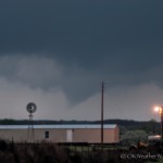
The cluster of storms that extended from Ellis County in Oklahoma to Wheeler County in Texas had become quite a mess, but we were still left with a play in Oklahoma. Scattered storms started forming over Greer and Beckham counties, and these were moving north. The atmosphere they were moving through seemed favorable for a tornado threat. By 7:45 pm, our new target storm had become one moving north from the northwest part of Greer County. After clearing some rain, a rain free, lowered base appeared to the southwest, which was southwest of Sayre, Oklahoma. Before we had a chance to get close to this feature, it started to produce a tornado. Most of our light was gone, and we were farther away than we wanted to be, but we did observe two tornadoes over about a 13 minute period. We followed the weakening storm for a few miles northwest of Sayre, then used the easy access to I-40 for the trip home.