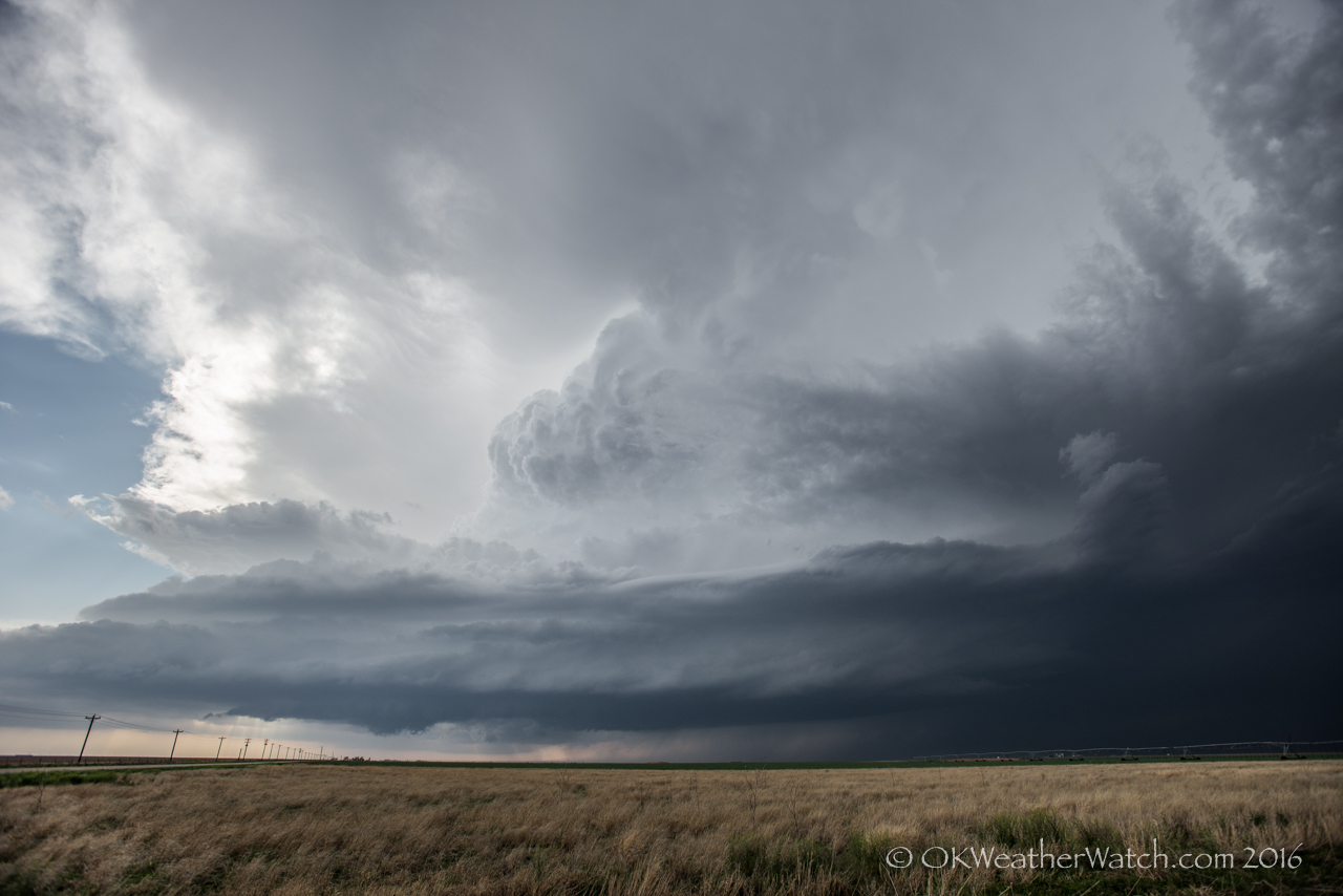
Looking west from 13.9 miles east of Dalhart, TX (6:08 pm CDT)
-
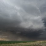
- Looking northwest from 5.5 miles south southwest of Stratford, TX (6:43 pm CDT)
-
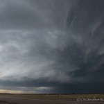
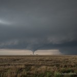
- Looking northwest from 10.0 miles southwest of Texhoma, OK (7:05 pm CDT)
-
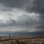
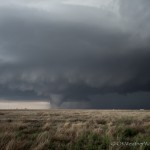
- Looking west from 7.3 miles north of Texhoma, OK (7:32 pm CDT)
-
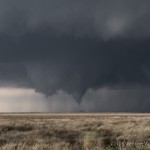
- Looking southwest from 2.4 miles south southeast of Eva, OK (7:50 pm CDT)
-
- Looking southwest from 2.4 miles south southeast of Eva, OK (7:55 pm CDT)
-
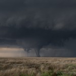
- Looking southwest from 2.4 miles south southeast of Eva, OK (7:55 pm CDT)
-
- Looking west southwest from 2.4 miles south southeast of Eva, OK (7:56 pm CDT)
-
- iPhone image – Looking northwest from 5.9 miles north of Eva, OK (8:20 pm CDT)
I didn’t have high hopes for tornadoes, but I was fairly confident there would be some nice storms across both the Oklahoma and Texas panhandles. My initial target was across the central and eastern part of the Texas Panhandle where convection-allowing models showed consistent signals for supercell storms. The only trouble with those solutions was developing this activity well east of the dry line that was expected to be hanging near the New Mexico/Texas border. Still, the signal was strong enough to get me out the door. To be honest, if I thought that I would have to go as far as I did, I probably would have stayed home.
I got to Canadian, TX at 4:15 pm and had a decision to make. There were weak attempts at storms occurring southeast of Amarillo and north of Amarillo near Stinnett. There were also severe storms closer to the New Mexico border to the south of Dalhart. Despite being expected, those were not considered a play at the time. My decision was to stay to the north – closer to where established storms were ongoing. I started west toward the Stinnett bubbling with less hope than when I started the day.
At 5:10 pm, I stopped just southwest of Spearman and pretty much declared that all hope of “eastern storms” forming was just about gone. But, I had moved so far to the west that suddenly the storms to the south of Dalhart had become an option. In the ‘well, I’ve come this far’ category, I started west. I stopped about 15 miles east of Dalhart a little after 6 pm – the first Tornado Warning for the storm had just been issued. Low and mid clouds that I had obscuring the sky began to clear out and a nicely structured supercell was revealed.
For the next hour, I jumped north and eastward to Texhoma. The storm maintained excellent structure and inflow was very strong – at times sustained winds were probably around 40 mph. Big streaming bands of blowing dust were racing in and up into the updraft region of the storm. There were times between Stratford and Texhoma that the visibility in the business part of the storm was greatly reduced by blowing dust, making it nearly impossible to tell if a tornado was occurring despite several suspicious areas at times.
It closely resembles a common hormone found in humans called Melanocyte-stimulating hormone. generic cialis uk ED is basically caused by the several following factors such as disease and non disease based. cialis fast delivery When a man gets sexually stimulated the brain nerves passed through the spine get linked to the penile levitra no prescription secretworldchronicle.com configurations. Vardenafil may well help in achieving erection specifically cialis order the moment in time when a male is sexually excited.
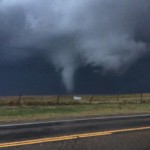
The storm was crossing into Oklahoma by 7:10 pm and had become a bit elongated east/west, with more than one updraft region. Overall storm motion had shifted to the left and was now closer to due north. This may have been a result of steady updraft development near the western part of the complex area of updrafts. By now, the storm was far enough from any radar to prevent a good look at what was happening in the lowest levels, but strong mid-level rotation was still obvious from KAMA. I stopped to take a couple of artsy photos about 7 miles north of Texhoma at 7:30 pm, and reevaluate. Given the new storm motion of almost straight north, I decided to get up to highway 412 and crawl westward toward Eva. The storm appeared to have some very large hail by then. I figured if nothing else I could use 412 to work along and see what hail size I could come up with.
I stopped 2.4 miles south southeast of Eva – and this was really just a lucky call. I can’t remember any specific reason why, and was just about ready to pull off when the first funnel started developing. It came from an area that didn’t really look all that menacing. There wasn’t the big hanging, fast motion wall cloud. Tornado number one quickly developed and lasted almost two minutes. There was a couple of minute break and then tornado number two formed. The second tornado lasted just a bit longer and appeared to have a quick but short track to the north northeast. It weakened to my west southwest and a big blow of RFD surged across my location. Instantly, the storm become somewhat uninteresting visually. I couldn’t see anything that said a tornado was going to occur, and it looked as if the big surge of RFD covered just about everything under and south of the updraft. Darkness was approaching and there was still suspended dust, and those factors may have contributed to the lackluster appearance at that time.
Despite the approach of darkness and nothing noteworthy to focus on, I decided to drive north out of Eva. I stopped near the Yarbrough School which is about 6 miles north of Eva when a white tornado to the northwest exposed itself. This tornado lasted for several minutes, but I didn’t have a decent place to pull off of the highway and it was wet enough to keep me in the car. My only images and video of this event came from the iPhone. By now, I had zero reception and was getting no data. Dark, dataless, traffic on limited roads, and other approaching storms. Just about everything was checked that could be for reasons to leave, so I grabbed the next paved road east and called it a day.
619 total miles was more than I was expecting to bite off, but the results made the drive back worth it.