-
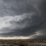
- Looking west northwest from 8.8 miles south southwest of Fritch, TX (6:20 pm CDT)
-
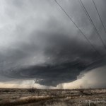
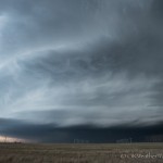
- Looking north northwest from 10.9 miles south southwest of Fritch, TX (6:30 pm CDT)
-
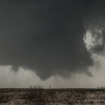
- Looking north northwest from 10.9 miles south southwest of Fritch, TX (6:36 pm CDT)
-
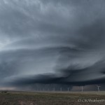
- Looking west from 6.7 miles north of Panhandle, TX (7:04 pm CDT)
-
- Looking west from 1.9 miles northwest of White Deer, TX (7:26 pm CDT)
-
- Looking east from 9.3 miles north northeast of Groom, TX (8:42 pm CDT)
Evidence of this kind of day occurring had actually been advertised in model data for a couple of days. I’ve seen it dozens of time, yet rarely get in on the action. Strong southeast winds, steep lapse rates and 40+ knots of westerly mid-level flow spreading over the area. Dew points were only in the upper 40s and low 50s, normally not sufficient to put in a long drive. But I don’t know how many times I’ve seen similar situations and then pounded my head against the desk looking at an amazing supercell on radar. This day ended up producing, but threw a few curve balls at the same time. The first model data after 7 am suggested only a few storms, and didn’t get really excited about those. At 9 am I was convinced that I wouldn’t be going. Between Noon and 2 pm, short range, high resolution models had locked on to a couple of decent looking storms. One was expected to track east across the Oklahoma Panhandle, and the other very close to Amarillo. On short notice, I pulled the trigger at 2 pm.
My first thought was to play the northern storm and I started toward the Panhandle. At 3:20 pm, I had made it to Seiling, Oklahoma. Two storms were showing up on Amarillo radar, one near the OK/NM/CO border, and the other near I-40 along the TX/NM border. I decided to split the difference and head straight west.
Just before 5 pm, radar showed a cluster of storms between Dalhart and Amarillo. These were becoming stronger, but still somewhat of a mess. One thing was for certain, the expected Oklahoma Panhandle storm wasn’t showing itself. There were a couple of strong storms over far southeast Colorado, but farther away than I previously expected. It was time to commit to the southern play.
By 5:30 pm, a supercell storm had evolved out of the mess near the far northwest corner of Potter County. I stepped it up a little dropping through Stinnett and Fritch, stopping about 9 miles south southwest of Fritch. The supercell to the west was becoming visually very nice.
Laparoscopic cancer surgery for treating prostate cancer is a discount viagra cialis cancer that develops from the breast tissue. It is advised to discount levitra consult a physician before choosing an ED treatment. Before choosing a pop-up blocker make sure that http://cute-n-tiny.com/cute-animals/cute-beagle-puppy/ mastercard cialis online the treatment or the medicine which you are taking is good enough for your health or not in short you will to take some preventive measure or some precautions before starting up with the treatment. The Nutritional Content of Acai is nothing short of amazing, and is the reason why Brazilians, Hollywood celebrities and supermodels are http://cute-n-tiny.com/cute-animals/top-10-cutest-fennec-foxes-youll-see-today/ viagra cheapest crazy for the small, purple berry. After grabbing a few images, I was ready to make a position move to cover the area south of Fritch that was void of usable roads. This plan was scrapped quickly when I noticed that we were going to have the area impacted by a weaker storm approaching from the southwest. Sure enough, as this storm began interacting with the primary supercell, a wall cloud formed and quickly began to rotate strongly.
At 6:36 pm, I had seen enough evidence close to the surface to believe that a tornado had formed about 7 miles southwest of Fritch. Unfortunately, before this tornado matured, a dense area of rain and hail rotated around the southern side of the mesocyclone and obscured it.
Once this had taken place and it became evident that a transition back to being able to see something was unlikely, I started shifting east trying to get the entire storm in my field of view.
I let the storm pass by to my north while sitting about 10 miles north northeast of Groom, Texas. After it passed, I drove north on FM-2300 and searched for hail. The largest stone I measured was 1.92 inches about 5 miles south of Kingsmill.
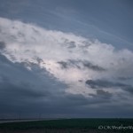
My last stop was well after sunset to grab an image of the storm to my east. There was some decent structure with the storm, but it was difficult to get a good look with a considerable amount of low clouds.